Isolated Showers Likely Through Tuesday, Some Could Be Heavy

As a front pushes it way though Western North Carolina, isolated showers will be possible throughout the day on Tuesday. This will bring some much needed rainfall to some locations around the area. Below is the most recent run of the NAM 3km, and as you can see the totals vary greatly from valley to valley. Therefore, some locations could see over 1” of rainfall (especially as you get closer to the NC/TN border), while other locations barely manage a tenth of an inch. This is because this system will be moving in from E TN, and downsloping will dry out the system as it progresses East.

NAM 3km Precipitation Courtesy of Weathermodels.com

Contact my local trusted roofing source Matt at RedWolf Contracting Services to take care of all of your roof replacements. From shingles, to metal roofing, and even commercial rubber membrane, Matt has the resources and solutions to take care of yo…

Contact my local trusted roofing source Matt at RedWolf Contracting Services to take care of all of your roof replacements. From shingles, to metal roofing, and even commercial rubber membrane, Matt has the resources and solutions to take care of your job in a professional and cost effective manner. Call (828) 772-9778 or visit nc-roofers.com to set up your free roof inspection.

Will This Break The Drought?

For some locations along the NC/TN border this could certainly break the drought. Higher locations could see as much as 3” of rainfall from this system as the moisture is strained out along the spine of the Appalachians. But for others down in certain valleys away from the NC/TN border, only minimal precipitation will fall. On the map above you can see that it only shows around .2” of rainfall for the Asheville Airport, but has precipitation maximums of 4”+ along the NC/TN border. On this model run the Franklin station is projected to pick up over an inch of rainfall. Does that come to fruition? I am not sure. These type events will hammer some valley locations, but leave others dry.. so a general rule of thumb is that if you are within 20 miles of the NC/TN border, you can expect twice the rainfall compared to locations 30-40 miles away.

Call the team that keeps my truck clean at A&R Specialist! David, Matt & Harley run A&R Specialist at 621 Brevard Rd. and they are the guys to trust with your vehicle cleaning & detailing. Whether you need a deep wax every once in a …

Call the team that keeps my truck clean at A&R Specialist! David, Matt & Harley run A&R Specialist at 621 Brevard Rd. and they are the guys to trust with your vehicle cleaning & detailing. Whether you need a deep wax every once in a while or a quality clean and detail, you can feel safe putting your car in the hands of A&R Specialist! Call (828) 708-3718 to set up your appointment today. https://www.facebook.com/ARpressurewashing4/

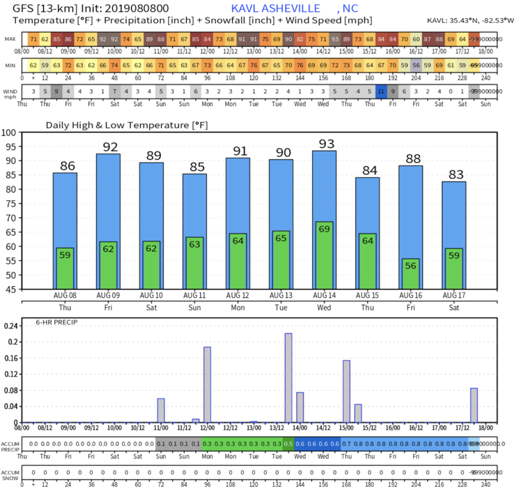
Cooler Air Is Coming

The European model continues to show Fall temperatures throughout the next 10 days, so it should be very nice around WNC! The mornings will eventually begin to cool off after this first front passes, and next weekend we could even see temperatures in the low to mid 40’s. This will continue to aid leaf change progression around WNC, and I am still expecting a somewhat spectacular fall color showing this year, even though the leaves are a couple of days late! Click Here to view my 2019 Fall Foliage Forecast!

Courtesy of Weathermodels.com


Watch The Season Change Live In WNC On The HD Live Cameras


Record High Temps Likely Today And Tomorrow, Then Two Cold Front Moves In

The record for high temperature on this date in Asheville (October 2nd) is 87 degrees set back 120 years ago in 1897. Today, just like yesterday, that record could fall. Tomorrow the record high temperature is 88 degrees set back in 1954, and that record could likely fall as well with many models indicating that 90 degrees could be possible. Below you can see the most recent European model run and it shows the next several days of temperatures. After we get through the next two days, it appears that Fall will finally arrive!

Courtesy of Weathermodels.com

Call the team that keeps my truck clean at A&R Specialist! David, Matt & Harley run A&R Specialist at 621 Brevard Rd. and they are the guys to trust with your vehicle cleaning & detailing. Whether you need a deep wax every once in a …

Call the team that keeps my truck clean at A&R Specialist! David, Matt & Harley run A&R Specialist at 621 Brevard Rd. and they are the guys to trust with your vehicle cleaning & detailing. Whether you need a deep wax every once in a while or a quality clean and detail, you can feel safe putting your car in the hands of A&R Specialist! Call (828) 708-3718 to set up your appointment today. https://www.facebook.com/ARpressurewashing4/

Not One But Two Cold Fronts Are On The Way

These nasty upper 80’s and 90’s are on their way out for WNC, and two cold fronts will push through the area with the second bringing another chance for rainfall. The first frontal passage will occur Friday afternoon, and a few pop-up showers could occur, but I am not expecting anything significant. The second front though that will move though Tuesday at some point in time does have rain making potential. The European model only shows around .3” of rainfall being possible, while the GFS indicates a more potent rainmaker, and shows well over .5” of precipitation possible. This does appear to be an upper level low, and that strong energy will make this storm somewhat difficult to predict, so expect this forecast to change some. We could be talking about severe storms with this frontal passage on Tuesday as well, so stay tuned for more information regarding that.

Courtesy of Weathermodels.com

Courtesy of Weathermodels.com

Contact my local trusted roofing source Matt at RedWolf Contracting Services to take care of all of your roof replacements. From shingles, to metal roofing, and even commercial rubber membrane, Matt has the resources and solutions to take care of yo…

Contact my local trusted roofing source Matt at RedWolf Contracting Services to take care of all of your roof replacements. From shingles, to metal roofing, and even commercial rubber membrane, Matt has the resources and solutions to take care of your job in a professional and cost effective manner. Call (828) 772-9778 or visit nc-roofers.com to set up your free roof inspection.

Fall Color Update

Some of the highest elevations are beginning to reach peak, and they are a couple of days behind. I expect that trend to somewhat continue as the color traverses down in elevation, but if this cold pans out that will accelerate the process. The rainfall that most received over the past few days will be very beneficial to lower elevation leaf retention, and leaves should hold on to the trees a bit longer, allowing color to become somewhat vibrant. Be sure to share your pictures with AshevilleWX and also share them with RomanticAsheville.com on Instagram using the hashtag #RAlivefallcolor.

Extended Cool Down On Tap For WNC Next Weekend

It has been hot around WNC! Currently September of 2019 ranks 3rd for the hottest September ever recorded in WNC! With the average temperature currently for the whole month at 73.3 degrees, it ranks just behind 1925 (73.6 degrees), and 2018 at (74.1 degrees). With temperatures expected to reach close to 85 again today and tomorrow, we could easily see 2019 move into second place behind 2018.

A Cool Down Is Coming!

Finally the long range models are beginning to lock onto an extended period of average to below average temperatures. We should at least experience 3-4 days of 70 degree highs, and lows in the mid to upper 40’s next weekend. Below you can see the most recent GFS model run, and it indicates that mid 40’s will be possible early next Saturday morning. This will finally feel like fall, and it will be fitting since fall is already here lol.

Courtesy of Weathermodels.com

How Much Rainfall Will WNC Receive This Week?

This is a great question, and will vary from valley to valley around WNC. Yesterday I saw reports of some locations seeing over 2” of rainfall from the strong storm that developed in South Asheville. At my location in Alexander, NC I received .05” of rainfall. So, some locations got hammered with rain, while others barely receive any precipitation. Looking ahead, that theme appears to continue. Storms will be possible Sunday, Monday, & Tuesday around WNC, and then we will see another front late next week. Below you can see the most recent NAM 3km model run.

courtesy of Weathermodels.com

Contact my local trusted roofing source Matt at RedWolf Contracting Services to take care of all of your roof replacements. From shingles, to metal roofing, and even commercial rubber membrane, Matt has the resources and solutions to take care of yo…

Contact my local trusted roofing source Matt at RedWolf Contracting Services to take care of all of your roof replacements. From shingles, to metal roofing, and even commercial rubber membrane, Matt has the resources and solutions to take care of your job in a professional and cost effective manner. Call (828) 772-9778 or visit nc-roofers.com to set up your free roof inspection.

Wetter Pattern In Store

Most long range models now show a somewhat wet pattern beginning late next week around WNC, and that is great news. Currently all locations around WNC are in a drought, and there are several burn bans in place including one for Buncombe County. Below you can see the most recent European Model run and it suggests that a good slug of moisture will likely move in late next weekend or early next week. We haven’t seen precipitation like this showing up on long range models for some time, so in my opinion this is a very good sign regarding breaking out of the drought.

Courtesy of Weathermodels.com

Drought Monitor

Below is the Southeast Drought Monitor produced every Thursday by the USDA. This week, many locations in WNC were added to this map. The progressing pattern though appears to bring in more moisture compared to what we have seen over the past month, so there is a decent chance that we could break out of this drought in the next two weeks. Stick with me here at AshevilleWX and I will keep you updated!

Call the team that keeps my truck clean at A&R Specialist! David, Matt & Harley run A&R Specialist at 621 Brevard Rd. and they are the guys to trust with your vehicle cleaning & detailing. Whether you need a deep wax every once in a …

Call the team that keeps my truck clean at A&R Specialist! David, Matt & Harley run A&R Specialist at 621 Brevard Rd. and they are the guys to trust with your vehicle cleaning & detailing. Whether you need a deep wax every once in a while or a quality clean and detail, you can feel safe putting your car in the hands of A&R Specialist! Call (828) 708-3718 to set up your appointment today. https://www.facebook.com/ARpressurewashing4/

Watch The AshevilleWX Live HD Camera To See The Leaves Change!

Drought Builds In WNC, Scattered Storms Expected This Weekend

The most recent drought monitor was released yesterday by the USDA, and all of WNC is now considered to be in a drought. The severity of drought varies greatly from valley to valley, but the overall sentiment is that the ground is extremely dry, and several inches of rain will be needed to break that. Below you can see the most recent drought monitor produced by the USDA.

Call the team that keeps my truck clean at A&R Specialist! David, Matt & Harley run A&R Specialist at 621 Brevard Rd. and they are the guys to trust with your vehicle cleaning & detailing. Whether you need a deep wax every once in a …

Call the team that keeps my truck clean at A&R Specialist! David, Matt & Harley run A&R Specialist at 621 Brevard Rd. and they are the guys to trust with your vehicle cleaning & detailing. Whether you need a deep wax every once in a while or a quality clean and detail, you can feel safe putting your car in the hands of A&R Specialist! Call (828) 708-3718 to set up your appointment today. https://www.facebook.com/ARpressurewashing4/

Locations to the Northeast of Asheville have been significantly drier compared to locations in the French Broad River Valley, and that is hard to believe considering how dry it has been around Asheville. That also holds true when you travel to the Southwest of Asheville. Severe drought has even been designated in parts of Macon County. A pattern change is needed in the worst way, and some long range models indicate that being possible.. but its at least a week away.

Slight Relief On The Way This Weekend For WNC

Short range models indicate that scattered thunderstorms will be possible each afternoon over the weekend for select locations. There’s no guarantee that your house will see rainfall, but the chances will certainly increase as we push through the weekend and into early next week. Below you can see the most recent NAM 3km and what it shows for this weekend.

courtesy of Weathermodels.com

Contact my local trusted roofing source Matt at RedWolf Contracting Services to take care of all of your roof replacements. From shingles, to metal roofing, and even commercial rubber membrane, Matt has the resources and solutions to take care of yo…

Contact my local trusted roofing source Matt at RedWolf Contracting Services to take care of all of your roof replacements. From shingles, to metal roofing, and even commercial rubber membrane, Matt has the resources and solutions to take care of your job in a professional and cost effective manner. Call (828) 772-9778 or visit nc-roofers.com to set up your free roof inspection.

Leaf Stress

Some leaves around the area appear to be experiencing some stress, and in turn they are beginning to yellow earlier. Check out this tweet from a local weather expert Evan Fisher:


Many area trees are ahead of schedule as far as yellowing, and that appears to be due to the drought that has built over the past 2 months. The chlorophyll is already dying out in some leaves, and that accelerates their changing process. I am not exactly sure how this will affect the overall vibrancy of leaves this year in WNC, but one would imagine that it would have a negative influence. Ideally all leaves will die at the same time so that the tree will all turn its designated color at once. If leaves begin to die before others, then the color will be spotty in nature. Pictures are beginning to come in though of higher elevation leaf change, so time will tell regarding vibrancy.


Watch Leaves Change In WNC On The Live HD Webcams


Cold Front, Fall Like Temperatures Headed To WNC By Mid Week

A refreshing cold front is finally on the way for Western North Carolina, and temperatures Thursday and Friday morning will dip into the low 50’s and even upper 40’s in some locations! This will be such a relief for most as we have seen 6 days where we reached 90 degrees in September at the Asheville Airport.. Needless to say, it has been hot! Below you can see the most recent GFS model, and it shows temperatures in the 70’s for the high on Wednesday!

Wednesday Afternoon Temperatures Per GFS Provided By Weathermodels.com

Call the team that keeps my truck clean at A&R Specialist! David, Matt & Harley run A&R Specialist at 621 Brevard Rd. and they are the guys to trust with your vehicle cleaning & detailing. Whether you need a deep wax every once in a …

Call the team that keeps my truck clean at A&R Specialist! David, Matt & Harley run A&R Specialist at 621 Brevard Rd. and they are the guys to trust with your vehicle cleaning & detailing. Whether you need a deep wax every once in a while or a quality clean and detail, you can feel safe putting your car in the hands of A&R Specialist! Call (828) 708-3718 to set up your appointment today. https://www.facebook.com/ARpressurewashing4/

Some Locations Could See 40’s Friday AM

Some models are suggesting that upper 40’s will even be possible for a few locations on Friday morning. Below you can see the most recent GFS model, and as you can see on Friday AM many locations bottom out in the mid to upper 40’s. Boone could even get into the Mid 40’s with the GFS showing that 45 degrees will be possible!

Friday Am Temps Per 6z GFS Courtesy of Weathermodels.com

Contact my local trusted roofing source Matt at RedWolf Contracting Services to take care of all of your roof replacements. From shingles, to metal roofing, and even commercial rubber membrane, Matt has the resources and solutions to take care of yo…

Contact my local trusted roofing source Matt at RedWolf Contracting Services to take care of all of your roof replacements. From shingles, to metal roofing, and even commercial rubber membrane, Matt has the resources and solutions to take care of your job in a professional and cost effective manner. Call (828) 772-9778 or visit nc-roofers.com to set up your free roof inspection.

How Will This Cold Front Impact Fall Color?

It should kick off the color change season across the High Country Of WNC. These low temperatures are what are needed to begin the process (which has already began in some locations), and it appears we will have 2-3 mornings of below average temperatures. So if you read my 2019 Fall Color Outlook For WNC you know that we were expecting this cold front, but how long it lasts is still up in the air. I expect to begin to see more of these cold fronts move through as we progress towards October, and as each one moves through, the fall color will enhance! Check below to see the fall color change on the AshevilleWX Live Webcams!

Watch The Fall Color Change Live On The AshevilleWX Live HD Webcams

WNC HD Webcams

Dorian Poses No Threat To Mountains Of WNC

With a landfall possible along the NC Coast, many have been asking me about the affects here in Western North Carolina. Models do not indicate that any rainfall will make it this far north and west for Dorian. Some gusty winds could be possible, as the storm exist off the coast, but these will not be strong than 25 mph. In fact, I am not really even expecting any rainfall over the next 5 days. Some pop-up afternoon storms will be possible, but these will be scattered, and will not be associated with Hurricane Dorian. Below is the most recent European model projected precipitation for the next 5 days.

Courtesy of Weathermodels.com

Courtesy of Weathermodels.com

Call the team that keeps my truck clean at A&R Specialist! David, Matt & Harley run A&R Specialist at 621 Brevard Rd. and they are the guys to trust with your vehicle cleaning & detailing. Whether you need a deep wax every once in a …

Call the team that keeps my truck clean at A&R Specialist! David, Matt & Harley run A&R Specialist at 621 Brevard Rd. and they are the guys to trust with your vehicle cleaning & detailing. Whether you need a deep wax every once in a while or a quality clean and detail, you can feel safe putting your car in the hands of A&R Specialist! Call (828) 708-3718 to set up your appointment today. https://www.facebook.com/ARpressurewashing4/

Heat, Very Little Rain Expected Over Next 7 Days

Through next Tuesday, most models show very little rainfall for the area. In-fact, the Euro shows only .1” of rain likely for most through next Tuesday. It will be good hay cutting weather, but your garden and flowers may need some love! This bodes well for Fall foliage, if you remember last year we were extremely wet during this period and that played a huge part in the slow leaf change. Look for my fall color outlook in the next 2 weeks!

Contact my local trusted roofing source Matt at RedWolf Contracting Services to take care of all of your roof replacements. From shingles, to metal roofing, and even commercial rubber membrane, Matt has the resources and solutions to take care of yo…

Contact my local trusted roofing source Matt at RedWolf Contracting Services to take care of all of your roof replacements. From shingles, to metal roofing, and even commercial rubber membrane, Matt has the resources and solutions to take care of your job in a professional and cost effective manner. Call (828) 772-9778 or visit nc-roofers.com to set up your free roof inspection.

Great Uncertain Remains With Dorian Track

Where Tropical Storm Dorian heads over the next 5-7 days is somewhat of a current mystery, and all locations along the Southern East Coast should be watching. Many models indicate that a Florida landfall could be possible, but with each passing run, the track shifts in one direction or another. Below you can see the current spread of model tracks, along with the National Hurricane Centers Cone.

Contact my local trusted roofing source Matt at RedWolf Contracting Services to take care of all of your roof replacements. From shingles, to metal roofing, and even commercial rubber membrane, Matt has the resources and solutions to take care of yo…

Contact my local trusted roofing source Matt at RedWolf Contracting Services to take care of all of your roof replacements. From shingles, to metal roofing, and even commercial rubber membrane, Matt has the resources and solutions to take care of your job in a professional and cost effective manner. Call (828) 772-9778 or visit nc-roofers.com to set up your free roof inspection.

Here is a zoomed in version near the Atlantic Coast of FL.

This is considered a “Hurricane Spaghetti Plot” and shows all current model tracks. These are just possibilities from the most recent run of a given model. This gives meteorologist an overview of all possible model tracks.

Intensity Forecast

There is also a large spread among models as to how strong exactly Dorian gets. Currently the storm is entraining dry air, and that is hindering the atmosphere around the storm from properly stacking itself. Models forecast this dry air to subside as the storm approaches the Bahamas later this week, but how much strengthening occurs as it approaches the US is still very unclear. For now, all locations along the Southern East Coast (NC,SC,GA,FL) need to be watching. We could see dry air rip this storm apart, but given what most models are showing, that appears less likely. The National Hurricane Center believes that Dorian can reach Category 2 status by Fri night- or Saturday, baring down in the Atlantic Coast of Florida. With these systems though, we have seen projected tracks this far out be wrong, and that is why I am advising all on the Southern Atlantic Coast to pay attention. Even locations like Miami are not out of the potential path, and it will take several more model runs to get a better picture. Stay tuned though, I will keep you updated on the progression.

Call the team that keeps my truck clean at A&R Specialist! David, Matt & Harley run A&R Specialist at 621 Brevard Rd. and they are the guys to trust with your vehicle cleaning & detailing. Whether you need a deep wax every once in a …

Call the team that keeps my truck clean at A&R Specialist! David, Matt & Harley run A&R Specialist at 621 Brevard Rd. and they are the guys to trust with your vehicle cleaning & detailing. Whether you need a deep wax every once in a while or a quality clean and detail, you can feel safe putting your car in the hands of A&R Specialist! Call (828) 708-3718 to set up your appointment today. https://www.facebook.com/ARpressurewashing4/

Will Dorian Affect WNC?

The short answer is that I do not know, lol. If it does, it would be on Monday and into Tuesday of next week. There is no trough coming to quickly push Dorian out to sea after its potential landfall, so it will likely bury itself into the interior of the US. If that happens, WNC could experience wind gusts and heavy rainfall from its progression. As of right now though, I believe that this weekend will be beautiful around WNC, and any affects from Dorian will be pushed to the early part of the week. Check back soon, I will make sure you are updated on how Dorian will affect WNC!

Heat Returns To WNC To End Week

After this front finally pushes through, another round of heat will build in the area. Temperatures on Thursday and Friday will be in the mid to upper 80’s, and it will again feel like summer. This begins the cycle though in my opinion of progressing towards Fall. That means cooler mornings (below 60 degrees) and afternoon temperatures in the low to mid 80’s. If you remember last year, we reached 90 degrees in mid October in Asheville, so there are still many more warm days to come. Below you can see the most recent GFS temperatures spread for Thursday afternoon.

Courtesy of Weathermodels.com

Call the team that keeps my truck clean at A&R Specialist! Matt & Harley run A&R Specialist at 621 Brevard Rd. and they are the guys to trust with your vehicle cleaning & detailing. Whether you need a deep wax every once in a while o…

Call the team that keeps my truck clean at A&R Specialist! Matt & Harley run A&R Specialist at 621 Brevard Rd. and they are the guys to trust with your vehicle cleaning & detailing. Whether you need a deep wax every once in a while or a quality clean and detail, you can feel safe putting your car in the hands of A&R Specialist! Call (828) 708-3718 to set up your appointment today. https://www.facebook.com/ARpressurewashing4/

Lower Humidity Expected

Humidity values over the next several days will drop dramatically. On Thursday and Friday, Relative Humidity around WNC will drop into the 40% range each afternoon. That will make it feel very nice around Western North Carolina! Most models indicate that clouds will clear on Thursday and Friday, and these days will be near picture perfect. Below you can see the most recent GFS model Relative Humidity projections. On both Thursday and Friday afternoon’s values will dip below 40%. That means that the moisture content in the air will be lower, and thus the air will feel more favorable to the touch for most. Thursday and Friday will be great days to work outside! If you are looking to cut hay, this would be a good weekend to partake. If you could cut on Thursday and gather on Sunday, that would be ideal for most! Pop-up showers will increase into the weekend, but these will still be scattered in my opinion.

Contact my local trusted roofing source Matt at RedWolf Contracting Services to take care of all of your roof replacements. From shingles, to metal roofing, and even commercial rubber membrane, Matt has the resources and solutions to take care of yo…

Contact my local trusted roofing source Matt at RedWolf Contracting Services to take care of all of your roof replacements. From shingles, to metal roofing, and even commercial rubber membrane, Matt has the resources and solutions to take care of your job in a professional and cost effective manner. Call (828) 772-9778 or visit nc-roofers.com to set up your free roof inspection.

Courtesy of Weathermodels.com

Cold Front, Excessive Moisture Moves Into WNC Late This Weekend

A cold front appears to be in store for WNC late Saturday and into Sunday as we finally get a bit of relief from the heat! Rain will also move through with this, and many areas around WNC could use it! Some models show over 2” of rainfall for some locations through Monday AM. Below you can see the European model’s precipitation totals through the weekend.

Model provided by Weathermodels.com

Model provided by Weathermodels.com

Contact my local trusted roofing source Matt at RedWolf Contracting Services to take care of all of your roof replacements. From shingles, to metal roofing, and even commercial rubber membrane, Matt has the resources and solutions to take care of yo…

Contact my local trusted roofing source Matt at RedWolf Contracting Services to take care of all of your roof replacements. From shingles, to metal roofing, and even commercial rubber membrane, Matt has the resources and solutions to take care of your job in a professional and cost effective manner. Call (828) 772-9778 or visit nc-roofers.com to set up your free roof inspection.

Below average temperatures are in store for the area over the next 6-10 days as you can see on the map below provided by the Climate Prediction Center. This will pair with a period of slightly above average moisture. For many who have not seen significant rainfall in the last couple of weeks, this is a great sign! I expect widespread rainfall late Saturday night and into most of the day Sunday.

Courtesy of CPC

Call the team that keeps my truck clean at A&R Specialist! Matt & Harley run A&R Specialist at 621 Brevard Rd. and they are the guys to trust with your vehicle cleaning & detailing. Whether you need a deep wax every once in a while o…

Call the team that keeps my truck clean at A&R Specialist! Matt & Harley run A&R Specialist at 621 Brevard Rd. and they are the guys to trust with your vehicle cleaning & detailing. Whether you need a deep wax every once in a while or a quality clean and detail, you can feel safe putting your car in the hands of A&R Specialist! Call (828) 708-3718 to set up your appointment today. https://www.facebook.com/ARpressurewashing4/

Fall Feel Is Coming

It will feel a lot more Fall-like around WNC after this weekend for WNC. As you can see above, the outlook for the next 6-10 days for WNC temperature-wise will be very mild. I expect highs in the mid to upper 70’s, or very low 80’s, and mornings in the upper 50’s. Below is the afternoon highs for next Tuesday per the European model. It currently only shows the potential for mid 70’s each afternoon next week. That would be very refreshing after flirting with 90 for the past several days. I will keep you updated on this front so stay tuned to AshevilleWX and be sure to check the 5-day forecast!

AugHighsAfternoon.png

Another Heatwave Expected For Southeast Next Week

From near record cool temperatures last week, to the potential for mid 90’s next week around WNC. The past few weeks have been a rollercoaster weather-wise. That theme will continue through the near future with high pressure building over the southeast. Some locations could push over 100 degrees again, and some models are even showing temperatures in the mid to upper 90’s in WNC. I am not sure that WNC will actually get that hot, but the possibility is certainly there. In fact, temperatures on Tuesday of next week could be the hottest of the year so far. Below is the most recent European model run and you can see the expected temperatures across the southeast for Tuesday afternoon. Widespread 95+ temps are likely with some triple digit temperatures possible to our east.

Map courtesy of Weathermodels.com

Call the team that keeps my truck clean at A&R Specialist! Matt & Harley run A&R Specialist at 621 Brevard Rd. and they are the guys to trust with your vehicle cleaning & detailing. Whether you need a deep wax every once in a while o…

Call the team that keeps my truck clean at A&R Specialist! Matt & Harley run A&R Specialist at 621 Brevard Rd. and they are the guys to trust with your vehicle cleaning & detailing. Whether you need a deep wax every once in a while or a quality clean and detail, you can feel safe putting your car in the hands of A&R Specialist! Call (828) 708-3718 to set up your appointment today. https://www.facebook.com/ARpressurewashing4/

Chances Decrease For Rain Over Next 5 Days

As high pressure builds in, the chance for rainfall will greatly decrease around the area. Some locations saw over an inch of rainfall over the past week, but other locations in WNC have barely seen a drop. At my house in Alexander, I recorded .07” of rain over the past 7 days with storms popping up each afternoon around me. This is just the nature of pop-up summertime storms that are not associated with a frontal boundary passage. So, drought conditions will be possible for locations who have not experienced significant rainfall. Below is the GFS data output for the next 10 days.

GFS Output Provided By Weathermodels.com

GFS Output Provided By Weathermodels.com

Contact my local trusted roofing source Matt at RedWolf Contracting Services to take care of all of your roof replacements. From shingles, to metal roofing, and even commercial rubber membrane, Matt has the resources and solutions to take care of yo…

Contact my local trusted roofing source Matt at RedWolf Contracting Services to take care of all of your roof replacements. From shingles, to metal roofing, and even commercial rubber membrane, Matt has the resources and solutions to take care of your job in a professional and cost effective manner. Call (828) 772-9778 or visit nc-roofers.com to set up your free roof inspection.

Hydration & Sunscreen Needed

Please make sure and stay hydrated over the next 7 days. During these dry heatwaves your body needs excessive amounts of water to continue normal processes. If you are working outside, make sure to wear a hat and cover exposed areas with high SPF sunscreen. A break from the heat looks likely late next week, but we have to make it through the next several days first! Please be safe, and check on elderly neighbors to ensure they are properly cooling.