Rain Today, Then Northwest Flow To Bring Accumulating Snow To Many Tomorrow

Another Round Of Northwest Flow Snow For WNC

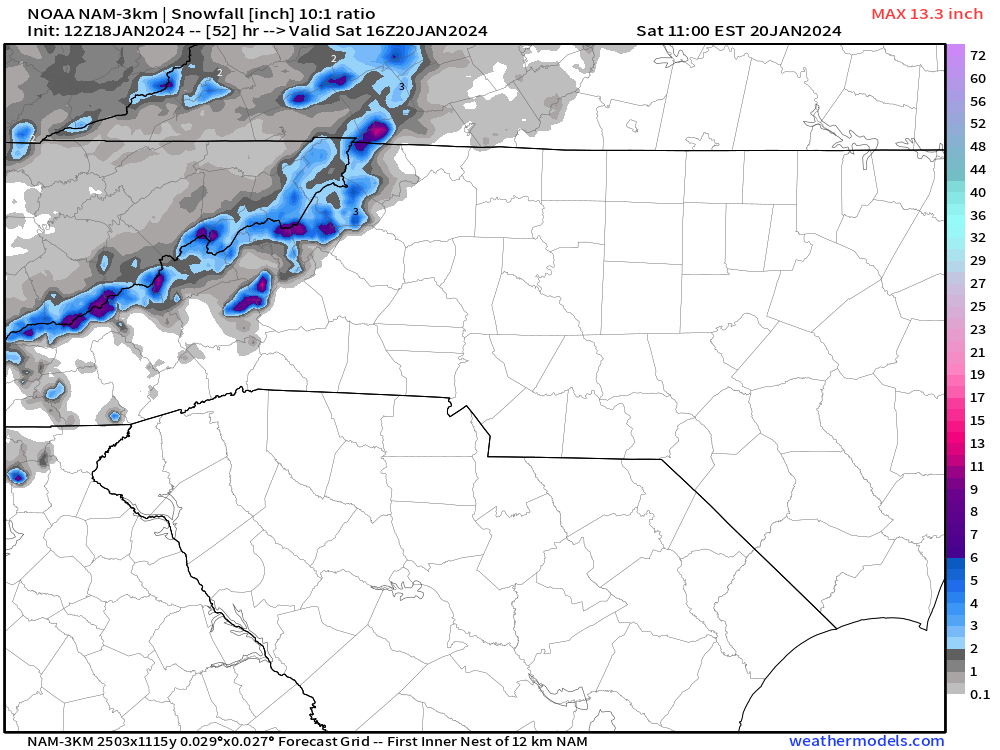
Yes, another round of Northwest flow is on the way, and some high elevations locations are going to get hammered with 6”-12”+ inches of snowfall Sunday and into Monday. This will replenish the snow that has melted over the past few days with the temperature increase/rain. This flow looks to be very stout, similar to the one we saw last week, but it seems to be a bit more intense. The timing is also a bit more conducive for accumulation to occur as the main moisture will move in at sunset instead of sunrise. I suspect that locations around Asheville and just north could rake in another 1-3”, similar to the last event. Rates will not be as strong though as temps will remain in the low 30’s as snow falls. Therefore I can see this being a wet snow that sticks to everything. Below is my projected accumulation map for this event as well as a projected radar from the 12z NAM 3km.

Heavy Rain/A Few Rumbles of Thunder Today For WNC

Areas South of Asheville will see consistent rainfall throughout most of the day today as the front moves through. Most models show around an inch of rainfall possible for Hendersonville and as you get closer to Asheville those totals diminish to .6”-.7” of precip. Below you can see the most recent Nam 3km precipitation totals through this evening. The ground is already very wet so some flash flooding could occur.

NAM 3km Precip Totals Through Sat Evening Courtesy of Weathermodels.com

Snowfall Timing

When will snow begin around WNC? Most models suggest that snow will begin in the high elevations above 3500’ around 8-10am, and then by 1-2pm snow showers will begin to drift into valley locations like Asheville and Waynesville. I expect this snow to pick up in the valley floor areas as the sun sets, so it would be wise to be where you need to be on Sunday evening by 4-5pm. Snow will really become heavy for most locations north of I-40 as the sun sets around 6pm. Check out the most recent NAM3km simulated radar and snowfall projection.

12z 3kmNAM Simulated Radar Courtesy of Weathermodels.com

12z Nam3km Snowfall Accumulation Map Courtesy of Weathermodels.com

Live Update Today At 4:30

Tune in on Facebook and Youtube for a live update on the upcoming weather pattern at 4:30. I see 3 chances for snowfall over the next 10 days around WNC so buckle up, this warm weather is gone.

Wintry Weather, High End Northwest Flow Event On Tap For WNC

Wintry Weather, High End Northwest Flow Event On Tap For WNC

Another wave of precipitation will move in later this evening around WNC, and some locations could have freezing rain, sleet, or even snow fall as the precip begins. Locations closer to the Boone area have a chance to stay snow throughout a good portion of this event and another 3”-6” of snowfall looks possible for locations above 3500’ along the NC/TN state line. Models limit an frozen precipitation around the Asheville area Thursday night, but there is still a chance for freezing rain. This is a complicated system, but on the backside Friday we are very likely to see a high end Northwest Flow event. This means that snow showers will likely break containment from the higher elevations and push into the Downtown Asheville area. You can see below on the most recent Nam3km model. I look for those little fingers of moisture to push from Madison Co. all the way down through Buncombe Co. That indicates to me that a ripe channel of moisture and force will push out of the high elevations and bring precipitation to the valley floor.

Simulated Radar Courtesy of Weathermodels.com

How Much Snow Is Possible?

For locations above 4000’ along the NC/TN line I believe another 6”-12” of accumulation could be possible through early Saturday morning. As you progress down in elevation, I expect 3”-6” of accumulation between 4000’ and 3500’ along the NC/TN border, and then a dusting to 1” will even be possible around the Asheville area. High winds will carry a moist flow out of the high elevations, and with very cold temps I am thinking this is the best Northwest flow setup we have seen in a couple of years. Asheville has been known to pick up a quick inch or two from these heavy flows, so it is certainly possible. For locations South of Asheville, I think Fairview and Black Mountain should do well with this flow. Locations like Hendersonville and Brevard typically only see flurries from these type flows, but could see an intermittent snow shower if the flow is strong enough. Check out the most recent accumulation map from the Nam3km below.

Nam3km Snowfall Accumulation Map Courtesy of Weathermodels.com

Storm Effects

This storm will affect you in many ways depending on your location. Temps will plummet into the low teens again for many early Saturday morning and that will stress infrastructure. We will also have snow showers still falling and many covered roadways north of I-40. It would be best to plan to stay home on Saturday morning if possible. Below you can see the Nam3km projected temps for Saturday AM.

NAM3km Temps 6am Saturday AM Courtesy of Weathermodels.com

Live Update Tonight At 6pm

Check in tonight on Facebook or Youtube at 6pm, I will be doing a live update to cover this event and get you prepared to what is to come! See you then.

Heavy Rain, Thunderstorms To Bring Over 2" Of Rain To WNC Tuesday

Strong Front To Bring Flooding Rainfall To WNC Tuesday

Models continue to show a strong front moving through WNC all day Tuesday. Scattered showers will begin just after midnight with the rainfall intensifying tomorrow afternoon as the main line move through. Flash flooding will certainly be a concern with this system as over 2” of rainfall is expected for most locations around WNC. This rainfall will come quickly and be very heavy at times. Ponding on roadways is imminent as well as some localized flooding. Below you can see the total precipitation projected from the most recent NAM 3km model. Notice how widespread the totals are compared to a typical rainfall event. The strong upper level dynamics with this system will spread the rainfall out and while locations along the NC/SC line will see the most precipitation, locations along the NC/TN line will not be left out, as is the case sometimes with the southerly flow. Ill discuss timing and what to look for next down below.

NAM 3km Rainfall Totals Courtesy of Weathermodels.com

Timing Of Rainfall

Below I have the radar depiction from the most recent Nam3km model. This will give you a general idea of when the main line of storms will move through. Notice the pop up nature of the storms before the main line moves in between 1-3pm. These pop ups will provide heavy rain to those who encounter them, but could be scattered. As we progress towards the afternoon, some sun could pop out and skies will really darken before the main line moves through. Check out the radar depiction below.

NAM 3km Radar Depiction Courtesy of Weathermodels.com

Northwest Flow To Follow

Yes the dreaded word that most valley snow lovers hate to hear. Elevations above 3500’ on the NC/TN State Line will see snowfall pick up on Tuesday evening after the frontal passage. 2”-4” could be possible above 5000’, with 1”-3” of accumulation possible between 3500’-5000’. This of course will not apply to elevations at these heights around the Highlands/Cashiers areas who do not typically see much from Northwest Flow. Below you can see the projected snowfall totals from the NAM 3km. Nothing significant, but another nickel & dime event for the ski areas.

Massive Cold On Long Range Models

Yes you are going to begin to hear the buzz word of winter “Polar Vortex” begin to be thrown around. It will be no secret that a large displacement of arctic air is going to be displaced down into the US during the later period of January. Now what does that mean for Asheville? To be honest I don’t know yet. It could mean a very cold 3-4 day period, but it also could mean a chance at some snowfall. I think the incoming pattern to end the month of January could be one of the better patterns we have seen for snowfall in Asheville in the past 2-3 years. Now that doesn’t say much, but we have two things that appear to be working, and that is moisture and cold. The details will sort themselves out over the next 10-15 days so check back soon I will keep you updated!

Soggy Christmas Day In Store For WNC Leads To Pattern Change To End The Year

Front Moves Through Christmas Day

Some much needed rainfall will move through WNC on Monday beginning around 8-10am. This will persist throughout most of the day, so getting out to play with those new toys might require a rain coat! I am expecting between .5” and 1.5” of rainfall for most everyone around the area, but isolated totals could vary. Below you can see the European models most recent precipitation forecast.

European Model Total Precipitation Through Tuesday Courtesy of Pivotalweather.com

NC/TN Line To Stay Mostly Dry Until Upper Level Low

With these type of rainfall events, locations along the NC/TN line will struggle to see significant precipitation. As you can see on the European model above the total precip really tappers off as you approach the State Line. This rain shadow is usually present when the moisture moves in from the Gulf. Locations along the NC/SC State Line could see over 2” of rainfall as moisture is squeezed out. As rainfall moves out, an Upper Level Low will move through and that will change the direction of the moisture flow Tuesday evening. Snow chances will increase moving into the end of next week for many.

Snowfall Chances Increase For WNC As 2023 Comes To A Close

Models are hinting at a favorable pattern change for snow lovers as early as mid to late next week. There appears to be a decent 2 week window in which a snowstorm could happen. I am not saying this will for certain happen, but models are showing a very favorable pattern similar to those in the past that we have seen produce snowfall in the South. With Upper Level Lows there is always great uncertainty and we could see a dramatic shift on the models away from this pattern, but as of now there is a favorable window between the 27th of Dec & Jan 2nd for a few rounds of snowfall to occur. I will have more soon so check back!

Snow Showers To Move Through Most Of WNC Monday Night & Into Tuesday, Accumulation Likely For Many

Snow Showers To Move Through Most Of WNC Monday Night & Into Tuesday, Accumulation Likely For Many

Our first high end Northwest Flow event looks to setup Monday afternoon as Upper Level Energy associated with the frontal passage moves through. The parameters for Northwest Flow look to be very conducive for snow to break containment from the high elevations. With winds whipping over 40mph, I wouldn’t be surprised to see Asheville pick up a quick inch of snowfall accumulation after the sun sets on Monday. Below You can see my projected snowfall map as well as what the most recent short range models will show. Join me later today as I break all of this down on video!

What Are Models Showing

Below check out the precip depiction from both the HRRR and Nam 3km. There is very good agreement that as the sunsets tomorrow afternoon, snow showers are going to get rolling. Depending on how much moisture is available, there is a chance that many locations who only see flurries from Northwest Flow could see some slight accumulation.

Nam 3km Courtesy of Weathermodels.com

HRRR Simulated Radar Courtesy of Weathermodels.com

Check Back Soon For A Video Update!

High Impact Storm In Store This Weekend For WNC, Flooding Rain & Possible Snow In Store

High Impact Storm In Store

A powerful low pressure will move through WNC on Sunday and into Monday bringing with it 2”-3” of much needed rain to the area, along with a chance to briefly switch over to snow on Sunday night. With such a dynamic system there are bound to be uncertainties. As of now, the one certainty is rainfall. We are for sure going to get several inches of that. Now regarding snowfall, some models are just now beginning to pick up on precipitation being heavy enough Sunday night to switch some locations over to snowfall. Just exactly where and when that heavy band of backside moistures sets up will be key. Ill go over the variables below and break down what we know so far!

Strong Gulf Storm To Bring Heavy Rain & High Winds Sunday

Models have been showing the possibility for a strong storm along the East Coast for the past several days. There was an idea at one point that this system could remain mostly off shore with coastal impacts, but now it is becoming more apparent that the low could track right over WNC. It has been a while since we have a low pressure that is sub 990mb pass over WNC. Typically that occurs with the remnants of a Hurricane. This storm will be a cold core storm and will not have the characteristics of a Hurricane. With the cold core though comes the chance for snow showers. Check out the most recent GFS run below. You can see how the precip switches for 6-9 hours over WNC when the heaviest precip arrives.

GFS Courtesy of Pivotalweather.com

As you can see, there is a column of air on this models that gets cold enough for snow to reach the surface. This would be very wet and heavy snow if it were to come to fruition. This is very concerning to me because winds Sunday afternoon are projected to gust over 40mph in many areas as the system cranks in. Power outages could certain become a problem with the winds. Adding to that the possibility of heavy snow on tress and we could really be in a mess come Monday morning. Here is he most recent snowfall map from the GFS as well below.

GFS Snowfall Totals Courtesy of Weathermodels.com

What Are Other Models Showing

We have some agreement among major models that this switch is possible. The European model also shows this switchover on Sunday night and hammers locations above 3000’. We really need our short ranges models to refine a forecast, but I do feel as though the global models are sending a warning shot. Check out the European model on Sunday night below.

European Model Simulated Precip Courtesy of Pivotalweather.com

More Details Needed

You should begin preparing yourself for a high impact storm. With the amount of water predicted by several models, this system is going to cause problems all across WNC even if we don’t switch to snowfall. Our ground has been very dry and 2-3 inches of rainfall very quickly could create danger. This will be our first real threat for winter weather of the season so check back soon, ill have a video update here soon.

Snow Showers Likely For Many Tuesday Night & Into Wednesday Morning

Snow Showers Likely For Many Around WNC Tuesday Night & Into Wednesday

If you are a snow lover, we are finally getting into a pattern that is much more conducive to snowfall around WNC. Our first system of note will move through on Tuesday night and Wednesday morning. I expect accumulation above 3000’ or so, but it is possible that some lower elevation get in on accumulation under heavier Northwest flow bands. Locations like Maggie Valley, Waynesville, & even Asheville could see snow showers late Tuesday and into Wednesday. Below you can see the most recent model trends.

Models Show Northwest Flow Snow Showers Arriving Later In The Evening On Tuesday

Check out the NAM 3km below. It shows some impressive banding occurring along the NC/TN border where heavy show could fall late Tuesday and into Wednesday. There is still a good bit of uncertainty regarding accumulation, but as we get closer to Tuesday evening I will try and nail that down. As of now, this looks to be a very strong northwest flow that could take advantage of some high surface winds to push snowfall out of the high elevations and into the lower elevations. Sometimes I mention these showers breaking containment as in they push out farther into the valleys below. This occurs when winds are high and temps in the mid levels are very cold. We could see this situation develop. Check out the most recent NAM 3k run below.

NAM 3km Projected Radar Courtesy of Weathermodels.com

Also here is what the NAM 3km shows for accumulation. Now remember this is only through the beginning of the event, but we also like to cut these totals in at least half as the NAM 3km tends to overdo.

NAM 3km Snowfall Totals Courtesy of Weathermodels.com

What Are Other Models Showing

Below you can see what both the European model and the GFS models are showing regarding snowfall totals. Both show higher end snowfall totals for the Mountains north of Cherokee like Clingmans Dome & Mt. LeConte, but they also hint at flakes pushing into the valley areas below.

European Model Snowfall Totals Courtesy of Weathermodels.com

GFS Snowfall Accumulation Through Wednesday Courtesy of Weathermodels.com

Timing?

When will this system move in? There are a few chances for showers throughout the day on Tuesday, but temperatures will begin to plummet as the sun sets. Winds will start to pick up out of the Northwest as the system approach and that is what will determine how far the moisture plumes push out of the higher elevations.

Video Update Coming

Check back soon for a video update as we finally have our first real threat of snowfall and I will be putting out a full detailed forecast on the event!

Wildfire Relief Is On The Way, Heavy Rainfall Expected Tuesday For WNC

Rainfall Expected Tuesday For WNC

It has been quite some time since we have seen any sort of significant rainfall across WNC and many locations have moved into severe drought territory. Relief appears to be on the way for most on Tuesday though as a strong front moves through. High elevation locations could even see some icing from this event as temperatures will be marginal when precip arrives. Here is everything you need to know below about the front, how much rain will fall, and who could see winter weather.

How Much Rainfall Is Possible?

Upwards of 2” of rainfall could be possible for many locations around WNC as this low pressure moves through beginning early Tuesday morning. Below you can see a depiction of the GFS model and how much precipitation is projected to fall. The European model does not show as much precipitation, but still shows a good swath of rainfall. This will dampen the threat for fires and help firefighters get control of those blazes that are ongoing.

GFS Precipitation Totals Courtesy of Weathermodels.com

NAM Simulated Radar Courtesy of Weathermodels.com

When Will Rainfall Begin

Most models show scattered showers showing up very late Monday night or early Tuesday morning. That is followed by heavier rainfall that could have some embedded thunder. So rain will be lighter Tuesday AM, with heavier showers moving in as we progress towards darkness. There are some significant concerns with this system that I will go over below.

Dangerous System In Store

This storm is very much a blessing since we have been so dry around WNC. It will certainly put a damper on the wildfire concerns though it will not pull us out of a drought. There are some significant concerns to go over though with how dry things have been.

  • Heavy rainfall on very dry ground will immediately turn into runoff and could raise flash flooding concern.

  • Heavy rainfall on burn scar areas could cause mudslide conditions, especially around I-40 in the gorge near the Black Bear Fire.

  • Icing could occur above 5000’ closing parkway access to high elevations.

  • Winds on Monday Evening will raise fire concerns even more with gusts over 30mph in locations where fires are already occurring.

Wetter Pattern In Store

Most models have a Southern Jet that develops over the next 7 days that brings in a stream of much needed moisture into the South. This could really begin to crack the drought. There are also signs of cold being present near the end of the month and with a wetter pattern, that should raise snow lovers interest. Thanksgiving Day appears to be clear though so enjoy the Holiday and check back soon for more info!

Temps To Drop To Low 20's Wednesday AM, Snow Showers Possible Late Tues/Wed

Strong Front To Bring Cold & Snow Showers To NC Mountains Tuesday Night/Wednesday AM

I am tracking a stout could front that will move into WNC beginning late today. Some scattered rain showers will be possible today around WNC, but it certainly won’t be a wash out. In fact, some locations may not even see a drop. Temps will begin to plummet this evening around the area into the upper 40’s and by Tuesday the high will only be around 49 degrees. Wednesday morning is when the cold really sets in. Some locations could drop into the teens! Below I go a bit more in depth.

When Is Northwest Flow Snow Possible?

The best chance to see snow fall will be on late Tuesday night and into Wednesday morning. Locations above 3500’ also have the chance to see some accumulation. Around Asheville, I think a stray snow shower could be possible will flurries intermixed throughout Wednesday morning. I am not expecting any accumulation around the Asheville area. Below is the projected radar for the next 60 hours.

NAM 3k Simulated Radar Courtesy of Weathermodels.com

Where Is Accumulation Expected

Snowfall will begin around Dusk on Tuesday evening for high elevation locations above 3500’, and that is where any accumulation is expected. Check out the snowfall projection map just produced by the 6z NAM. You can see that the totals are much more widespread compared to what we saw a couple of weeks ago. This indicates to me that the flow will be a bit stronger and that moisture could break containment with adequate winds in the mid level.

Snowfall Map Courtesy of Weathermodels.com

How Cold Will It Get?

Some models have the Asheville area in the low 20’s by early Wednesday morning. This will certainly be a shock to the system! Make sure and get your cold weather prep done today and tomorrow! Below you can see the most recent NAM 3km projected temps for Wednesday AM. Locations above 3000’ could easily reach into the teens on Wednesday morning so be prepared!

Wednesday AM Temps Nam3km Courtesy of Weathermodels.com

Pattern Change On The Horizon

Yes you heard that correct! We are finally going to switch out of this dry pattern. Long range models are hinting at a large pattern change sometime next week. The could potentially be the first snowstorm of the winter for the East Coast. I don’t have a lot of details right now, but just know that models are certainly hinting at a large storm moving up the coast late next week or into next weekend! Ill have more soon, check back!

High Elevation Snow Showers Possible Monday For WNC (Above 5000')

High Elevation Snow Showers Possible Monday

Northwest flow will pick up tomorrow around WNC as temperatures drop and that could created a scenario of high elevation snow showers. These would be in the highest peaks along the NC/TN border, and it seems the best chance will be for locations like Clingmans Dome & Mt. Leconte. Here is everything you need to know!

When Will Snow Arrive To High Elevations

If you are a snow lover and plan to try and see snowfall tomorrow, it appears the best time will be right around noon-2pm. It will be possible if Clingmans Dome parking lot is left open to drive up to see snow, but there will certainly be a chance.

Rain Below (5000’)

Expect temps in the low 50’s around Asheville and only scattered showers. This will be a typical Northwest Flow where a significant amount of moisture will be strained at the NC/TN border, but some showers could break containment. Temperatures will not be supportive at the surface around Asheville whatsoever for snow to reach the valley floor.

NAM 3km Simulated Radar Courtesy of Weathermodels.com

How Much Snow Is Possible In High Elevations

I am not expecting anything more than a dusting to be possible even in the highest elevations. Temperatures will not be cold enough for much if any accumulation, so this will at best be a novelty event. Below is the most recent NAM3km run showing snowfall potential. Check back soon as begin to transition from Fall to Winter and things get more active!

Snowfall Map Courtesy of Weathermodels.com