

From near record cool temperatures last week, to the potential for mid 90’s next week around WNC. The past few weeks have been a rollercoaster weather-wise. That theme will continue through the near future with high pressure building over the southeast. Some locations could push over 100 degrees again, and some models are even showing temperatures in the mid to upper 90’s in WNC. I am not sure that WNC will actually get that hot, but the possibility is certainly there. In fact, temperatures on Tuesday of next week could be the hottest of the year so far. Below is the most recent European model run and you can see the expected temperatures across the southeast for Tuesday afternoon. Widespread 95+ temps are likely with some triple digit temperatures possible to our east.
Map courtesy of Weathermodels.com

Call the team that keeps my truck clean at A&R Specialist! Matt & Harley run A&R Specialist at 621 Brevard Rd. and they are the guys to trust with your vehicle cleaning & detailing. Whether you need a deep wax every once in a while or a quality clean and detail, you can feel safe putting your car in the hands of A&R Specialist! Call (828) 708-3718 to set up your appointment today. https://www.facebook.com/ARpressurewashing4/
Chances Decrease For Rain Over Next 5 Days
As high pressure builds in, the chance for rainfall will greatly decrease around the area. Some locations saw over an inch of rainfall over the past week, but other locations in WNC have barely seen a drop. At my house in Alexander, I recorded .07” of rain over the past 7 days with storms popping up each afternoon around me. This is just the nature of pop-up summertime storms that are not associated with a frontal boundary passage. So, drought conditions will be possible for locations who have not experienced significant rainfall. Below is the GFS data output for the next 10 days.
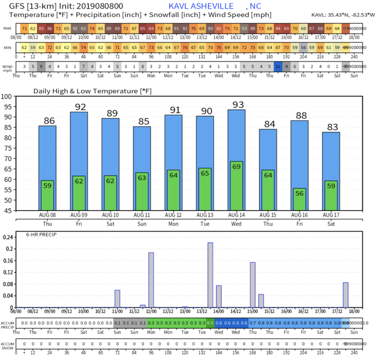
GFS Output Provided By Weathermodels.com
Contact my local trusted roofing source Matt at RedWolf Contracting Services to take care of all of your roof replacements. From shingles, to metal roofing, and even commercial rubber membrane, Matt has the resources and solutions to take care of your job in a professional and cost effective manner. Call (828) 772-9778 or visit nc-roofers.com to set up your free roof inspection.
Hydration & Sunscreen Needed
Please make sure and stay hydrated over the next 7 days. During these dry heatwaves your body needs excessive amounts of water to continue normal processes. If you are working outside, make sure to wear a hat and cover exposed areas with high SPF sunscreen. A break from the heat looks likely late next week, but we have to make it through the next several days first! Please be safe, and check on elderly neighbors to ensure they are properly cooling.


