Rare Air Set To Move Into WNC This Evening

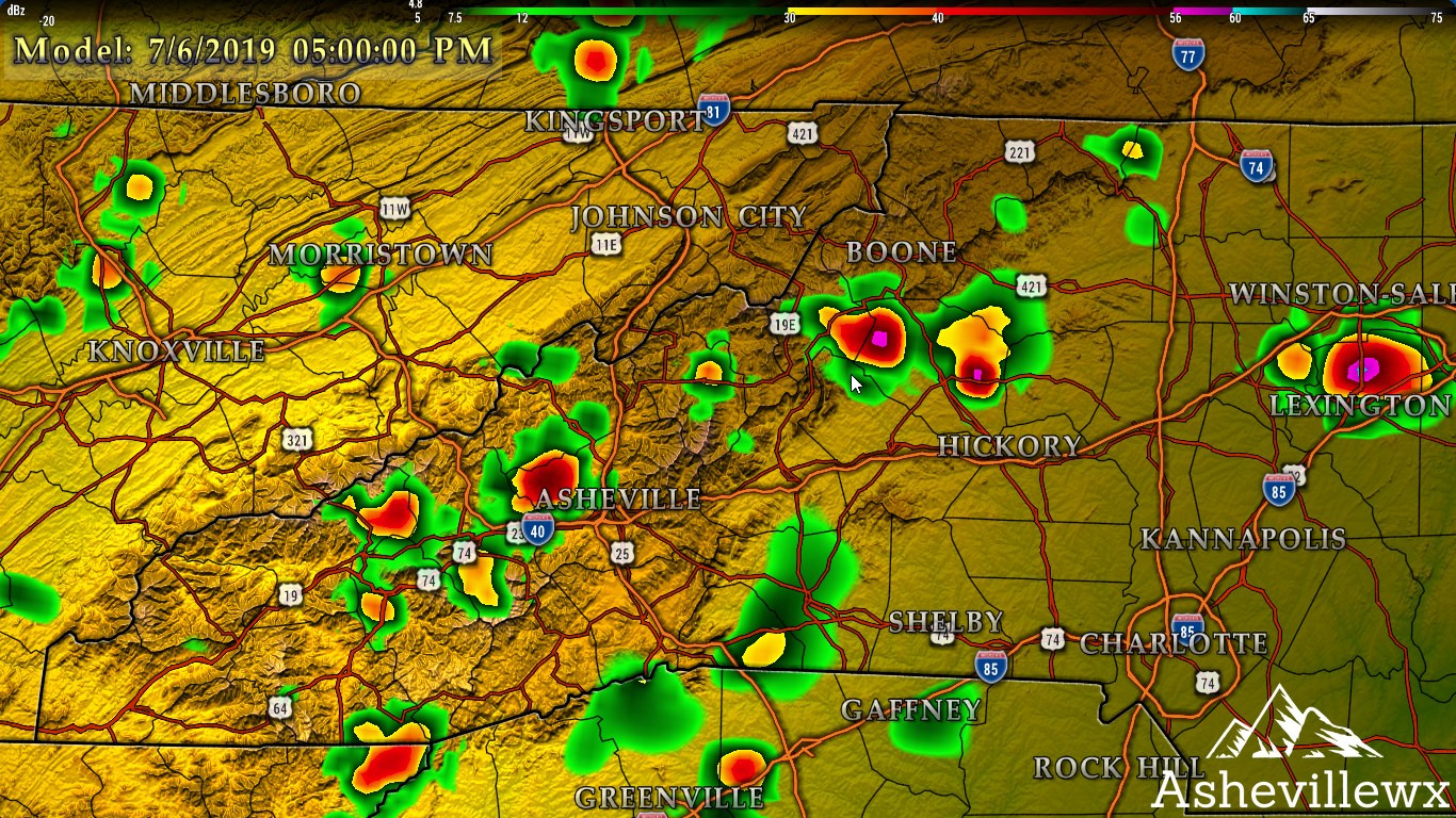
Crisp air is heading for WNC tonight, and temperatures could fall into the low 50’s or even the upper 40’s in some locations. This is very rare for WNC considering that it is the end of the July. Dew points will also dip into the 40’s which will feel fall-like around the area! Below you can see the projected temperatures per the 3km Nam tomorrow morning around WNC.

Contact my local trusted roofing source Matt at RedWolf Contracting Services to take care of all of your roof replacements. From shingles, to metal roofing, and even commercial rubber membrane, Matt has the resources and solutions to take care of your job in a professional and cost effective manner. Call (828) 772-9778 or visit nc-roofers.com to set up your free roof inspection.

Dew Points Plummet

The humidity around WNC will drop like a rock over the next 24 hours. Below you can see a simulation from the 3km Nam that shows the dew points dropping over the next day. Some areas will see a 30-40 degree temperature swing! Once again this is nearly unprecedented for late July. I don’t believe that this indicates an early Fall, but seeing these trough swing through like this is fall-like.

DewpointChangeJuly23rd.gif
Call the team that keeps my truck clean at A&R Specialist! Matt & Harley run A&R Specialist at 621 Brevard Rd. and they are the guys to trust with your vehicle cleaning & detailing. Whether you need a deep wax every once in a while o…

Call the team that keeps my truck clean at A&R Specialist! Matt & Harley run A&R Specialist at 621 Brevard Rd. and they are the guys to trust with your vehicle cleaning & detailing. Whether you need a deep wax every once in a while or a quality clean and detail, you can feel safe putting your car in the hands of A&R Specialist! Call (828) 708-3718 to set up your appointment today. https://www.facebook.com/ARpressurewashing4/

Get Out And Enjoy It!

Temperatures should only top out in the low 80’s each day for the rest of this week, so please get out and enjoy it! Start a winter garden or go for a hike! These temperatures appear to be locked in for the foreseeable future, but we are only in late July so another heatwave is certainly possible and is to be expected.

Storms Likely Again This Afternoon(Saturday) For WNC

Storms will be on tap for Western North Carolina this afternoon as daytime heat and humidity create a ripe atmosphere for development. Some locations could see isolated hail, like we have seen over the past several days. Will it happen over your house? At this point in time it’s difficult to pinpoint exactly where storms will develop, but afternoon development appears likely. Below you can see the most recent HRRR models and it indicates that two rounds of storms will be possible. The first round will occur around 1-2pm and then a second line will re-fire around 5pm.

6thOfJuly2019Radar.png
Call the team that keeps my truck clean at A&R Specialist! Matt & Harley run A&R Specialist at 621 Brevard Rd. and they are the guys to trust with your vehicle cleaning & detailing. Whether you need a deep wax every once in a while o…

Call the team that keeps my truck clean at A&R Specialist! Matt & Harley run A&R Specialist at 621 Brevard Rd. and they are the guys to trust with your vehicle cleaning & detailing. Whether you need a deep wax every once in a while or a quality clean and detail, you can feel safe putting your car in the hands of A&R Specialist! Call (828) 708-3718 to set up your appointment today. https://www.facebook.com/ARpressurewashing4/

How Much Rain Will Fall?

Some locations may only see a sprinkle, but isolated locations that get under a strong storm could very well pick up 1”+ of rainfall very quickly. Below is the most recent HRRR Model and you can see the popcorn type precipitation.

HRRR provided by weathermodels.com

HRRR provided by weathermodels.com

Contact my local trusted roofing source Matt at RedWolf Contracting Services to take care of all of your roof replacements. From shingles, to metal roofing, and even commercial rubber membrane, Matt has the resources and solutions to take care of yo…

Contact my local trusted roofing source Matt at RedWolf Contracting Services to take care of all of your roof replacements. From shingles, to metal roofing, and even commercial rubber membrane, Matt has the resources and solutions to take care of your job in a professional and cost effective manner. Call (828) 772-9778 or visit nc-roofers.com to set up your free roof inspection.

Tropics Could Be Heating Up

There has been a lot of social media buzz at the Gulf of Mexico getting active next weekend because the European model shows development, and know that I have my eye on it. It is really too far out to talk about specifics, but excessive atmospheric spin looks possible in the tropics next weekend. Some models show a stout system developing off of a cold front that sweeps across the US. For the past 4 runs the Euro has showed this, so it is something of noteworthiness, but I would like to see other models showing this same gyration. Stay tuned though, I will make sure you are kept in the know!

Strong Storms Likely This 4th of July Afternoon Around WNC

Storm development around WNC is very likely this afternoon, and some of these cells could go severe. Below you can see the most recent HRRR Model around 1pm and it shows a very stout storm developing over portions of WNC and then pushing East. These cells will likely affect the majority of WNC, and could put a damper on some initial 4th of July Festivities.

StrongJuly4thStorms.png

Those whites indicate a cell that has the possibility of producing hail, and that is what I will be watching for this afternoon. Some locations (Canton, NC) saw hail yesterday, and I believe that isolated locations will again see hail this afternoon around WNC. Its difficult to nail down exactly where the hail will actually occur, but please know that the atmosphere is ripe to produce it.

Contact my local trusted roofing source Matt at RedWolf Contracting Services to take care of all of your roof replacements. From shingles, to metal roofing, and even commercial rubber membrane, Matt has the resources and solutions to take care of yo…

Contact my local trusted roofing source Matt at RedWolf Contracting Services to take care of all of your roof replacements. From shingles, to metal roofing, and even commercial rubber membrane, Matt has the resources and solutions to take care of your job in a professional and cost effective manner. Call (828) 772-9778 or visit nc-roofers.com to set up your free roof inspection.

Will Rain Affect Fireworks?

Rain showers look to move up just before fireworks are set to begin in Downtown Asheville, but a lingering isolated shower cannot be ruled out. I expect though that the Downtown Asheville fireworks will go off without a hitch, even if there is a sprinkle in the area. You can watch the Asheville fireworks on the Grimes Teich Anderson LLP Live Downtown Asheville Camera and beat the crowds! Here is the projected 9pm radar from the most recent HRRR Model below.

Call the team that keeps my truck clean at A&R Specialist! Matt & Harley run A&R Specialist at 621 Brevard Rd. and they are the guys to trust with your vehicle cleaning & detailing. Whether you need a deep wax every once in a while o…

Call the team that keeps my truck clean at A&R Specialist! Matt & Harley run A&R Specialist at 621 Brevard Rd. and they are the guys to trust with your vehicle cleaning & detailing. Whether you need a deep wax every once in a while or a quality clean and detail, you can feel safe putting your car in the hands of A&R Specialist! Call (828) 708-3718 to set up your appointment today. https://www.facebook.com/ARpressurewashing4/

Weather Beyond Today

The theme for the next several days will be scattered showers and storms. Some locations around town last night received 2” of rainfall! Some isolated flash flooding did occur, and the chance for flash flooding again through the weekend cannot be ruled out. All models indicated that storms last night would dissipate after sunset, but that was not the case. A strong thunderstorm developed right over Asheville and created and intense light show! This will continue to be the theme as we progress through the weekend. Below is last nights precipitation totals from the rainfall.

2%22 of rain3rdofJuly.png

4th of July Forecast For WNC

Thunderstorms are back in the forecast for the majority of WNC through the weekend, with over 2” of rainfall possible through the next 5 days in some locations. Not everyone will see storms each day though, and higher elevation locations stand a better chance to see storms develop.

Call the team that keeps my truck clean at A&R Specialist! Matt & Harley run A&R Specialist at 621 Brevard Rd. and they are the guys to trust with your vehicle cleaning & detailing. Whether you need a deep wax every once in a while o…

Call the team that keeps my truck clean at A&R Specialist! Matt & Harley run A&R Specialist at 621 Brevard Rd. and they are the guys to trust with your vehicle cleaning & detailing. Whether you need a deep wax every once in a while or a quality clean and detail, you can feel safe putting your car in the hands of A&R Specialist! Call (828) 708-3718 to set up your appointment today. https://www.facebook.com/ARpressurewashing4/

4th Of July

Showers and storms will pop-up around the majority of WNC tomorrow afternoon before 5pm, but as fireworks activities begin clouds will begin to clear up! If you want to avoid the crowds you can watch the Downtown Asheville fireworks on the Grimes Teich Anderson LLP Downtown Asheville Live Camera! Below you can see the most recent Nam 3km radar at 3pm for WNC. These will develop between 1-4pm and should move out of the area by 5-6pm.

4thofJulyRadar.png
Contact my trusted roofing source Matt at RedWolf Contracting Services to take care of all of your roof replacements. From shingles, to metal roofing, and even commercial rubber membrane, Matt has the resources and solutions to take care of your job…

Contact my trusted roofing source Matt at RedWolf Contracting Services to take care of all of your roof replacements. From shingles, to metal roofing, and even commercial rubber membrane, Matt has the resources and solutions to take care of your job in a professional and cost effective manner. Call (828) 772-9778 or visit nc-roofers.com to set up your free roof inspection.

Here is a look at the 8pm projected radar per the most recent Nam 3km. As you can see a large storm complex develops coming off of the mountains, and then really blows up across portions of NC. This could put a damper on the 4th at locations in Raleigh & Greensboro, but Asheville appears to be in the clear with only a slight chance for scattered showers at showtime (9pm).

StrongLineOfStormsNC4thOfJuly.png

Heavy Rain Possible Through The Weekend In WNC

Most long range models suggest that 1-2” of rainfall will be likely around WNC through the end of the weekend. This rain will come from scattered showers and even some strong thunderstorms. Please be mindful of this when making plans for the weekend. Timing of rainfall is still uncertain at this moment, but just know that most models indicate a wet weekend! Check back soon for another update!

Second Heat Wave of 2019 Headed For Southeast Next Week

A stout ridge will develop over the Southeast next week and it will likely persist through the 4th of July weekend. Around WNC, we will likely see temperatures several afternoons reach into the low 90’s, but locations outside of the mountain and slightly farther east could push into triple digits. Below you can see the most recent European model for Tuesday afternoon. It shows 90 degrees at the Asheville Airport and nearly 100 in Charlotte.

ECMWF Temperatures Tuesday Afternoon courtesy of Weathermodels.com

Contact my trusted roofing source Matt at RedWolf Contracting Services to take care of all of your roof replacements.  From shingles, to metal roofing, and even commercial rubber membrane, Matt has the resources and solutions to take care of your jo…

Contact my trusted roofing source Matt at RedWolf Contracting Services to take care of all of your roof replacements. From shingles, to metal roofing, and even commercial rubber membrane, Matt has the resources and solutions to take care of your job in a professional and cost effective manner. Call (828) 772-9778 or visit nc-roofers.com to set up your free roof inspection.

How Long Will The Heat Wave Last?

It appears that this could be another extended heat wave where we remain relatively dry. This is good news for farmers who are wanting to get hay on the ground, because chances for rainfall over the next week will dramatically decrease compared to this past week. Isolated storms of course cannot be ruled out, so please be mindful. As you can see below on the temperature projections for Asheville from the most recent GFS, it is going to be hot!! I don’t think that 95 degrees is reasonable, but a 92 or 93 degree day could be possible mid next week.

GFS Temperature Projections Through July 6th, 2019 Courtesy of Weathermodels.com

GFS Temperature Projections Through July 6th, 2019 Courtesy of Weathermodels.com

Call the team that keeps my truck clean at A&R Specialist!  Matt & Harley run A&R Specialist at 621 Brevard Rd. and they are the guys to trust with your vehicle cleaning & detailing.  Whether you need a deep wax every once in a while…

Call the team that keeps my truck clean at A&R Specialist! Matt & Harley run A&R Specialist at 621 Brevard Rd. and they are the guys to trust with your vehicle cleaning & detailing. Whether you need a deep wax every once in a while or a quality clean and detail, you can feel safe putting your car in the hands of A&R Specialist! Call (828)708-3718 to set up your appointment today. https://www.facebook.com/ARpressurewashing4/

Will The Tropics Get Active

It doesn’t appear so. At the moment there are large amounts of Saharan dust being pushed out to sea off the African Coast by strong winds, and that will hinder any tropical development for the short term. As this dust pushes towards the US, it will also hinder any development closer to the lower 48. Many experts are projecting a very slow start to the hurricane season, but coastal areas should not let their guard down. Hurricane season persists through November so we have a long way to go.

Isolated Storms Likely Again This Afternoon Around WNC

A less active severe weather day looks to be in store for WNC compared to yesterday, but a few isolated severe cells cannot be ruled out this afternoon. Models suggest that a strong cell will pop-up somewhere over Haywood Co. and then move into Transylvania/Henderson Co. Below you can see a close-up of the projected radar at 4pm this afternoon. As you can see, that cell is rocking portions of Transylvania Co. around 4pm. Isolated hail could also be embedded in this cell, so please be mindful of that if you see these cells developing later.

HRRR Model at 4pm this afternoon

For all your residential and commercial roofing replacement needs, call my buddy Matt (828)772-9778!  He is a trusted local expert who will provide you with a free estimate to complete your job in a professional and timely manner.  Visit their websi…

For all your residential and commercial roofing replacement needs, call my buddy Matt (828)772-9778! He is a trusted local expert who will provide you with a free estimate to complete your job in a professional and timely manner. Visit their website today! nc-roofers.com

Not Everyone Will See Rainfall Today

As I stated before, these cells that pop-up will be isolated.. but could pack a strong punch if you happen to be under one. We have seen cells like that pop-up and bring large amounts of hail of locations like Brevard, and I am worried that that could happen again today. Both the Nam 3km and the HRRR show these isolated cells popping around 2-3pm so keep an eye on the radar. For the rest who don’t see rainfall, today will be nice! Sunshine should peek through the clouds and temperatures will top out in the low to mid 80’s.

Looking Ahead

Another front looks to push through the area tomorrow night, and that could bring with it another round of severe weather. Below you can see the most recent Nam 3km depiction, and it suggest that another line of storms, similar to what moved through yesterday could occur tomorrow night. Models do struggle with these events though, so there is a chance that this won’t come to fruition. It is worth nothing though, and mentioning.

Strong wind gusts, and isolated hail cannot be ruled out with the cells that move through tomorrow evening, but a number of factors will determine how strong the cells are able to get. If it remains overcast during the morning hours, and fuel isn’t allowed to build, then storm development will not be as strong. Check back tomorrow for more information regarding how the next line of storms will unfold!

Strong Storms Expected This Afternoon For WNC & The Rest Of North Carolina

Another round of strong storms is very likely this afternoon for Western North Carolina, as well as the rest of the state. A higher threat for damaging wind gusts exists in the Eastern portion of the state.. but the threat also exists for WNC. Below you can see the most recent HRRR projected radar at 6:00pm this evening. As you can see the strong line of storms is that develops slams into the mountains and then pushes out into the Foothills. Another line of storms will develop to our East, and an isolated tornado even cannot be rule out.

HRRRThursdayAfternoon6-20.png
Are you in need of  replacing your roof, but not sure who to trust with the job.  Matt at RedWolf Contracting Services is the man to call!  He will provide you with a free evaluation and estimate, and has the references to back up his good name!  Gi…

Are you in need of replacing your roof, but not sure who to trust with the job. Matt at RedWolf Contracting Services is the man to call! He will provide you with a free evaluation and estimate, and has the references to back up his good name! Give him a call (828)772-9778 to schedule your free estimate today. www.nc-roofers.com

Isolated Hail Cannot Be Ruled Out

so spotty hail is possible from these cells with the jet steam over the top of WNC. This cold pool will increase the likelihood of hail forming and making it down to the surface. The threat for hail and damaging winds increases as you move farther East and into a more favorable environment. Below you can see the current CAPE values which correlates to the amount of fuel available in the atmosphere. With high CAPE values comes strong downbursts of precipitation and strong wind gusts. The SPC has a 45% chance for damaging wind gusts for the Eastern 3rd of the State of NC.

You can see that there is considerably less CAPE in WNC compared to the rest of the state. That is due to the early morning storms that we saw today, and its affect on the environment.

RECAP

  • Damaging wind gusts, strong storms likely this afternoon in WNC

  • Threat for high wind gusts, and even isolated tornados possible later this evening across the rest of NC

  • Friday’s weather appears to be nice & mild


Strong Storms Likely Again This Afternoon/Evening Around WNC

Models indicate that another line of strong storms will form later this afternoon, and these storms will affect the majority of WNC into this evening. Lightning, heavy rain, damaging wind gusts, power outages, and even some isolated hail will be possible with these storms so please be careful. Flash flooding will also be possible on low lying roadways and in areas where storms train. Some locations received over an inch of rainfall last night, and those same locations could again see heavy rainfall, increasing the flash flooding threat. Below you can see the most recent HRRR model and is shows that strong line of storms moving through WNC around 4-5 pm this evening. If you live closer to the NC/TN border then storms will likely pop-up earlier then that.

Needing your roof replaced?  Matt of RedWolf Contracting Service is that man to call!  He has the experience and necessary to complete your job, and can provide countless references to his good name.  Give him a call (828)772-9778 to set up your fre…

Needing your roof replaced? Matt of RedWolf Contracting Service is that man to call! He has the experience and necessary to complete your job, and can provide countless references to his good name. Give him a call (828)772-9778 to set up your free roof inspection today or visit their website www.nc-roofers.com.

More Rainfall To Come

Looking ahead to the rest of this week, more rainfall/storms will be likely each afternoon. Showers and storms will be most likely Wednesday & Thursday, but an isolated shower can also not be ruled out on Friday. So we are transitioning into more of a summer-like pattern with pop-up storms on a regular basis. Check back for another update soon, and as always you can find my updated 5-day forecast here!

Rain Subsides After Today, Mild Week In Store For WNC

After rainfall moves out this evening, and this front finally passes through, a relatively mild week awaits. Temperatures will be in the mid 70’s each afternoon, and the humidity will slack off some. There will be a slight chance for rainfall each afternoon, but I do not believe that these showers will be widespread. Below you can see the low temps on Wednesday morning and you can see that it will feel very nice around WNC! Temps will fall into the low 50’s and that will be refreshing after several muggy mornings. I would consider it a back porch and coffee type morning.

Looking for a trusted roofing contractor in WNC to take care of your roofing repairs or replacement?  Have you discovered a leak in your roof during these past heavy rains and need a free roof evaluation?  Contact Matt and the team (828)772-9778 and…

Looking for a trusted roofing contractor in WNC to take care of your roofing repairs or replacement? Have you discovered a leak in your roof during these past heavy rains and need a free roof evaluation? Contact Matt and the team (828)772-9778 and let them take care of all of your roofing needs! With a trusted name, and a reputation to back it up, Matt has all the credentials to repair your roof in a cost effective, professional manner. Visit their website www.nc-roofers.com to see their work or set up an appointment!

More Rain Possible This Weekend

After a nice week, the chance for more rain comes back into the forecast for Saturday. Models Don’t show a washout just yet, but know that I have my eye on it and will keep you updated on the potential. In the meantime, enjoy the nice weather that comes after a few showers/storms this afternoon!

Widespread Southeast Flooding Possible As Tropical Moisture Moves In... 5"+ Of Rainfall Could Fall

Models continue to illustrate an extremely wet picture as we move into the weekend and into next week around the Southeast. Data suggests that some locations around the southeast could experience over 5” of rainfall over the next 6 days, and that would bring creeks and rivers out of their banks. Below you can see the most recent Weather Prediction Center’s Forecast for total precipitation through early next week.

WPC Provided by Weathermodels.com

This is a blend of all models, and really illustrates how widespread the flooding could be. Locations along the Blue Ridge Escarpment will likely receive the most amount of rainfall as the mountains wring out the tropical moisture as it streams through. I have provided below zoomed in versions on WNC of the most recent runs of the GFS & Euro. As you can see the Euro is still much more bullish on total amounts of rainfall.. but totals continue to steady rise on the GFS.

ECMWF Provided by Weathermodels.com

Need a trusted local contractor to handle your roofing needs?  Call Matt at (828)772-9778 to set up your free roof evaluation and estimate today!  nc-roofers.com

Need a trusted local contractor to handle your roofing needs? Call Matt at (828)772-9778 to set up your free roof evaluation and estimate today! nc-roofers.com

GFS Provided By Weathermodels.com

As you can see the GFS shows half the amount of precip compared to the Euro, but the GFS has been moving higher with rainfall totals over the past several runs. On the other hand, the Euro has been steady with projecting 5”+ of rainfall for Asheville. It has shown that for the past several runs, and needs to be taken seriously. When precipitation maximums begin to show up on the Blue Ridge Escarpment with 10”+, that is a huge red flag to me. This tropical moisture will linger for days, and could really create a mess for WNC. I will update again when new data become available, check back soon for another update!