


As we continue to track the approaching storm, models are beginning to resolve small details in the atmosphere. A warm nose aloft at 700mb will melt precipitation as it falls through that layer. Then that precipitation will fall through a layer of frozen air very close to the surface. This will produce a combo of sleet and freezing rain for most. Locations west of Asheville will be warmer aloft and as you move towards Sylva and Franklin, the chance for frozen precipitation will dramatically decrease. It cannot be ruled out though. Locations around Henderson Co. where cold air from the wedge will be more prevalent could see significant icing. This includes most all locations along the Blue Ridge Escarpment. The chance for snowfall will occur at the beginning of heavy precipitation when dry air will allow temperatures to wet bulb in the atmosphere. I believe that many will see a dusting or so before switching to sleet or freezing rain. If models are correct, some locations could see over .25” of ice, and power outages could become a problem. Join me live tonight at 8pm in the AshevilleWx App or shortly after that on Facebook live where I will detail out my latest thoughts on the approaching event.
Wintry Mix Likely Tuesday Evening Around WNC Before Switchover To Rain Early Wednesday
A strong overrunning piece of moisture will move through WNC beginning on Tuesday, and as heavy precipitation moves in Tuesday evening, many could switchover to sleet or snow. Models continue to change each run with small, but important changes. I am tracking the warm nose at 700mb high in the atmosphere, and that will determine if heavy snow falling through that layer will melt or not. This layer is the warmest layer in the atmosphere Tuesday evening, and will determine if precipitation falls as rain/sleet/or snow for your area. Our cold air is going to be provided by a high pressure to the northeast and as that cold wedge sets up, just how far SW into WNC its pushes has yet to be determined. Below you can see my initial forecast map regarding how I think Tuesday night and into Wednesday will unfold. Eventually Wednesday morning most locations will switch over to only rain.. but cold air damming events can be stubborn and more prolonged compared to what models project. This map is subjected to change over the next 48 hours but I wanted to give you an idea of my thoughts moving forward. Join me live tonight in the AshevilleWX App at 7:30pm where I will detail out the most recent model data, and give my my current thoughts on the approaching event.

Tax Time Is Now
Trust the pros on Hendersonville Highway will all of your tax needs! They are the best in town! Call (828)684-7374 or visit kruseaccounting.com to set up your appointment today!
Flash Flooding Threat Increasing
Long range models continue to paint a scary picture regarding the amount of precipitation that will move through the southeast over the next week. Many of the models believe that some locations could see over 10” of rainfall through next Sunday. This will most certainly cause streams and rivers to come out of their banks around the area, so please make preparations and be mindful that flooding is a real possibility next week. Below is the most recent 7 day precipitation total projection map from the GFS.
12z GFS Precipitation totals courtesy of Weathermodels.com
Join me live tonight at 7:30pm in the AshevilleWX App as I discuss the next week in weather!

Chance For Wintry Weather Increasing For WNC On Tuesday Night, Above 3500' Could Get Hammered
I have had my eye on this system for the past week, and models are finally beginning to come towards a consensus. It appears that a strong area of overrunning precipitation will push into WNC sometime on Tuesday, and that will meet a cold wedge of air that will be funneled in from the Northeast. What does appear certain over the next week is heavy precipitation. Over 5” of rain will be possible later next week, but my current focus is on resolving the details of when the precipitation begins on Tuesday.
What Details Need To Be Worked Out?
Precipitation Timing
When will the system move in from the South, and how strong will the wedge be? If the wedge is allowed to build into the night on Tuesday before precipitation moves in, I think we stand a better chance of seeing accumulating snowfall around WNC. If it comes in during the day on Tuesday, I think the chance of us switching to snow will dramatically decrease.
Strength of Cold Wedge
As high pressure builds to our NE during the day on Tuesday, cold air will infiltrate the surface layer around WNC. Some models show this near frozen layer much deeper compared to others. Depending on the exact positing of when the high pressure sets up and its orientation, will determine just how much cold air is available.
Rate of Precipitation
Heavy precipitation will cause the column of air above WNC to go isothermal(frozen) sometime Tuesday evening. Depending on how heavy this precipitation is will determine how long we will see mixing (if any). Some models bring as much as 1” of rain in a six hour period Tuesday evening. Wetbulbing could occur where dry air allows precipitation to stay frozen as it falls through near frozen air. This is the natural atmospheric process that I believe could produce snowfall at the onset of precipitation Tuesday evening.
Model Data:
Below you can see a sounding from the 12z GFS that shows the column of air around Asheville. I have circled the crucial area where the temperature barely rises above freezing. This is what I am watching regarding the possibility for heavy snow/sleet Tuesday night.

Tax Time Is Now!
It’s tax time again, so why not trust the best in the area at C.P. Kruse & Co. Call them today (828)684-7374 or visit their website http://www.kruseaccounting.com
Below is the 12Z GFS precipitation depiction and it shows the transition just northeast of Asheville. Temperatures are so borderline, that we will need to wait until short range models get into range to have a better idea as to if accumulation around Asheville will be possible.
12z GFS Precipitation Depiction Courtesy of Weathermodels.com
Elevation Above 3500’ Look To Get Hammered With Heavy Snow Tuesday Night
I am more confident that higher elevation locations in WNC above 3500’ will see heavy snow Tuesday night. Accumulation will certainly be possible as well, with some models showing an astonishing 12”+ around Boone before a switchover to rain. There is great volatility with models currently, and very small details within these models can change over the next few days. Thats why I am watching the front of this moisture stream very closely.
Extreme Flash Flooding Possible Late Next Week/Next Weekend
I am becoming increasingly concerned about the flash flooding potential later next week as this stream of moisture brings over 5” of precipitation to the area. Already soggy soil will not handle the excessive moisture that the atmosphere will bring next week, and that will cause problems all across the SE. Some locations in NGA and SWNC could see over 10” of rainfall in the next 7-8 days. That will push streams and rivers out of their banks, so if you live in these areas next to a creek.. please be prepared to move to higher ground. Below you can see the most recent GFS total precipitation model for the next 7 days.
12z GFS Total Precipitation Courtesy of Weathermodels.com
Recap:
Some higher elevation sleet/freezing rain could be possible tomorrow night above 3500’
Rain likely for others below 3500’, a few sleet pellets cant be ruled out
Next system moves in Tuesday afternoon, heavy precipitation Tuesday night could turn to snow
Higher elevations above 3500’ in WNC will switch to snow and 3”-6” of snow could be possible
Accumulating snowfall cannot be ruled out below 3500’, short range models will be needed
Next system moves in next weekend, and could push weekly precipitation totals above 5”
Dangerous flash flooding will be possible to end the week, especially SW of Asheville
Join me live tonight at 8pm on Facebook and the AshevilleWX App for another update
Soggy Weekend In Store For WNC This Weekend
Today and tomorrow around WNC should be beautiful, but winds could be gusty in some locations. Looking ahead towards the weekend, I have my eye on two separate storms that will bring rainfall to the area. The first will move in on Saturday morning and should persist through the early afternoon. I am expecting around a half inch of rainfall for most from this system. Then another system will push through on Sunday and into Monday where a half inch to 1” of rainfall will be possible. Some isolated flash flooding cannot be ruled out with this rainfall, so please be mindful of that.

Beat The Rush
Schedule your personal or business tax appointment today with the local professionals at C.P. Kruse & Co. Call (828)684-7374 or visit their website www.Kruseaccounting.com
More Precipitation On The Way
Following this weekend, it appears that we will move back into a wetter pattern (did we ever get out of it?). On Tuesday another system of overrunning precipitation will affect WNC. Some models have had wintry precipitation associated, but others are too warm. The cold air for this system would be provided by Cold Air Damming and some models believe the cold wedge will be stronger compared to others. A lot of uncertainty still remains with this system which is why I have chosen to focus right now on the precipitation amounts instead of snowfall potential. Over 3” of rainfall looks possible by this time next week, and that will increase the flash flooding potential around WNC. Streams will rise over the weekend, and won’t have much of an opportunity to recede since these systems will be back to back to back. Below you can see the projected precipitation totals through mid next week per the most recent GFS. You can see that areas to the SW of Asheville stand a much better chance of seeing excessive rainfall, but widespread 2.5” totals are possible with these three combined precipitation events.
12z GFS Precipitation Map Courtesy of Weathermodels.com
Will There Be Snow With The Last System?
Some long range models have shown the potential for wintry weather next Tuesday, and that cannot be ruled out.. but temperatures are going to be very close. Depending on how strong the high pressure to our north is will determine how strong of a cold wedge sets up. Join me live tonight at 8pm in the AshevilleWX App as I discuss the coming week in weather, and give you my latest thoughts on early next week!
Heavy Rain/Thunderstorms Possible Around WNC This Afternoon
a strong line of storms is developing in Eastern TN and will move into WNC this afternoon. Some lsolated flash flooding cannot be ruled out with this system with over 1” of rainfall expected through the evening. Higher elevations above 3500’ on the NC/TN will see snow showers early Wednesday morning, but I don’t think anything more then a stray flurry will be possible around Downtown Asheville. The main story with this system will be the return to cold and the chance for some thunder as the system moves through.

Long Range GFS Indicates Snow Next Week
There has been some rumblings of a snowstorm around WNC next week, and I have my eye on the potential. It is still to far out to discuss it in too much detail though because there is very little model consensus. Both the Euro and Canadian models show the system but are too warm for snow. I look for a these to come to some agreement over the next few days and we could be looking at two separate storms. Stay tuned, I will update when the picture becomes a bit more clear!

It’s tax season and if you are looking for the best in WNC to take care of your taxes call C.P. Kruse! (828)684-7374 or visit their website Kruseaccounting.com
Rain Expected Early This Week Around WNC, Then A Cold Front Move Through On Wednesday
Scattered showers are already moving into WNC currently, and will continue through the next couple of days as a strong front makes it way through the area. Some sleet cannot be ruled out today at the onset of precipitation, especially at higher elevations closers to Boone.. but the impacts will be minimal.
Heavier Rain Expected Tuesday
As this front moves through the Midwest, a line of storms will develop on Tuesday.. and could bring some thunderstorms to WNC later in the day on Tuesday. Many locations will receive over 1” of rainfall from this line, and isolated flash flooding could become a concern. Below you can see the most recent GFS total precipitation map through Wednesday morning. Most locations receive around 1” will less as you progress north of Asheville. Locations like Franklin & Andrews have a better chance to see flash flooding with models showing enhanced precipitation across those locations through Wednesday morning.
GFS Precip Total Thru Wednesday AM Courtesy of Weathermodels.com

Don’t Sweat Tax Season
Set up your appointment today with the best tax professionals in town! Call C.P. Kruse & Co. at (828)684-7374 or visit their website http://www.kruseaccounting.com to schedule your time slot today!
Snow Showers Possible Wednesday AM
After the front passes, winds will pick up and gust over 30 mph around Asheville, and some flurries cannot be ruled out as temperatures plummet. High temps on Wednesday will barely push into the 40’s and the wind chill will be in the teens. No significant accumulation is expected from these snow showers, but it still too far out to tell if a dust will be possible around Asheville. Stay tuned for another update, and have a great Sunday!
Check out the current weather on our WNC Webcams!
Wintry Mix Possible Early Saturday & Again Sunday Around WNC
A wintry mix cannot be ruled out early tomorrow morning as overrunning precipitation from a weak front located in Texas move through WNC. Dew points will make this a tricky forecast because surface temperatures will be below freezing, and upper level temperatures will be above freezing. Depending on how much dry air exist between the surface and warm temps will determine how much dynamic cooling occurs. Dynamic cooling or evaporational cooling occur when moisture descends down a column of air that is not completely saturated. As the dry air around it absorbs the moisture as it falls, a natural cooling occurs. This is how snowflakes make it through layers of air that are not completely frozen. I think this type of setup will occur early tomorrow morning, and could bring some surprise snow flurries to many in the area. Models are struggling to resolve this solution, but when these baroclinic zones develop between two areas of high pressure and the zone is directed towards WNC.. upslope flow throws models off.

Trust The Tax Pros
C.P. Kruse & Co. can take the stress out of tax season, all while getting you your maximum refund! Don’t sweat the IRS, call C.P. Kruse (828)684-7374 or visit http://www.kruseaccounting.com
Effects?
I am hesitant to believe that we will see too much of an impact from this system, but some ice accumulation cannot be ruled out. If precipitation is heavy enough, some could see bursts of snow, and an isolated dusting is possible.
Timing?
Late Friday night and into Saturday morning will be the first round, and then another round will be possible as a cold wedge builds in during the morning Sunday. These appear to be relatively low impact events because roadways are warm.. but looking downstream, the NWS in Texas had to issue Winter Weather Advisories after the fact because roadway conditions deteriorated today as ice/freezing rain/snow fell. Please make sure to report anything you see to the AshevilleWX Weather Community on Facebook and check back soon for another update!
Record High Temps Possible Today Then Cooler Temperatures Return To WNC This Weekend, Freezing Drizzle Cannot Be Ruled Out Saturday Morning
It has been a gorgeous week around Western North Carolina, and that will continue today as many locations push for record high temperatures. I am forecasting a high temperature of 71 which would tie the record high for February 7th, but many locations will rise even higher than that this afternoon! Some scattered showers could be possible late, but nothing more than .25” or precipitation is expected. Looking ahead to the weekend, we will cool down considerably as this front moves through. Temperatures will dip into the 20’s Saturday morning at the surface, and some overrunning precipitation could advect out well in front of a surface low located in Texas.
Freezing Drizzle Cannot Be Rule Out
I could see the potential for some slight icing, especially along the southern portion of The Blue Ridge Escaprment, but surface temperatures will be moderate since we have been so warm lately. Therefore, I am not overly concerned about this potential, but it is noteworthy that the possibility exists. I have my eye on short range models, and below you can see the most recent NAM 3km, and how it depicts moisture moving in over a frozen column. Depending on how high dew points are around WNC, will determine if the precipitation actually makes it to the surface. If it does, surface temps Saturday morning will be in the upper 20’s and elevated surfaces could see some form of light ice accretion.

Nam 3km Simulated Radar For Saturday at 8am Courtesy of Weathermodels.com

Tax Season Is Here
Bring your personal or business taxes to the local pros at C.P. Kruse & Co. located on Hendersonville Hwy! Give them a call today to set up your appointment! (828)684-7374 http://www.kruseaccounting.com

Projected Temps Saturday Morning At 8am Per 3km Nam Courtesy of Weathermodels.com
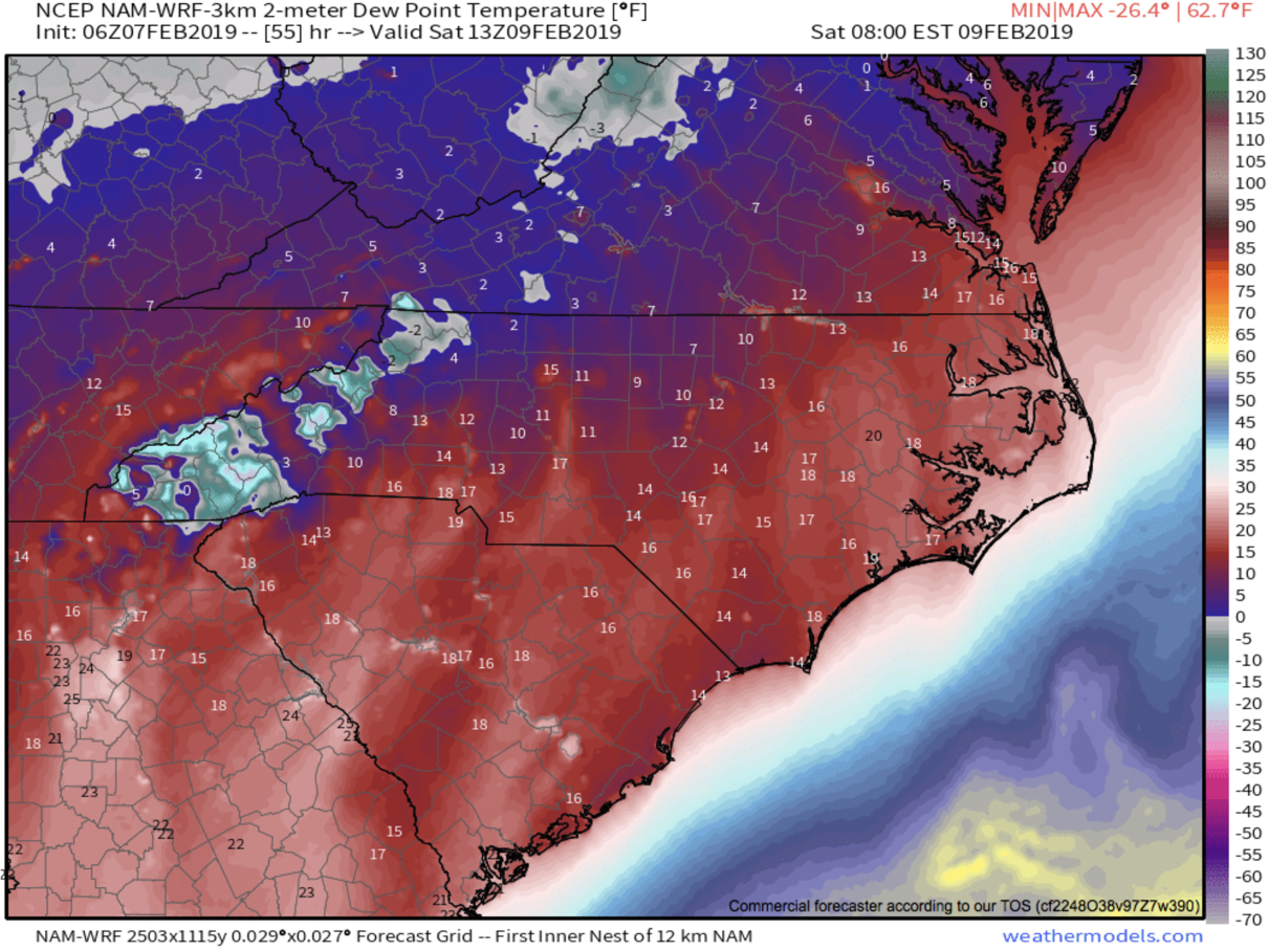
Projected Dew points Saturday at 8am per 3km Nam courtesy of Weathermodels.com
As you can see those are some very low dew points so it is very questionable as to whether or not this moisture makes it to the surface. I will be watching these dew points over the next two days to see if they increase. If they do, then the likelihood of precipitation making it to the frozen surface will increase. I believe we could see light moisture again move in Sunday morning as temps dip below freezing. These small scale icing events are poorly modeled in many cases, especially around WNC.. so join me live tonight in the AshevilleWX App at 8pm where I will detail out my thoughts on the potential, and what the most recent models show!
Spring-Like Temps, Highs Close To 70 Likely Around WNC Early Next Week, But Cold Returns Next Weekend
The thaw out begins now! Locations around WNC over the next few days will feel Spring-like with temperatures pushing into the low 60’s most afternoons, and even into the low 70’s on Tuesday. The next round of rain looks to move in late Tuesday or early Wednesday, but these only appear to be scattered showers will minimal impacts. So all and all the next 5-7 days appear to be calm, mild days around WNC! I for one is happy to see the cold subside. Frozen ground makes for difficult digging, and as many of you know I am a Home Builder, so the cold weather works against my agenda. Next week though will be perfect for outdoor projects! Other then a bit of rain on Wednesday, it looks ideal for progress!
GFS Surface Temps Tuesday Afternoon Courtesy of Weathermodels.com

Why Stress?
Let the local WNC tax pros at C.P. Kruse & Co. take care of all your tax needs this year! Call them at (828)684-7374 or visit http://www.kruseaccounting.com
Cold Returns Next Weekend
Looking ahead at long range models, and they finally break down this persistent ridge that will send warm air our way by next weekend. A strong frontal passage looks to be on the table for late next week, and that will bring back cold temperatures to the majority of the East Coast. Cold blocking moves in to our north, and low pressures set up on the Mexico/TX border, placing NC right in the area of truncation. With high pressure persistent in the Caribbean, two areas of higher pressure will meet and create some sort trough. How this unfolds is still of course very blurry, but the return to cold does look certain. Join me tonight at 8pm in the AshevilleWX App and I will detail out my thoughts on this pattern!

GFS Model For Late Saturday Next Weekend Courtesy of Tropicaltidbits.com
Mild Weekend Ahead With Temperatures In The Upper 50's Around WNC
The cold air finally eases off over the next couple of days around WNC and we will finally begin to thaw out somewhat. A few scattered showers cannot be ruled out tomorrow, but I main expect partly cloudy skies for most. Temperatures will rise into the mid to upper 50’s on both Saturday & Sunday so get out and enjoy the warm weather! Into next week we continue to thaw with temperatures on Monday and Tuesday even rising close to 60 degrees! The cold will return though next weekend! For now though my main focus is on mild temperatures and sunshine. This appears to be a nice halftime for winter, and an active pattern does appear to return mid February. Below are the temperatures for Saturday afternoon. Mid 50’s will feel nice compared to highs in the upper 30’s. If you work outdoors, next week appears to be a good week for progress.. If you are pouring concrete try and schedule for Monday or Tuesday. Have a great weekend, and check back later for more updates!
3km Nam temperatures for Saturday afternoon courtesy of Weathermodels.com

Tax Stress?
Don’t sweat it! C.P. Kruse & Co. are the local professionals that you should trust with your tax needs. They are the best in WNC! Call today (828)684-7374 or visit their website http://www.kruseaccounting.com
