Heavy Rain/Thunderstorms Possible Around WNC This Afternoon

a strong line of storms is developing in Eastern TN and will move into WNC this afternoon.  Some lsolated flash flooding cannot be ruled out with this system with over 1” of rainfall expected through the evening.  Higher elevations above 3500’ on the NC/TN will see snow showers early Wednesday morning, but I don’t think anything more then a stray flurry will be possible around Downtown Asheville.  The main story with this system will be the return to cold and the chance for some thunder as the system moves through.  

FullSizeRender.jpg

Long Range GFS Indicates Snow Next Week

There has been some rumblings of a snowstorm around WNC next week, and I have my eye on the potential.  It is still to far out to discuss it in too much detail though because there is very little model consensus.  Both the Euro and Canadian models show the system but are too warm for snow.  I look for a these to come to some agreement over the next few days and we could be looking at two separate storms.   Stay tuned, I will update when the picture becomes a bit more clear! 

It’s tax season and if you are looking for the best in WNC to take care of your taxes call C.P. Kruse!  (828)684-7374 or visit their website Kruseaccounting.com 

It’s tax season and if you are looking for the best in WNC to take care of your taxes call C.P. Kruse!  (828)684-7374 or visit their website Kruseaccounting.com 

Rain Expected Early This Week Around WNC, Then A Cold Front Move Through On Wednesday

Scattered showers are already moving into WNC currently, and will continue through the next couple of days as a strong front makes it way through the area. Some sleet cannot be ruled out today at the onset of precipitation, especially at higher elevations closers to Boone.. but the impacts will be minimal.

Heavier Rain Expected Tuesday

As this front moves through the Midwest, a line of storms will develop on Tuesday.. and could bring some thunderstorms to WNC later in the day on Tuesday. Many locations will receive over 1” of rainfall from this line, and isolated flash flooding could become a concern. Below you can see the most recent GFS total precipitation map through Wednesday morning. Most locations receive around 1” will less as you progress north of Asheville. Locations like Franklin & Andrews have a better chance to see flash flooding with models showing enhanced precipitation across those locations through Wednesday morning.

GFS Precip Total Thru Wednesday AM Courtesy of Weathermodels.com

Don’t Sweat Tax Season

Set up your appointment today with the best tax professionals in town! Call C.P. Kruse & Co. at (828)684-7374 or visit their website http://www.kruseaccounting.com to schedule your time slot today!

Snow Showers Possible Wednesday AM

After the front passes, winds will pick up and gust over 30 mph around Asheville, and some flurries cannot be ruled out as temperatures plummet. High temps on Wednesday will barely push into the 40’s and the wind chill will be in the teens. No significant accumulation is expected from these snow showers, but it still too far out to tell if a dust will be possible around Asheville. Stay tuned for another update, and have a great Sunday!

Check out the current weather on our WNC Webcams!

Wintry Mix Possible Early Saturday & Again Sunday Around WNC

A wintry mix cannot be ruled out early tomorrow morning as overrunning precipitation from a weak front located in Texas move through WNC. Dew points will make this a tricky forecast because surface temperatures will be below freezing, and upper level temperatures will be above freezing. Depending on how much dry air exist between the surface and warm temps will determine how much dynamic cooling occurs. Dynamic cooling or evaporational cooling occur when moisture descends down a column of air that is not completely saturated. As the dry air around it absorbs the moisture as it falls, a natural cooling occurs. This is how snowflakes make it through layers of air that are not completely frozen. I think this type of setup will occur early tomorrow morning, and could bring some surprise snow flurries to many in the area. Models are struggling to resolve this solution, but when these baroclinic zones develop between two areas of high pressure and the zone is directed towards WNC.. upslope flow throws models off.

Trust The Tax Pros

C.P. Kruse & Co. can take the stress out of tax season, all while getting you your maximum refund! Don’t sweat the IRS, call C.P. Kruse (828)684-7374 or visit http://www.kruseaccounting.com

Effects?

I am hesitant to believe that we will see too much of an impact from this system, but some ice accumulation cannot be ruled out. If precipitation is heavy enough, some could see bursts of snow, and an isolated dusting is possible.

Timing?

Late Friday night and into Saturday morning will be the first round, and then another round will be possible as a cold wedge builds in during the morning Sunday. These appear to be relatively low impact events because roadways are warm.. but looking downstream, the NWS in Texas had to issue Winter Weather Advisories after the fact because roadway conditions deteriorated today as ice/freezing rain/snow fell. Please make sure to report anything you see to the AshevilleWX Weather Community on Facebook and check back soon for another update!

Record High Temps Possible Today Then Cooler Temperatures Return To WNC This Weekend, Freezing Drizzle Cannot Be Ruled Out Saturday Morning

It has been a gorgeous week around Western North Carolina, and that will continue today as many locations push for record high temperatures. I am forecasting a high temperature of 71 which would tie the record high for February 7th, but many locations will rise even higher than that this afternoon! Some scattered showers could be possible late, but nothing more than .25” or precipitation is expected. Looking ahead to the weekend, we will cool down considerably as this front moves through. Temperatures will dip into the 20’s Saturday morning at the surface, and some overrunning precipitation could advect out well in front of a surface low located in Texas.

Freezing Drizzle Cannot Be Rule Out

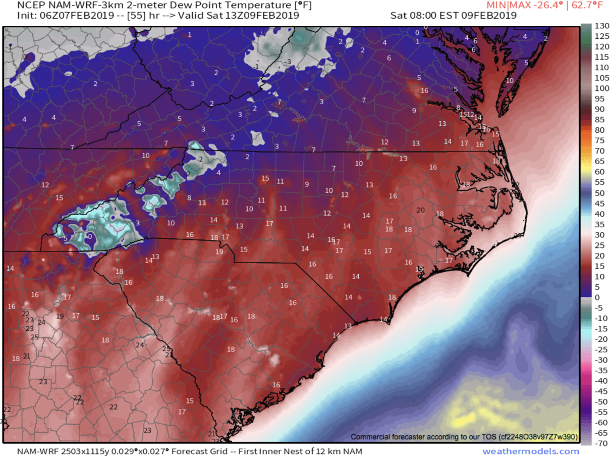
I could see the potential for some slight icing, especially along the southern portion of The Blue Ridge Escaprment, but surface temperatures will be moderate since we have been so warm lately. Therefore, I am not overly concerned about this potential, but it is noteworthy that the possibility exists. I have my eye on short range models, and below you can see the most recent NAM 3km, and how it depicts moisture moving in over a frozen column. Depending on how high dew points are around WNC, will determine if the precipitation actually makes it to the surface. If it does, surface temps Saturday morning will be in the upper 20’s and elevated surfaces could see some form of light ice accretion.

Nam 3km Simulated Radar For Saturday at 8am Courtesy of Weathermodels.com

Nam 3km Simulated Radar For Saturday at 8am Courtesy of Weathermodels.com

Tax Season Is Here

Bring your personal or business taxes to the local pros at C.P. Kruse & Co. located on Hendersonville Hwy! Give them a call today to set up your appointment! (828)684-7374 http://www.kruseaccounting.com

Projected Temps Saturday Morning At 8am Per 3km Nam Courtesy of Weathermodels.com

Projected Temps Saturday Morning At 8am Per 3km Nam Courtesy of Weathermodels.com

Projected Dew points Saturday at 8am per 3km Nam courtesy of Weathermodels.com

Projected Dew points Saturday at 8am per 3km Nam courtesy of Weathermodels.com

As you can see those are some very low dew points so it is very questionable as to whether or not this moisture makes it to the surface. I will be watching these dew points over the next two days to see if they increase. If they do, then the likelihood of precipitation making it to the frozen surface will increase. I believe we could see light moisture again move in Sunday morning as temps dip below freezing. These small scale icing events are poorly modeled in many cases, especially around WNC.. so join me live tonight in the AshevilleWX App at 8pm where I will detail out my thoughts on the potential, and what the most recent models show!

Spring-Like Temps, Highs Close To 70 Likely Around WNC Early Next Week, But Cold Returns Next Weekend

The thaw out begins now! Locations around WNC over the next few days will feel Spring-like with temperatures pushing into the low 60’s most afternoons, and even into the low 70’s on Tuesday. The next round of rain looks to move in late Tuesday or early Wednesday, but these only appear to be scattered showers will minimal impacts. So all and all the next 5-7 days appear to be calm, mild days around WNC! I for one is happy to see the cold subside. Frozen ground makes for difficult digging, and as many of you know I am a Home Builder, so the cold weather works against my agenda. Next week though will be perfect for outdoor projects! Other then a bit of rain on Wednesday, it looks ideal for progress!

GFS Surface Temps Tuesday Afternoon Courtesy of Weathermodels.com

Why Stress?

Let the local WNC tax pros at C.P. Kruse & Co. take care of all your tax needs this year! Call them at (828)684-7374 or visit http://www.kruseaccounting.com

Cold Returns Next Weekend

Looking ahead at long range models, and they finally break down this persistent ridge that will send warm air our way by next weekend. A strong frontal passage looks to be on the table for late next week, and that will bring back cold temperatures to the majority of the East Coast. Cold blocking moves in to our north, and low pressures set up on the Mexico/TX border, placing NC right in the area of truncation. With high pressure persistent in the Caribbean, two areas of higher pressure will meet and create some sort trough. How this unfolds is still of course very blurry, but the return to cold does look certain. Join me tonight at 8pm in the AshevilleWX App and I will detail out my thoughts on this pattern!

GFS Model For Late Saturday Next Weekend Courtesy of Tropicaltidbits.com

GFS Model For Late Saturday Next Weekend Courtesy of Tropicaltidbits.com

Mild Weekend Ahead With Temperatures In The Upper 50's Around WNC

The cold air finally eases off over the next couple of days around WNC and we will finally begin to thaw out somewhat. A few scattered showers cannot be ruled out tomorrow, but I main expect partly cloudy skies for most. Temperatures will rise into the mid to upper 50’s on both Saturday & Sunday so get out and enjoy the warm weather! Into next week we continue to thaw with temperatures on Monday and Tuesday even rising close to 60 degrees! The cold will return though next weekend! For now though my main focus is on mild temperatures and sunshine. This appears to be a nice halftime for winter, and an active pattern does appear to return mid February. Below are the temperatures for Saturday afternoon. Mid 50’s will feel nice compared to highs in the upper 30’s. If you work outdoors, next week appears to be a good week for progress.. If you are pouring concrete try and schedule for Monday or Tuesday. Have a great weekend, and check back later for more updates!

3km Nam temperatures for Saturday afternoon courtesy of Weathermodels.com

Tax Stress?

Don’t sweat it! C.P. Kruse & Co. are the local professionals that you should trust with your tax needs. They are the best in WNC! Call today (828)684-7374 or visit their website http://www.kruseaccounting.com

Some Icy Roads Will Develop Around WNC Tonight As Temps Drop Into Teens/Winds Gust, Flurries Possible Again Wednesday

After a brief few hours of precipitation across WNC this afternoon.. temperatures will plummet into the teens and winds will pick up significantly. Wet roadways could turn icy as these temperatures rapidly fall. Please use caution if you are traveling around the area after the sun sets. Temperatures tomorrow will struggle to push above freezing, so limit outdoor exposure if possible! Some snow flurries/showers are likely on the TN/NC border Wednesday morning, and those flurries could even push into Asheville and surrounding areas with winds gusting over 30mph. Join me live tonight at 8pm in the AshevilleWX App where I will detail out my expectations for this backside northwest flow moisture. Below you can see the most recent NAM 3km temperature chart, and it shows temperatures in the upper teens at the Asheville Airport around Midnight. Please bring pets in, and go through the necessary precautions to secure your water sources don’t freeze up. Stay safe, and check back soon for another update!

12z 3km Nam temperature output at Midnight Tonight Courtesy of Weathermodels.com

12z 3km Nam temperature output at Midnight Tonight Courtesy of Weathermodels.com

April Is Coming

Get a jump on your taxes with the trusted local pros at C.P Kruse & Co. Give them a call at (828)684-7374 or visit their website at http://www.kruseaccounting.com

AshevilleWX Projected Snowfall Totals For Tuesday January 29th

A strong arctic front will push through the Southeast beginning late tonight in the highest elevations of WNC. Moisture will flow into the valleys below shortly after, and that rain should switch to snow by daybreak. I believe a dusting to 2” will be possible for most locations around Western North Carolina, with higher totals along the NC/TN border. Roadways could become slick early tomorrow morning, so please use caution when traveling around the area. Some lee side redevelopment will occur as the front pushes across NC, and that will drop snow on some central and northerner NC counties as well. Below you can see my projected snowfall map. Join me live in the AshevilleWX App tonight at 8pm as I discuss how the storm will unfold, and what the most recent model updates show!

The Local Tax Pro’s

Set up your tax appointment today with the local best! Call (828)684-7374 or visit http://www.kruseaccounting.com

AshevilleWXSnowforecastJan29thsmall.png

Snowstorm Possible Tuesday Into Wednesday Around WNC Next Week

Extremely cold temperates are on the way for the area, and accompanying those temperatures could be gulf moisture. As the polar vortex fractures, these lobes will move down into the United States, and the cold air that is associated will also move through. Most major global models have an arctic front moving in Tuesday evening with snowfall developing behind. These type system can be referred to as anafronts since they are a-typical. Usually moisture develops out in front of cold fronts, but in rare cases with so arctic fronts moisture can develop behind. That is what many of the models have been keying on. So for the weekend we have the chance of a few snow flurries Sunday as a weak clipper systems move through. Then all eyes will focus on the next arctic front and how it interacts with the Gulf. Models have been struggling greatly with this upcoming pattern, so a multitude of solutions are still on the table. so bear with me through the duration. Below you can see the most recent snowfall map produced by the European model.

12z Euro Snowfall courtesy of Weather.us

The Local Tax Team

Why both with Tax Prep chains this year? Support your local tax experts at C.P. Kruse and make an appointment today! Call (828)684-7374 or visit their website http://www.kruseaccounting.com

The GFS also shows this development as you can see below.

12z GFS Precipitation Depiction Courtesy of Weathermodels.com

An anafront allows moisture to fall post frontal passage. The depiction below is from NCSU and shows how unlike a typical frontal passage, moisture is allowed to fall into the cold region of the storm. Usually we experience what are considered Katafronts, but this systems appears to be an anafront, and not just cold chasing moisture. Join me tonight at 8pm live in the AshevilleWX App as I discuss the possibilities, or tune in on Facebook live shortly after!

Anafront.gif

Snow Showers Possible Sunday Around WNC

A clipper system will push through WNC on Sunday, bringing with it cold temperatures, gusty winds, and even some snow showers for many in Western North Carolina. Short range models are just beginning to resolve this solution, but as we progress towards Sunday, I expect to have a better idea of how much if any snow will accumulate. Surface temperatures may rise close to 40 on Sunday around Asheville, but upper level temperatures will be very cold, so that increases the likelihood that flakes will not melt as they approach the valley surface. Most models show very limited if any accumulation with this event, but sometimes with these smaller events here in WNC, the models struggle to resolve the solution until 24-36 hours out. So what you should take away from this, is that windy conditions are likely today as temperatures fall throughout the day. Snow showers can’t be ruled in the higher elevations through Friday. Then a clipper system will move through the area beginning Sunday. Join me live in the AshevilleWX App at tonight at 8pm for a discussion of what the most recent models show, and my thoughts on how the event will progress!

6z Nam Precipitation Depiction Early Sunday Afternoon Courtesy of Pivotalweather.com

The Local Tax Pro’s

Looking for trusted local tax professionals who treat you like family? C.P. Kruse & Co. is your answer! Call them today (828)684-7374 or visit their website http://www.kruseaccounting.com to set up your appointment today!