Freezing Rain Possible Around WNC Late Tuesday Into Wednesday

Precipitation out in front of a strong low pressure will push into a deep wedge that entrenched over the Southeast beginning late Tuesday night, and will persist through the early hours of Wednesday morning. Upper level temperatures do not appear to be supportive for snowfall, but a layer of frozen air looks to develop between the surface and 5000’. This could be very problematic because of how cold the surface will be when this precipitation moves in. So locations will struggle to push above freezing before it arrives, and surfaces will likely be ripe for ice accretion to occur. Below you can see the radar depiction per the 18z 3km NAM late Tuesday evening.

18z NAM 3km

18z NAM 3km

As you can see, some areas may not see this freezing rain.. but the possibility is certainly there. So the main takeaway here is that I have my eye on Tuesday night into Wednesday for an icy mix to occur around part of WNC. I will update about exact locations that should experience ice as we get a little closer!

It’s Tax Season Again

Time to trust your tax preparation to the local pros at C.P. Kruse & Co. Hurry and schedule your tax appointment with the best in WNC! (828) 684-7374 or visit their website http://www.kruseaccounting.com

Thunderstorms Likely Ahead Of Arctic Front Saturday Evening Around WNC

Short range models continue to refine how exactly the next front will move through, but it appears more and more likely that thunderstorms will be possible around WNC late Saturday afternoon, or Saturday evening. This is all associated with the arctic front that I have been tracking for the past week. This will be the coldest air of the season so far, but more shots of cold air will be on the way over the next month. Below you can see the most recent 12km Nam run, and it has a strong line of storms moving in late Saturday. Following this front, backside moisture will move through WNC and some snow showers cannot be ruled out Sunday morning. Winds will gust over 30mph for many locations and temperatures could plummet into the low 20’s by Sunday morning. Monday morning though will be extremely cold, and many locations will reach the low teens. I can’t rule out some isolated 0 degree readings above 4500’ either! So please begin to prepare yourself and your household for the extreme cold that appears imminent. I will do a live in-app update tonight at 7:30pm, and then that video will be uploaded to facebook after, so be sure to tune in for more information.

12z Nam Precipitation Depiction Courtesy of Tropicaltidbits.com

12z Nam Precipitation Depiction Courtesy of Tropicaltidbits.com

Tax Season Stess?

Leave that stress to the pros at C.P. Kruse & Co. They will get you the maximum refund, and you will leave feeling like family! Give them a call (828) 684-7374 or visit their website http://www.kruseaccounting.com

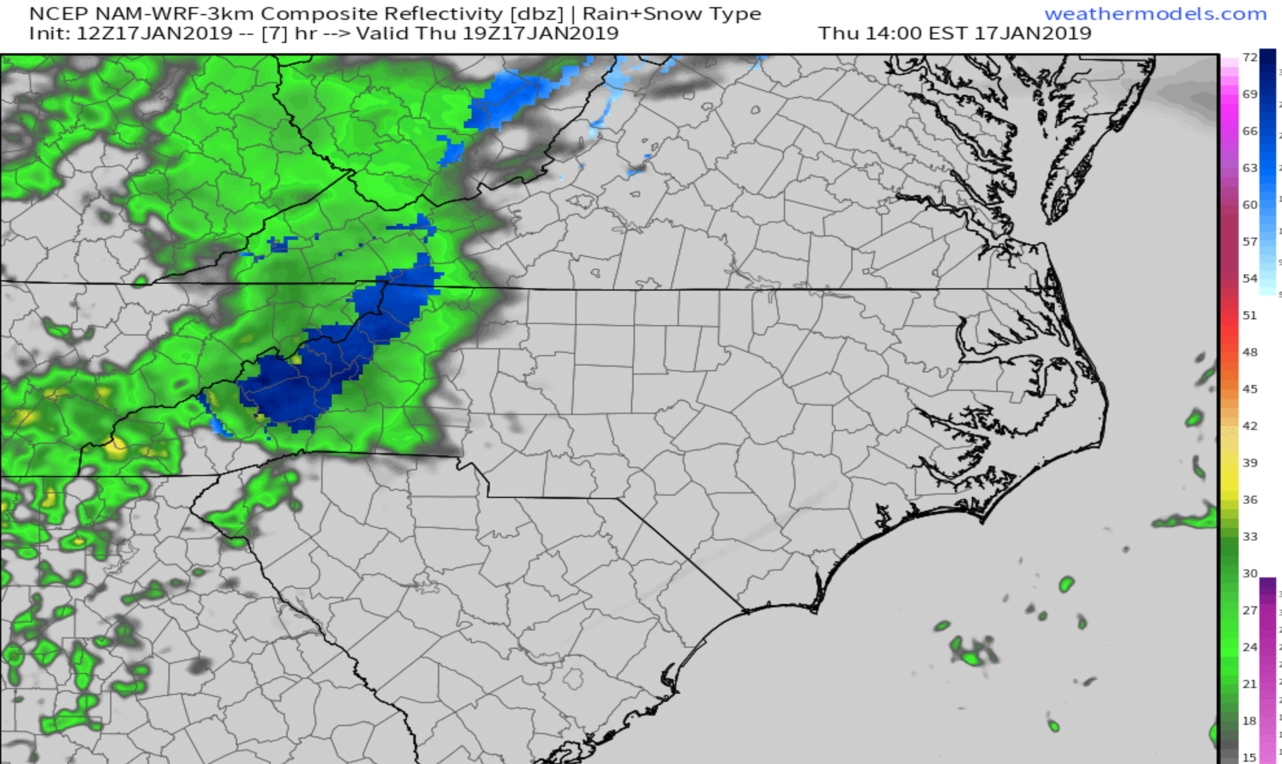
Short Range Models Indicate Rain To Snow Transition Possible This Afternoon Around Asheville

The most recent run of the Nam 3km indicates that a switch from rain to snow will be possible this afternoon as precipitation becomes heavy around WNC. This switchover will not occur everywhere, but some locations that do switch to snow could see a dusting to 1” of accumulation. Below you can see the most recent precipitation depiction map for 2-3pm this afternoon. It shows a heavy band of precipitation (that you can currently see in Eastern Tennessee) moving through WNC and switching to snow for some locations.

12z 3km Nam Precipitation Depiction Courtesy of Weathermodels.com

12z 3km Nam Precipitation Depiction Courtesy of Weathermodels.com

Trust The Tax Pros

It’s time to get your taxes done again this year, so why not let the local pros at C.P. Kruse handle the hassle for you? Call them at (828) 684-7374 or visit their website http://www.kruseaccounting.com

Here is the total snowfall map that the 3km nam produced. I expect precipitation to begin to move in over the next hour or so, and a switch could occur around 2pm-3pm. This map shows a widespread dusting. This indeed is possible, and if heavy snow were to fall for an hour or so, a dusting to 1” would be the result. Be sure to report what you are seeing to the AshevilleWX Weather Community on Facebook!

12z 3km NAM Snowfall Totals Courtesy of Weathermodels.com

12z 3km NAM Snowfall Totals Courtesy of Weathermodels.com

Rain/Some Snow Flurries Move Into WNC Today, Then Arctic Air Expected To End Weekend

A surface front will move through WNC later this afternoon, and that could bring interesting weather to many around the area. Some models suggest that these rain showers could switch to snow in some valleys. Higher elevations will certainly see a switch over, and some locations above 4000’ could pick up a quick couple of inches. Roadways in higher elevations could get slick this evening, but temperatures will rebound tomorrow.. so just be patient if your road is snow covered and you feel unsafe to drive. Below is the current radar (9:00am) and you can see a large swath of moisture in TN making its way towards WNC. A cold wedge is setup across portions of the area, and that could help create mixed precipitation as the heaviest precipitation moves through the area. Its hard for me to pin point exactly which areas will mix, but locations who received ice over the weekend (favored CAD areas) are more likely to see that switch because CAD wedge air is what will produce it.

It’s Tax Season Again

That means its time to contact the local pros at C.P. Kruse Accounting to handle all your tax prep needs! Call them at (828)684-7374 or visit their website http://www.kruseaccounting.com

Both global models (GFS&Euro) show some type of switchover around the Asheville Airport later tonight, but the short range models don’t really see it that clearly. Temps hover in the upper 30’s and upper level temperatures are less supportive. Therefore a blend of the two would be flurries mixing in with rain as the system moves through the area. Here is The GFS snowfall map. You can see that it believes a dusting is possible in Henderson Co. but I am hesitant to believe it is correct because it doesn’t have short range model support.

6z GFS Snowfall Total Courtesy of Weathermodels.com

Compare that with the most recent NAM 3km run (below) snowfall totals, and they are very different. I tend to side with the NAM 3km, but we will see what the runs today show.

6z Nam 3km Snowfall Totals Courtesy of Weathermodels.com

6z Nam 3km Snowfall Totals Courtesy of Weathermodels.com

Please report any snowfall to the AshevilleWX Weather Community on Facebook.

Arctic Air Moves In, Snow Showers Possible Sunday

More rain looks likely Saturday night into Sunday, as an arctic front moves through the area. Rain will begin late Saturday around WNC, and could switch quickly to snow sometime early Sunday morning. The details regarding this front still need to be hammered out, but temperatures Monday morning around WNC could fall into the low teens. Elevations above 3500’ will most certainly see snowfall from this event, in fact a couple of inches of accumulation cannot be ruled out. Below you can see the GFS precipitation depiction, and that northwest flow moisture banking up against the Appalachians.

6z GFS Precipitation Depiction Sunday Morning Courtesy of Weathermodels.com


As that moisture gets strained out, winds will likely carry snow showers into the valleys below. I will do another video update in the AshevilleWX App tonight so make sure you have that downloaded! You can watch active weather on AshevilleWX’s live webcam network.. Those can always be found here:

Grimes Teich Anderson Downtown Asheville Camera

Henco Reprographics Candler/Mt. Pisgah Camera

Olivette Riverside Farm Community Alexander, NC Camera

Haywood County Farm Bureau Insurance Canton/Dutch Cove Camera

Long Range Models Show Pattern Change, Arctic Air For Southeast Late Next Weekend

Some rain/snow showers are possible around WNC this evening and into tomorrow, with higher elevation locations(above 3500’) seeing some form of accumulation. I don’t expect to see totals much over 3” though even in the highest elevations. I have moved my focus towards the pattern change that will occur late next weekend. Long range models are hinting at a Polar Vortex displacement, and that would allow extremely cold air to move into the Southeast beginning next Sunday.


How Cold Are We Talking?

Some models have indicated that low temperatures could push into the negatives digits around WNC, but we are still 8-10 days away from that cold..so a great deal can change. Below you can see the most recent GFS FV3 temperature depiction for Sunday morning. It drops temps into the low teens, with Northwest Flow moisture streaming in off the Great Lakes.

Fv3 GFS Temperature Depiction Next Sunday AM Courtesy of Pivotalweather.com

Beat The Tax Rush

Schedule your appointment today with C.P. Kruse, the best in business in WNC. Call (828)684-7374 or visit their website http://www.kruseaccounting.com. They can handle all of your accounting needs!

Northwest Flow Moisture Streaming In All The Way From Great Lakes Sunday AM. Courtesy of Pivotalweather.com

The storm depicted is interesting because its a strong arctic front that pushes through the area. Some models have indicated that it could move farther south, and that leaves the door open to a more wintery solution in WNC. So what you need to know is that I have my eye on next weekend and a strong(more winter like) pattern change that looks to occur. I will be doing a live in-app update at 5:30pm today so be sure to download the app and tune in. I will also be discussing a shortwave front that will move through WNC Thursday into Friday. This front could bring some snow showers to higher elevations locations, so be sure to join me as I cover the possibilities!


Freezing Rain, Sleet, and Snow All Possible Around WNC This Weekend

A mixed bag of precipitation is likely over the weekend around WNC, and portions of the Piedmont. Cold air will be funneled in ahead of the front, allowing surface temps to dip below freezing as precipitation moves in. It is still uncertain exactly how this system will unfold, but here are my latest thoughts on how the event will unfold! This will be an extend event, and backside snow showers could linger through Monday evening. As heavier precipitation moves into WNC Saturday night, roadways could become slick as snow/sleet/freezing rain falls. Some models show surface temps in the upper 20’s when this heavy precipitation moves in, and that will likely cause travel problems for many. This cold wedge will struggle to reach west of Asheville, and a warm nose could keep those areas less icy. Some models though show the cold wedge all the way into NGA, so uncertainty is the key here. Prepare for an ice storm, and hope it doesn’t come to fruition… I will be live tonight on the AshevilleWX App at 7pm so join me there as I detail out the timing of precipitation, and what p-types are most likely to fall in which areas!

It’s Tax Season

Beat the rush and schedule today with the best accounting firm in Asheville! Call (828)684-7374 or visit http://www.kruseaccounting.com

Ice Threat On The Increase As Weekend Storm Approaches WNC

A warm nose of air will come into play late Saturday and into Sunday as the front moves into to WNC. Depending on how warm this nose is will determine how long WNC sees frozen precipitation. Earlier on in the week models keyed in on the front tongue of precipitation bringing snowfall, but that threat seems have subsided somewhat. There is also a backside component with this storm that could bring snow showers even into Tuesday morning. This will be problematic for higher elevation locations, and we very well could see accumulating snowfall sometime Monday from the backside even around Asheville. So, this morning I preach uncertainty. Prepare for an ice storm around WNC, because freezing rain does look possible. Below is the most recent GFS model run depiction of how much freezing rain could fall. Join me live tonight on the AshevilleWX App at 7pm or on Facebook which will follow shortly!

GFS Freezing Rain Totals Courtesy of Pivotalweather.com

GFS Freezing Rain Totals Courtesy of Pivotalweather.com

Beat The Tax Rush

Contact C.P. Kruse & Co. today to set up your tax appointment. C.P. Kruse are the local professionals to trust when it comes to crunch time during tax season. Call (828) 684-7374 or visit http://www.kruseaccounting.com


Wind Gust Could Top 50mph Tonight Around Asheville

Winds have already picked up around WNC today, and that looks to continue through the evening and early hours of tomorrow morning as a strong low pressure exits the US. Short range models indicate that gusts above 50mph are likely at the Asheville Airport, and even higher wind gusts are expected above 3500’. It would be wise to secure outdoor accessories this afternoon in order to keep them from blowing away! After this front passes, temperatures will plummet, and highs over the next few days will struggle to push out of the 30’s. Some higher elevation locations above 4000’ will experience snow showers late tomorrow night and into Thursday morning. A stray flurry cannot be ruled out in the Asheville area. This all sets the stage for the weekend winter storm. Join me live tonight at 7pm as I go into more detail regarding how this weekends event will unfold.

High Res NAM Wind Gusts Tonight

High Res NAM Wind Gusts Tonight

IMG_6120.png

The local Tax Pros

Looking to have your taxes done by trusted local professionals? Look no further than C.P. Kruse & Co. With a reputation of being trustworthy, C.P. Kruse is the perfect choice to help your business thrive! Call them today (828) 684-7374 or visit their website http://www.kruseaccounting.com

Winter Weather Appears Likely This Weekend For WNC

All major global models indicate that some form of winter weather will be possible around WNC this weekend, and into Monday of next week. There is agreement that a shortwave will move out of the Rockies, and make its way into a broader trough aloft Thursday across the center of the country. As this shortwave interacts with the Southern Jet, overrunning precipitation will fill in ahead of the front along the zone of truncation. Where this zone sets up, and how much moisture is available still remain to be seen. Right now the GFS shows the most precipitation associated with the system. The European models is much drier, and really struggles to advance an meaningful precipitation towards WNC until early Sunday. So, again I preach uncertainty. What we know is that the Northern & Southern Jet stream will likely come together, and this storm could be larger than what models currently show. Tonight I will be doing a Live in-app video around 7pm, and then a Live Facebook video will follow. To tune in on the app just download here! Below is the most recent precipitation depiction from the GFS showing Saturday morning. That initial tongue of precipitation moves in early Saturday morning, and precipitation (per this model) continues through Sunday afternoon. Other models take the low pressure up the spine of the Apps, and that would mean ice for many in WNC. So the main takeaway from this article is that wintry weather is possible around WNC this weekend, and you should pay close attention to the weather over the next few days as we get a better of how the situation will unfold!

6z GFS Precipitation Depiction For Saturday Afternoon Courtesy of Weathermodels.com

The Local Tax Experts

Need your taxes done this year, but tired of the corporate giants? Call the local professionals at C.P. Kruse for the personal tax touch! Beat the rush and set up your appointment today! (828) 684-7374 or visit http://www.kruseaccounting.com

Models Hinting At The Possibility For Snow This Weekend Around WNC

Long range models continue to resolve a possible winter storm that looks to move through WNC next weekend, and that could cause problems for some. There are a multitude of possibilities still on the table regarding how this system will unfold.. but adequate cold air does appear to be embedded before the storm arrives, and could stay entrenched throughout the duration of the event. What that means is that there is a likelihood that this precipitation could fall as snow or ice.


Will It Be Snow, Ice, Or Just Rain?

As I previously stated, and as with most southeast winter storms, a great deal of uncertainty lies ahead as we approach this weekend. The GFS models shows a long duration multiple wave event, whereas the Euro shows minimal precipitation, but somewhat cooler temps. Models will get a better idea as week move through Tuesday and Wednesday, so be sure to download the AshevilleWX App where I will be doing live video updates all week! Below is the snowfall map from the most recent run from the GFS run. This is only one model depiction, and should only be taken with a grain of salt.. but models are hinting at the possibility. Join me tonight at 7:30pm on the AshevilleWX App where I will detail out the most recent model runs!

GFS Snowfall Totals Thru Sunday Courtesy of Weathermodels.com

Need Tax Help?

The Professionals at C.P. Kruse & Co. can take care of all your tax season needs! Cal them at (828) 684-7374 or visit their website http://www.kruseaccounting.com