Morning Storms Still Possible Around WNC Tomorrow, But Pattern Change Looks To Be On The Horizon For Mid Next Week

Storms Likely Tomorrow AM

A strong front that will bring tornados to parts of AL, MS, & TN tonight, will make it way towards WNC tomorrow morning. Its a bit difficult to nail down timing exactly, but my best guess is that the line of storms will move through between 6am-8am. It could be a tad later though for some locations. The main threat in my opinion will be straight line wind damage. A tornado cannot be totally ruled out, but the timing and weakened atmosphere will be very limiting factors. In fact, I expect the storms to somewhat dissipate as they move over WNC. Locations farther SW like Murphy & Andrews, NC stand a much better chance of seeing damaging winds/tornadic development compared to Asheville. Below you can see the most recent NAM 3km, and it has the line falling apart over Asheville around 8-9am tomorrow morning.

18z 3km NAM Radar Depiction At 10am Tuesday Courtesy of Weathermodels.com

I am expecting a half inch or more of rain for most out of this line of storms, but it will be moving very quickly so I believe flash flooding will be minimal. Some power outages could occur due to gusty winds, so please keep that in mind.

Another Front Moves Through Friday

Long range models indicate that another front will move through WNC on Friday, bringing with it the chance for more rain and possibly storms. High elevation snow showers will also be possible as northwest flow moisture streams in on the backside. Temperatures should get down close to freezing again for most locations in WNC, and it will feel winter-like.

Pattern Change Looks Likely Mid Next Week

A winter like pattern has been manifesting itself on the very long range model images, and many times that can lead to very cold temperatures in the Southeast. Some models even show something wintery, but it is still way too far out to speak in those terms. What you need to know is that cold temperatures look to be on the long range horizon, and you should get your big coat ready!

Severe Weather Possible Monday And Tuesday Around WNC

Strong Front Set To Move Through Southeast

An extremely strong low pressure system will move from the South to the Midwest rapidly, and that will bring the potential for severe weather here in the southeast. Tornadic activity will be likely tomorrow evening in parts of TN, AL, & MS… with EF-2+ strength possible. This front will race toward Western North Carolina, and should provide multiple rounds of storms. Below you can see the Severe Prediction Centers graphic for tomorrow severe outbreak.

Luckily for WNC, the two pieces of energy that will move through will both move through in the morning hours.. not allowing for daytime heating to destabilize the atmosphere as much. Below is the SPC’s Tuesday graphic. They have indicated that a Slight severe threat is possible all across portions of NC/SC/GA.

Ward Enterprises Logo  black - No background .png

Build Your Dream Home In WNC

Contact Larry or Hunter Ward (828)691-5000 to discuss building the home of your dreams in WNC!

What To Expect Here In WNC?

Models indicate that two separate waves of energy will move through WNC over the next two days. The first will begin late tonight and persist through rush hour tomorrow morning. Following that, some clearing will occur as a severe outbreak begins across parts of the Deep South. Throughout the day tornados will be possible in AL/MS/TN as the front pushes towards WNC. It will arrive early Tuesday morning, and could very well wake you up. I expect thunder, lightning, high wind gusts, and heavy rain. Some isolated hail can also not be ruled out. Below is the NAM 3km simulated radar around 5am tomorrow morning.

Monday Morning Radar Around 5am Courtesy of Weathermodels.com

After this moves out, some clearing occurs Monday afternoon. Then early Tuesday the second spoke of energy rotates through, and that will be the one with the most punch. Below is another radar depiction, this time of Tuesday morning.

Tuesday Morning Radar Around 11am Courtesy of Weathermodels.com

How Much Rainfall To Expect

Many locations will receive over 1” of rainfall over the next two days, and some slight flash flooding could be possible. Below is the 3km NAM precipitation totals for the next three days, and you can see that many locations along the Blue Ridge Escarpment will see over 3” of rainfall. Some isolated locations could see 5”+ of rainfall, but its hard to pinpoint those locations exactly. Around Asheville I believe 1.5”-2” of rain will be possible with strong storms Tuesday Morning. Check back as these storms approach, I will go live on Facebook if necessary to keep you weather aware!

Total Precipitation Thru Tuesday Courtesy of Weathermodels.com

Snow Shower Likely In Highest Elevations Tonight And Tomorrow AM

Short Range Models Indicate Backside Moisture Present

Elevations above 4500’ this evening could see rain change over to snow showers along the NC/TN border. This backside moisture with strain itself out over the border counties this evening, and a messy night looks to be on tap. I believe that below 4500’ rain is the more likely precipitation type, but I cannot rule out a few flakes mixing in above 3000’. This moisture will mainly be confined to the NC/TN border continues, but some rain may push all the way into Asheville if surface winds gust high enough. I am not expected any snow in the valleys though, temperatures appear to be too warm.

18z 3km NAM P-Type Map courtesy of weathermodels.com

18z 3km NAM P-Type Map courtesy of weathermodels.com

Gusty Winds

Winds will pick up as the evening progresses, and some higher elevation locations could see winds gust over 50mph. Around Asheville, winds could gust over 30mph at times, so please secure any outdoor accessories that you may still have outside. Below you can see the 18z NAM 3km wind gust map, and it shows high wind gust all along the Blue Ridge Escarpment tomorrow morning.

18z 3km NAM Wind Gust Map courtesy of weathermodels.com

18z 3km NAM Wind Gust Map courtesy of weathermodels.com

Ward Enterprises Logo  black - No background .png

Looking To Build In WNC

Contact Larry or Hunter Ward (828)691-5000 to begin discussing building the home of your dreams in WNC.

Will Snow Accumulate In Highest Elevations?

Short range models indicate that locations above 6000’ could very well receive a dusting of snowfall by tomorrow morning. Locations like Clingmans Dome & Roan Mountain in my opinion have the best chance to see a dusting due to their approximation to the NC/TN border. I wouldn’t be surprised to see a slushy inch or two at Clingmans Dome on the webcam tomorrow morning. Below you can see the 3km NAM snowfall accumulation map, and it indicates that some accumulation will be possible. These maps are somewhat inconsistent though, especially at the start and end of winter when warm ground temperatures cause havoc. If you do see snow at your location, send me pictures at Ashevillewx@gmail.com! I will post them!

Rain Set To Move In Later This Afternoon

A strong front will move through WNC beginning this afternoon, and will persist through Friday morning.  Gusty winds, rainfall, and a few claps of thunder are all possible.

Timing

Models indicate that rain will move in later this afternoon between 3-5pm.  These showers could be heavy at times in some locations, and will last through mid morning Friday.  


NAM 3km expected precipitation courtesy of weathermodels.com

NAM 3km expected precipitation courtesy of weathermodels.com

As you can see if the map above, some location a may only see .25” of rainfall from this.  So more of an annoying rainfall then anything else.  


Looking Ahead

Temperatures Saturday morning will fall back into the upper 30’s, and some locations could again experience frost.  Saturday afternoon though temperatures will recover into the upper 50’s to low 60’s.  Similar conditions will be seen around WNC on Sunday.  Following the weekend, another front will move through mid next week and will bring the chance for more storms.  Check back soon for another update and have a great weekend!


Trick-or-Treat Forecast, If You Dare

Not So Frightful Temperatures

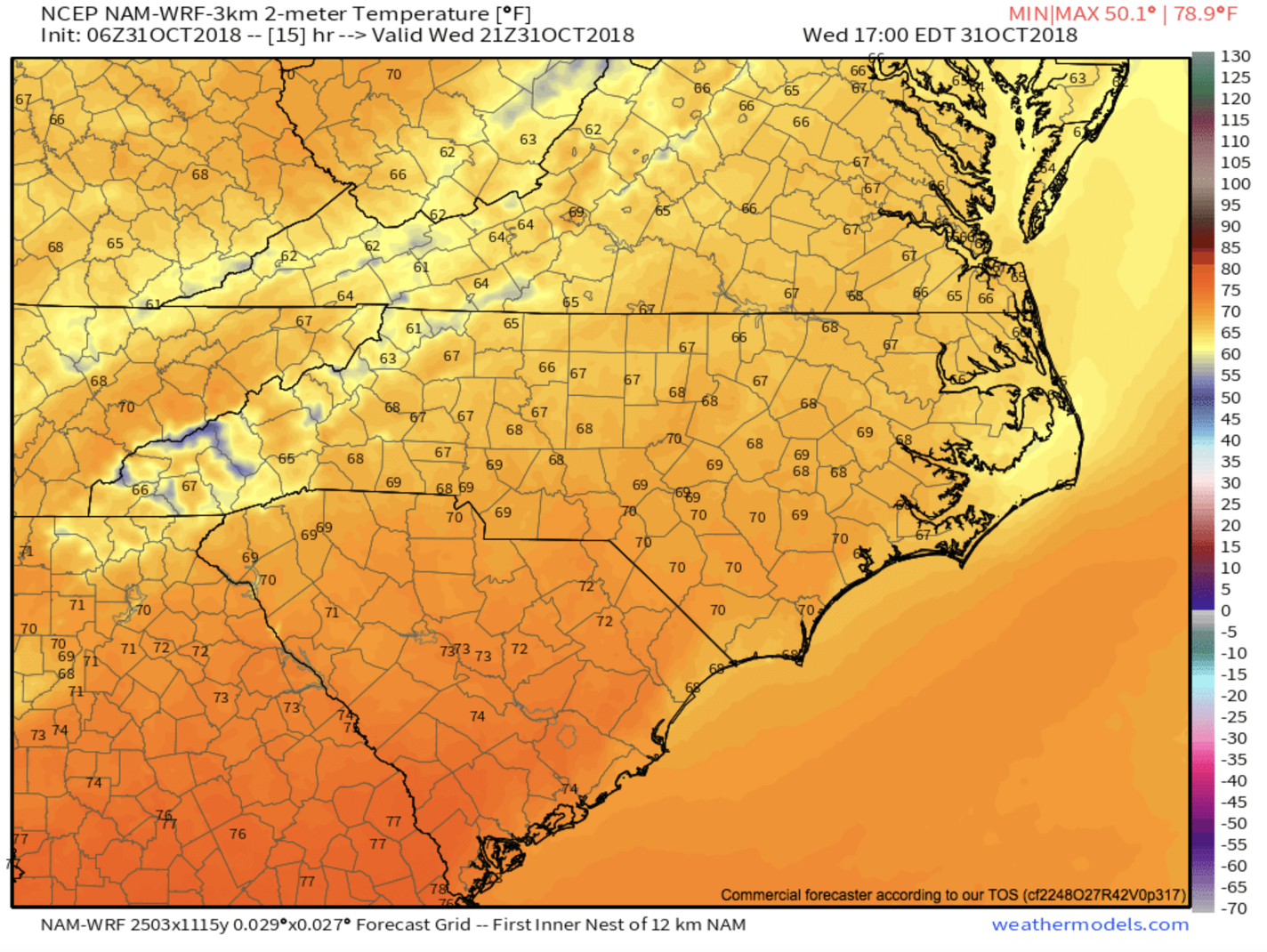
A beautiful Halloween day awaits you today in WNC! Sunshine and mild temperatures are on tap as you head out to your goulish festivities, so have no fear! The real fright though will come with the following storm systems. Over the next week severe weather will be the theme, with strong fronts moving through the area Thursday night into Friday, and then mid next week. These fronts will bring some tornadic activity to parts of the Southeast, but I believe that the threat will be minimal here in WNC.

Halloween Temperatures..  Map courtesy of Weathermodels.com.

Halloween Temperatures.. Map courtesy of Weathermodels.com.

Below you can see the front moving in late Thursday night. This front will bring heavy rainfall to the area, and some locations could see 1” or more fall. Lightning, thunder, heavy rain, gusty winds over 45mph, and some flash flooding cannot be ruled out. Check back with Ashevillewx tomorrow, we will have a full breakdown of what to expect!

Front Moving In Thursday Evening..  Map courtesy of Weathermodels.com

Front Moving In Thursday Evening.. Map courtesy of Weathermodels.com

Scattered Showers This Evening, Severe Storms By The End Of The Week Around WNC

Models Show Scattered Showers This Evening

Lokking at the most recent NAM 3km model, it indicates that a band of showers that has developed across Kentucky will move through WNC this evening. This showers could be heavy for a short duration.. but I am not expecting more than .25” of rainfall accumulation in most locations.

NAM3kmSundayShowers.png


These showers will be short-lived, and cooler temperatures will return as this front passes. Lows tomorrow morning around WNC look to be in the upper 30’s for most. Clearing will follow, and that will be the theme until a stronger storm system moves through the area Thursday into Friday.

Ward Enterprises Logo  black - No background .png

Looking To Build Your Dream Home In WNC?

Contact Larry or Hunter Ward (828)691-5000 to discuss building your dream home in WNC!

Trick-or-Treating Weather Looks Great!

Models show temperature in the mid 50’s on Halloween night with little to no chance for rain! So wear a jacket & enjoy!

Storms Will Move Through WNC Late Week

Models continue to indicate that a very strong system will form across the Central part of the US, and move towards WNC. Timing for these storms looks to be Thursday Afternoon into Friday.. but that can change as we approach the event.

Sunday 12z GFS Model Depiction

Lightning, gusty winds, thunder, and rainfall of around 1” can be expected from this front. Temperatures will fall back close to freezing after the front passes, and I can’t rule out the chance for high elevation snow showers. Check back soon for another update, and have a great Sunday!

Heavy Rain, High Elevation Snow Still Possible Tomorrow Morning Around WNC

Heavy Rain, High Elevation Snow Still Possible Tomorrow Morning Around WNC

A stout low pressure system, formally known as Hurricane Willa that hit the Mexico Coast, will move through WNC tomorrow. As it reaches the Atlantic Coast, it will likely strengthen and create some problems for the East Coast. Here in WNC, I am expecting 1”+ of rainfall for most everyone, with some locations seeing as much as 3” of rain before Friday evening. Some slight flash flooding could occur with this system since the rain will come fairly quickly and could come down hard for a couple of hours. Below you can see the most recent NAM 3km total precipitation map. Locations north of Asheville will likely see less rainfall compared to Asheville.. but a general 1” or so can be expected.

Snow Showers Possible Friday Above 4000' Around WNC

Snow Showers Possible Friday Above 4000' Around WNC

A strong Gulf low will develop off of the remnants of Hurricane Willa that is currently affecting Mexico, and that could make for interesting weather to end the week around WNC. Rainfall will begin to stream in early Friday morning, and for some locations.. that could begin as snow. The highest elevations stand the best chance of seeing snowfall (especially above 4000’), but I can’t rule out places like Burnsville and Spruce Pine beginning with a few flakes as well. These cold upper level temperatures will quickly retreat though, and most everyone below 5000’ will switch to rain. Surface temperatures will be warm, so no accumulation is really expected, except in the highest elevations.

Mid To Upper 30's Possible Thursday Morning Around WNC

Mid To Upper 30's Possible Thursday Morning Around WNC

It appears as though we will skip right into near freezing temperatures around WNC, after a relentless heatwave pushed us through the end of September and into October. Models indicate that higher elevations could see there first freezing temperatures of the season (above 3500’), and elevations in the valleys below could dip into the 30’s for the first time in several months. This will likely kill off weak vegetation that thrived in the previous heatwave. It would be wise to move plants indoors as well Wednesday evening. Below is the most recent(18z) run of the NAM and you can see that it shows 37 possible for the Asheville Airport on Thursday morning. The following image is the 12z European depiction of possible temperatures Thursday morning, and despite a few variances, the models seem to be in good agreement that temperatures below 40 degrees are very possible.