


Volatile Winter Ahead With Average Precipitation & Large Temperature Swings In Store For WNC
Each year I try and put together a general idea of how I think winter could play out around WNC based off of history, and the use of long range forecast methods. This includes the observation of the state of Sea Surface Temperatures (SST), the QBO (stratospheric winds), Solar Max/Mins, ENSO (El Nino/La Nina), and other various atmospheric anomalies that play into the complicated equation of winter weather in the Southeast. These methods are not exact, and many variables must be accounted for.. therefore accuracy from time to time is limited, especially here in the mountains of WNC. So without further ado, below is my 2019-2020 Winter Forecast for NC.
AshevilleWX 2019-2020 Winter Forecast

Come to where Mother Nature waved her magic wand and created one of the most natural of all wonders, Natural Hot Mineral Waters. Heated deep within the earth, these crystal clear carbonated waters are are world famous for their mineral content and legendary healing powers. We pipe these waters to modern outdoor jetted hot tubs that we rent privately by the hour. In addition to our World Famous Natural Hot Mineral baths the day spa offers massage, body treatments, and skin care options. Hot Springs Resort also offers accommodations and camping options. Please visit http://www.nchotsprings.com for more information.
Large Temperature Swings Expected This Winter
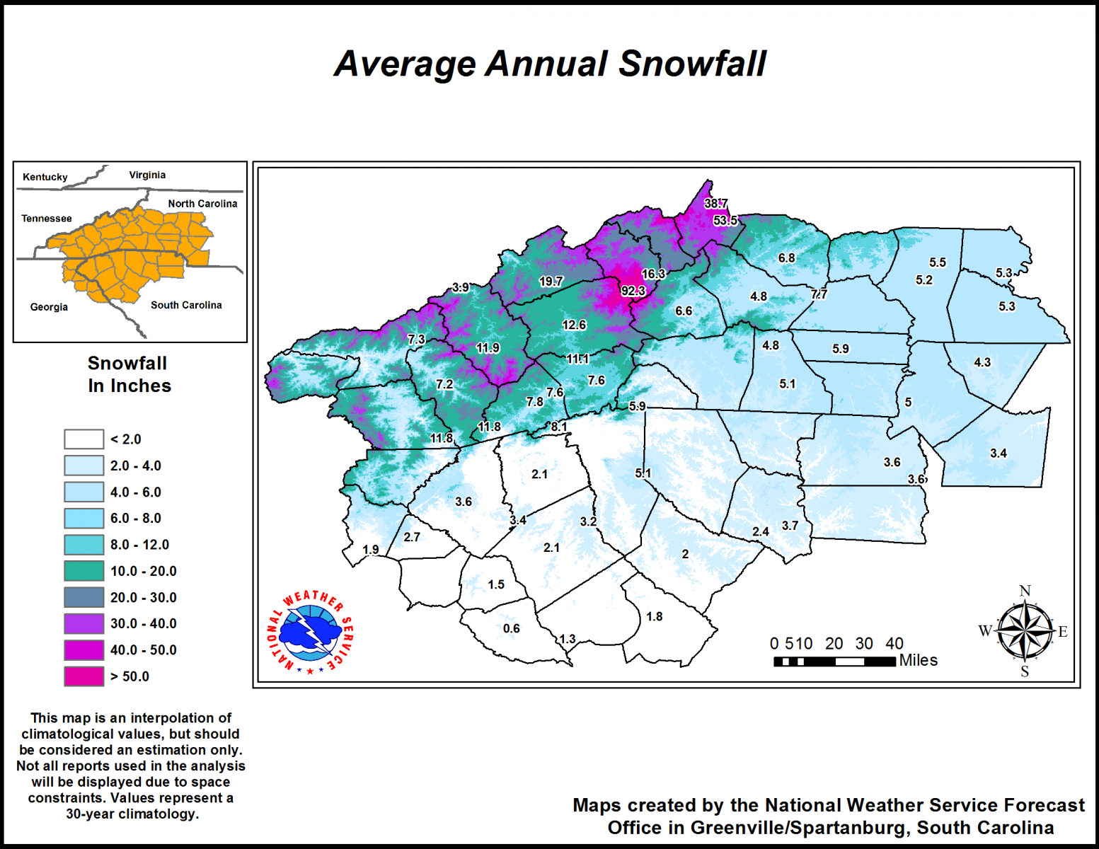
For Western North Carolina this winter, I am expecting average to above average snowfall in locations above 3500’, and slightly below average to average snowfall for locations below 3500’. I am basing this off of the belief that Northwest Flow snow will be more often this year compared to some other previous years, and that we will receive one or two moderate to large snowfall that will satisfy averages around the area. Below is the average annual snowfall for WNC per the NWS in GSP. If you extrapolate my percentages, you will determine that I expect around 10”-11” of snow total for Asheville this year. That would not be a blockbuster winter, but would fall in line with the average over the past 30 years.
Courtesy of GSP NWS
Here is the average seasonal snowfall for the entire state of North Carolina per the National Weather Service. As I stated earlier, I expect one or two big storm for the Southeast, and that will likely satisfy or come close to satisfying many averages. It doesn’t take much for some locations! With a near natural ENSO (El Nino/LaNina Index), we will likely enter into what is considered a Modoki El Nino, which is rare. Only a few years previously have been Modoki El Nino years so we have very little to compare to.
Modoki El Nino
So what exactly is a Modoki El Nino or even El Nino? When long range forecasting, meteorologist will observe the sea surface temperatures anomalies (SST) in a particular region of the Pacific Ocean know as Nino 3.4 region. Depending on where the water is cooling and warming at, plays a huge part in where systems develop in winter, as well as the direction they move. The United States weather moves in from the Pacific Ocean, so where storms develop, and which path they take towards the US matters greatly. Below is a graph showing what a strong El Nino would look like in the Nino 3.4 region taken from the year 2015.

Call the team that keeps my truck clean at A&R Specialist! David, Matt & Harley run A&R Specialist at 621 Brevard Rd. and they are the guys to trust with your vehicle cleaning & detailing. Whether you need a deep wax every once in a while or a quality clean and detail, you can feel safe putting your car in the hands of A&R Specialist! Call (828) 708-3718 to set up your appointment today. https://www.facebook.com/ARpressurewashing4/
La Nina on the other hand is a cooling of the 3.4 Nino region. You can see what that looks like on the graph below from the winter of 2010-2011.

Currently the ENSO region is showing a near natural signal, and many experts believe that it will either stay neutral or move slightly positive through the winter. A modoki El Nino is a near netural El Nino where a large basis of the warm water is positioned in the eastern portion of the Nino 3.4 region. You can see below the current sea surface temps and in the Nino 3.4 region there is only slight warming. At the end though, notice how it is extending to the East. That is a sign that a Modoki El Nino could be on the horizon.
Source: CPC
Modoki El Nino History In WNC
Years of Occurrence:
Winter (Nov-Mar)1991-1992 Asheville Snowfall: 1.5” Asheville Total Precipitation: 18.46”
Winter (Nov-Mar)1994-1995 Asheville Snowfall: 3.4” Asheville Total Precipitation: 18.56”
Winter (Nov-Mar)2002-2003 Asheville Snowfall: 17.9” Asheville Total Precipitation: 20.63”
Winter (Nov-Mar)2004-2005 Asheville Snowfall: 6.6” Asheville Total Precipitation: 16.35”
Winter (Nov-Mar)2009-2010 Asheville Snowfall: 39.2” Asheville Total Precipitation: 28.95”
These are the only years that an east based natural Nino (Modoki El Nino) has been present. As you can see, it’s a relatively new phenomenon. With that east based warmth, comes ample amounts of moisture that move into the Southeast. So, based off the numbers provided, one can assume that if the temperatures in Nino Region 3.4 stay consistent.. 15”+ of precipitation around WNC will be likely this winter. But will the cold air be in place for snow? That is the question, and we will need to look more at the winters of 2002-2003 & 2009-2010. I will observe the winter of 1991-1992 more closely because we were also in a drought at this point in time during 1991. With 1.27” in September of 1991, & only .19” of rain in October of 1991, WNC was in a deeper drought compared to where we currently sit.. but there are comparisons to be made.
Temperature Data Leading Into Modoki Years For WNC
Average September Temperature For Asheville:
1991: 67.2 degrees
1994: 64.6 degrees
2002: 68.8 degrees
2004: 66.4 degrees
2009: 66.9 degrees
2019: 71.2 degrees
So this tells us that we are leading into a neutral east base El Nino as we come off of our warmest September of all comparison dates. I think that trend continues too, and that a several warm shots will be possible this winter. That doesn’t mean that there will not be cold, but as I stated earlier, I believe large temperature swings will be likely. There is some long range model data to also support this warm idea. Below you can see the European Model monthly temperature anomalies, and each period shows above average temperatures for the Southeast.
NOV/DEC/JAN Courtesy of Weathermodels.com

Contact my local trusted roofing source Matt at RedWolf Contracting Services to take care of all of your roof replacements. From shingles, to metal roofing, and even commercial rubber membrane, Matt has the resources and solutions to take care of your job in a professional and cost effective manner. Call (828) 772-9778 or visit nc-roofers.com to set up your free roof inspection.
DEC/JAN/FEB Courtesy of Weathermodels.com
JAN/FEB/MAR Courtesy of Weathermodels.com
Will It Actually Be As Warm As The Models Show?
A word of caution with the Euro monthly charts, they are great guidance.. but on average last winter they were only right about 20% of the time. That being said, there does appear to be an increasing likelihood that this winter will be above average temperature-wise. So, a smart/easy bet for a winter forecast would be to go with warm and wet… but there is a wildcard this year.
Solar Minimum=Wildcard
We are progressing deeper into a solar minimum, which mean that solar flare activity is trending down. With less sun spots (none in the last 200+ days) this is the least active the sun has been since 2009. Remember the winter of 2009-2010? Almost 40” of snow fell that year at the Asheville Airport. Here’s an excerpt from Whats Up With That regarding how low solar activity correlates to shots of cold.
Low solar activity has been well correlated with an atmospheric phenomenon known as “high-latitude blocking” and this could play an important role in the upcoming winter season; especially, across the eastern US. In addition, one of the natural impacts of decreasing solar activity is the weakening of the ambient solar wind and its magnetic field which, in turn, allows more cosmic rays to penetrate the solar system. The intensification of cosmic rays can have important consequences on such things as Earth’s cloud cover and climate, the safety of air travelers, and as a possible trigger mechanism for lightning.
From Whats Up With That
High-latitude blocking is the key to getting cold air down to the Southeast. When you hear me talk about indices like the NAO & the AO, these are all measures of the degree of high latitude blocking in place. The blocking effectively creates a wall that deflects cold air from the arctic, down into the United States. How strong this blocking is, and where exactly it comes from, will determine how cold it gets in the Southeast.. and across the rest of the East Coast.
So we are entering a period of solar minimum that could rival any other period in the last 100 years. Does that mean record cold is possible? Maybe, but it really just tells me that this will be a unique winter, with several variable that will need to be properly accounted for.
QBO (Quasi-Binary Oscillation)
The last bit of information I will discuss before my conclusion is the QBO. This is a daily observation of stratospheric winds along the equatorial area. Detected over 50 years ago, these winds are measure by radio signal at various points in the atmosphere. By tabulating this data over the past 50 years in an increasingly large area, we have been able to tie certain atmospherical outcomes to either a positive or negative QBO. What you need to know here is that a negative QBO is known to correlate with high-latitude blocking. As you learned a few minutes ago, high latitude blocking sends cold air down into the United States. If a negative QBO stays persistent as projected by many, then cold shots this year will be likely.
Conclusion
So I know that I have detailed out a lot of information, but what you really need to know is that I believe that an East based Modoki El Nino will provide ample moisture that moves through the Southeast. At some point in time this winter, the high-latitude blocking will get in place, and put enough cold air into WNC and other portions of NC as moisture moves in from the Southeast, and in turn snow will fall. How often that happens is of course an unknown, but there are signs that indicate that the players will be on the field for a snowstorm this winter. We will see exactly how the Solar Minimum plays in because many experts are calling for a very warm winter. If we end up cold, or below normal temperature-wise, the Solar Minimum will have to be taken seriously. So again, I expect 1-2 large storms that will put many locations across NC at or close to their average yearly snowfall. Temperature swings will be frequent, and record daily highs/ lows both cannot be ruled out. It will be volatile. With this volatility I believe will come the possibility of frequent Northwest Flow Snow for the higher elevations of WNC. This will push those areas above their normal yearly averages. Asheville should expect around average snowfall, and as you progress east, the chances for a significant snow decreases. This is my best guess, and is only a forecast. These forecast can easily be busted or made by 1 storm, so please stay tuned for my daily forecast to keep yourself up to date on the approaching weather!
-Meteorologist Hunter Ward


