Severe Weather Likely Today For WNC, Isolate Hail Cannot Be Ruled Out

Severe weather will be possible today across WNC as the Severe Prediction Center has issued a Slight risk for severe weather across the area. Below you can see the most recent imagery coming out of Norman, OK where the SPC is located.

NC_swody1.png
Contact my local trusted roofing source Matt at RedWolf Contracting Services to take care of all of your roof replacements. From shingles, to metal roofing, and even commercial rubber membrane, Matt has the resources and solutions to take care of yo…

Contact my local trusted roofing source Matt at RedWolf Contracting Services to take care of all of your roof replacements. From shingles, to metal roofing, and even commercial rubber membrane, Matt has the resources and solutions to take care of your job in a professional and cost effective manner. Call (828) 772-9778 or visit nc-roofers.com to set up your free roof inspection.

Timing

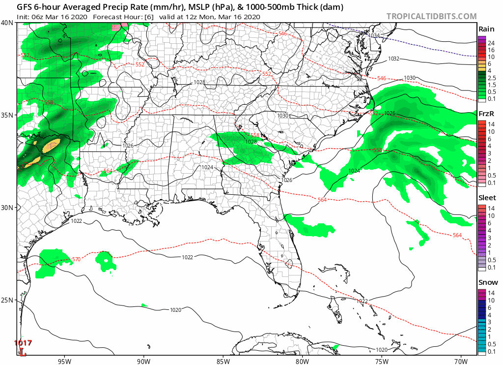
After overcast skies clear around WNC this afternoon, fuel will begin to build in the atmosphere as the sun comes out. Below you can see the most recent NAM 3km precipitation depiction and timing. The disturbance appears to move through later tonight around 8-9 pm for WNC. This will be a perfect time to check the AshevilleWX Webcams!

NAM 3km Courtesy of Weathermodels.com

For the finest landscaping in Western North Carolina, contact Sam Byrnside of L & S Landscape for a free estimate. From planting to mowing, mulching and all landscaping necessities in between contact Sam & his team! L & S also does salti…

For the finest landscaping in Western North Carolina, contact Sam Byrnside of L & S Landscape for a free estimate. From planting to mowing, mulching and all landscaping necessities in between contact Sam & his team! L & S also does salting of roads & driveways during the winter as well as tow pull outs if you get stuck in bad weather! Just give Sam a call (828)329-6020 to schedule your appointment today! Visit Site

So, late this evening you should expect strong storms to push through WNC. There will be the chance for strong winds, hail, and even an isolated tornado. Below you can see the hail risks that the SPC has released for WNC.

A 15% chance of hail within 40 miles of your location in WNC has been issued. This hail could damage early vegetation, and could be dime+ size. Steep lapse rates above your head will play huge into this and we will likely see somewhere this evening see a severe warned storm.

Come to where Mother Nature waved her magic wand and created one of the most natural of all wonders, Natural Hot Mineral Waters. Heated deep within the earth, these crystal clear carbonated waters are are world famous for their mineral content and l…

Come to where Mother Nature waved her magic wand and created one of the most natural of all wonders, Natural Hot Mineral Waters. Heated deep within the earth, these crystal clear carbonated waters are are world famous for their mineral content and legendary healing powers. We pipe these waters to modern outdoor jetted hot tubs that we rent privately by the hour. In addition to our World Famous Natural Hot Mineral baths the day spa offers massage, body treatments, and skin care options. Hot Springs Resort also offers accommodations and camping options. Please visit http://www.nchotsprings.com for more information.

How Much Rain Will Fall?

It will vary depending on your location, but according to short range models, it appears that locations SW of Asheville, especially along the Blue Ridge Escarpment stand the best chance to see over .5” of rainfall from this. So, I am not projecting a washout, but some locations could see some isolated flash flooding as heavy rain/storms push through. Below you can see the most recent Nam 3km precipitation totals.

Nam 3km Precipitation Totals Courtesy of Weathermodels.com

Call the team that keeps my truck clean at A&R Specialist! David, Matt & Harley run A&R Specialist at 621 Brevard Rd. and they are the guys to trust with your vehicle cleaning & detailing. Whether you need a deep wax every once in a …

Call the team that keeps my truck clean at A&R Specialist! David, Matt & Harley run A&R Specialist at 621 Brevard Rd. and they are the guys to trust with your vehicle cleaning & detailing. Whether you need a deep wax every once in a while or a quality clean and detail, you can feel safe putting your car in the hands of A&R Specialist! Call (828) 708-3718 to set up your appointment today. https://www.facebook.com/ARpressurewashing4/

Watch Storms Move In On The AshevilleWX Live Cams

Severe Storms With Flash Flooding Possible Sunday & Into Monday Around WNC

A very powerful low pressure will travel across the interior of the Untied States this weekend, and that will bring the threat for severe weather all across the Southeast. For Western North Carolina, I am somewhat concerned about the threat for flash flooding. The GFS is now showing a similar solution to the European model, which has depicted ample amounts of precipitation moving into WNC on Sunday afternoon & into Monday for several days. Short range model data will certainly be needed to determine the degree of threat with this system regarding severe weather in WNC, but what does appear possible is flash flooding. Below you can see the most recent projected rainfall totals through early Monday around WNC.

GFS Rainfall Totals Thru Early Monday AM Courtesy of Weathermodels.com

For the finest landscaping in Western North Carolina, contact Sam Byrnside of L & S Landscape for a free estimate. From planting to mowing, mulching and all landscaping necessities in between contact Sam & his team! L & S also does salti…

For the finest landscaping in Western North Carolina, contact Sam Byrnside of L & S Landscape for a free estimate. From planting to mowing, mulching and all landscaping necessities in between contact Sam & his team! L & S also does salting of roads & driveways during the winter as well as tow pull outs if you get stuck in bad weather! Just give Sam a call (828)329-6020 to schedule your appointment today! Visit Site

Will There Be Severe Weather In WNC?

The chances appear to be increasing for a strong line of storms to slam into WNC sometime late in the day on Sunday. As I detailed out in my last live update, we are receiving limited weather data right now due to very little plane activity across the US… so I will need a bit more time to nail this forecast down. There will be several key factors to focus on regarding severe weather across WNC on Sunday, but most importantly the sun will need to shine at some point to ripen the atmosphere. Some models do not show that happening with a stout wedge of clouds that builds in all throughout the morning over WNC on Easter Sunday. You can see that wedge here on the GFS precipitation depiction below.

GFS Precipitation Depiction Sunday Afternoon Courtesy of Tropicaltidbits.com

Come to where Mother Nature waved her magic wand and created one of the most natural of all wonders, Natural Hot Mineral Waters. Heated deep within the earth, these crystal clear carbonated waters are are world famous for their mineral content and l…

Come to where Mother Nature waved her magic wand and created one of the most natural of all wonders, Natural Hot Mineral Waters. Heated deep within the earth, these crystal clear carbonated waters are are world famous for their mineral content and legendary healing powers. We pipe these waters to modern outdoor jetted hot tubs that we rent privately by the hour. In addition to our World Famous Natural Hot Mineral baths the day spa offers massage, body treatments, and skin care options. Hot Springs Resort also offers accommodations and camping options. Please visit http://www.nchotsprings.com for more information.

This wedge that is present on several models will likely inhibit an extreme atmosphere from developing over WNC. With rainfall pushing out ahead of the main front, that will also dampen the atmosphere, so several factors at the moment appear to be limiting for WNC.

Deep South Tornado Outbreak Possible Sunday

Models continue to have a very moist warm sector developing out ahead of a very strong front across parts of MS, AL, LA, & AR on Sunday afternoon. With the Gulf being wide open, the kinematics appear to be lining up for a high end severe event. Currently the Severe Prediction Center has issued a moderate risk with a 45% hatched area for severe weather over portions of MS, AL, LA, & AR.

Looking at the dynamics of this system, and the idea of long track tornados comes to mind. In the past, we have had systems like this ejected across the midwest very quickly but it quite rare. If you remember back to April 27th, 2011 a similar low moved in a fashion like what is being modeled, and a very deadly tornado outbreak took place across the Southeast. With that in mind, many are taking the dynamics that are being presented by models very seriously.

The trusted local accounting firm for WNC, let the team of Adrianne, Caroyl, & Naomi take care of all of your tax needs. Whether you need payroll/business accounting help or assistance filing your personal taxes, these ladies are the experts to …

The trusted local accounting firm for WNC, let the team of Adrianne, Caroyl, & Naomi take care of all of your tax needs. Whether you need payroll/business accounting help or assistance filing your personal taxes, these ladies are the experts to put your trust with. Give them a call (828) 684-7374 or visit their website http://www.kruseaccounting.com to set up your appointment today!

Overnight European Runs Cut Precipitation Totals

The most consistent model over the past 4 days has now began to drop precipitation totals from this event around WNC. Yesterday the European model was showing an excessive rainfall event with over 2” of rainfall inundating all of WNC, but now these totals have been tempered and the most recent run of the Euro shows only around 1.5” of rain falling across WNC through Monday morning. This is a trend to watch, and with so much difference among global model solutions, short range models will certainly be needed to hatch out further details.

Call the team that keeps my truck clean at A&R Specialist! David, Matt & Harley run A&R Specialist at 621 Brevard Rd. and they are the guys to trust with your vehicle cleaning & detailing. Whether you need a deep wax every once in a …

Call the team that keeps my truck clean at A&R Specialist! David, Matt & Harley run A&R Specialist at 621 Brevard Rd. and they are the guys to trust with your vehicle cleaning & detailing. Whether you need a deep wax every once in a while or a quality clean and detail, you can feel safe putting your car in the hands of A&R Specialist! Call (828) 708-3718 to set up your appointment today. https://www.facebook.com/ARpressurewashing4/

More Cold On The Way Next Week

Unfortunately for WNC gardeners, there is another cold shot on the way next week.. so you should delay planting out your tender veggies at least another week. Below you can see the most recent temperature spread from the European model, and it suggests temperatures in the 20’s could even be possible next Thursday morning.

Euro Courtesy of Weathermodels.com

Contact my local trusted roofing source Matt at RedWolf Contracting Services to take care of all of your roof replacements. From shingles, to metal roofing, and even commercial rubber membrane, Matt has the resources and solutions to take care of yo…

Contact my local trusted roofing source Matt at RedWolf Contracting Services to take care of all of your roof replacements. From shingles, to metal roofing, and even commercial rubber membrane, Matt has the resources and solutions to take care of your job in a professional and cost effective manner. Call (828) 772-9778 or visit nc-roofers.com to set up your free roof inspection.

Plan To Cover Sensitive Vegetation Saturday AM & Thursday AM

If possible, it would be wise to plan to cover sensitive vegetation on Saturday morning and then again next week on Thursday morning. Temperatures tomorrow morning will dip to the mid 30’s as seen below on the NAM 3km.

Nam 3km Temperature Spread For Saturday AM

The outlook is rather cold over the next 10 days so putting out plants like tomatoes and squash should be ruled out. Check out Trellis Talk to find out what to plant next! I will be posting a live update soon later tonight or tomorrow morning regarding this threat so be sure to check back for that!

Strengthening Low Pressure To Bring Backside Snow Showers To Some In WNC Above 4000'

A low pressure is currently bringing rainfall to many around WNC, and even a few snow flurries for elevations above 4000’. As the evening progresses, this low pressure will move off of the coast of NC/VA and really strengthen. When this low begins to bomb out, backside moisture will strain out along the NC/TN border and snow showers will pick up for those high elevation locations. A dusting to 1” could even be possible for some, but I am not very optimistic on impactful accumulation. Below you can see how the NAM 3km progresses the moisture.

Come to where Mother Nature waved her magic wand and created one of the most natural of all wonders, Natural Hot Mineral Waters. Heated deep within the earth, these crystal clear carbonated waters are are world famous for their mineral content and l…

Come to where Mother Nature waved her magic wand and created one of the most natural of all wonders, Natural Hot Mineral Waters. Heated deep within the earth, these crystal clear carbonated waters are are world famous for their mineral content and legendary healing powers. We pipe these waters to modern outdoor jetted hot tubs that we rent privately by the hour. In addition to our World Famous Natural Hot Mineral baths the day spa offers massage, body treatments, and skin care options. Hot Springs Resort also offers accommodations and camping options. Please visit http://www.nchotsprings.com for more information.

Nam 3km Courtesy of Weathermodels.com

The trusted local accounting firm for WNC, let the team of Adrianne, Caroyl, & Naomi take care of all of your tax needs. Whether you need payroll/business accounting help or assistance filing your personal taxes, these ladies are the experts to …

The trusted local accounting firm for WNC, let the team of Adrianne, Caroyl, & Naomi take care of all of your tax needs. Whether you need payroll/business accounting help or assistance filing your personal taxes, these ladies are the experts to put your trust with. Give them a call (828) 684-7374 or visit their website http://www.kruseaccounting.com to set up your appointment today!

Where Will Accumulation Be Possible?

Mainly above 4000’, and with that we are speaking of a general dusting to 1” due to warm ground temperatures. Below you can see the most recent NAM 3km snowfall projections, and it has locations like Boone even seeing accumulation, but I think that could be a bit overdone. I do however believe that Boone should see snow showers tonight as backside moisture moves through.

NAM 3km Snowfall Map Courtesy of Weathermodels.com

Call the team that keeps my truck clean at A&R Specialist! David, Matt & Harley run A&R Specialist at 621 Brevard Rd. and they are the guys to trust with your vehicle cleaning & detailing. Whether you need a deep wax every once in a …

Call the team that keeps my truck clean at A&R Specialist! David, Matt & Harley run A&R Specialist at 621 Brevard Rd. and they are the guys to trust with your vehicle cleaning & detailing. Whether you need a deep wax every once in a while or a quality clean and detail, you can feel safe putting your car in the hands of A&R Specialist! Call (828) 708-3718 to set up your appointment today. https://www.facebook.com/ARpressurewashing4/

Will Asheville See Snow Showers?

I am not particularly optimistic about Asheville seeing these snow showers because temps are only expected to dip into the upper 30’s and flakes will struggle to make it to the surface without full melt occurring. Winds will pick up though late tonight and that will be the story into tomorrow for most. Below you can see the peak wind gust projected by the NAM 3km for early tomorrow morning. 20-30 mph gusts are possible.

NAM 3km Winds Courtesy of Weathermodels.com

Contact my local trusted roofing source Matt at RedWolf Contracting Services to take care of all of your roof replacements. From shingles, to metal roofing, and even commercial rubber membrane, Matt has the resources and solutions to take care of yo…

Contact my local trusted roofing source Matt at RedWolf Contracting Services to take care of all of your roof replacements. From shingles, to metal roofing, and even commercial rubber membrane, Matt has the resources and solutions to take care of your job in a professional and cost effective manner. Call (828) 772-9778 or visit nc-roofers.com to set up your free roof inspection.

Temps In the 30’s Likely Wednesday & Thursday AM

Temperatures behind the front will drop into the upper 30’s for most of WNC, and even into the 20’s for higher elevation locations above 3500’. Below you can see the Nam 3km temps for early Wednesday morning.

2m Temps Wednesday AM Courtesy of Weathermodels.com

For the finest landscaping in Western North Carolina, contact Sam Byrnside of L & S Landscape for a free estimate. From planting to mowing, mulching and all landscaping necessities in between contact Sam & his team! L & S also does salti…

For the finest landscaping in Western North Carolina, contact Sam Byrnside of L & S Landscape for a free estimate. From planting to mowing, mulching and all landscaping necessities in between contact Sam & his team! L & S also does salting of roads & driveways during the winter as well as tow pull outs if you get stuck in bad weather! Just give Sam a call (828)329-6020 to schedule your appointment today! Visit Site

Nice Weekend On Tap For WNC

A wonderful weekend appears to be in store for WNC with high temps in the 70’s likely both days. Below you can see the spread of temperatures over the next several days from the European Ensemble. Notice how we will drop into the 40’s though each night so hold off on setting out those tomatos!

EPS Courtesy of Weathermodels.com

Another Round Of Rainfall On The Way For WNC Tuesday, Then Warmth Returns 80's Possible Fri & Sat

Rain will clear this evening around WNC before another strong frontal passage occurs tomorrow. This front could brings a few rumbles of thunder to the area, and another half inch to an inch of rainfall for most in WNC. Below you can see the most recent NAM 3km precipitation totals for the next 60 hours. Notice how many locations in SW WNC benefit from that predominantly westerly flow of moisture. Those locations like Andrews, and Franklin will likely see higher totals compared to the Asheville area.

Nam 3km Precipitation Totals Courtesy of Weathermodels.com

Call the team that keeps my truck clean at A&R Specialist! David, Matt & Harley run A&R Specialist at 621 Brevard Rd. and they are the guys to trust with your vehicle cleaning & detailing. Whether you need a deep wax every once in a …

Call the team that keeps my truck clean at A&R Specialist! David, Matt & Harley run A&R Specialist at 621 Brevard Rd. and they are the guys to trust with your vehicle cleaning & detailing. Whether you need a deep wax every once in a while or a quality clean and detail, you can feel safe putting your car in the hands of A&R Specialist! Call (828) 708-3718 to set up your appointment today. https://www.facebook.com/ARpressurewashing4/

When Will Tuesday’s Rain Move In

A couple of rounds of rainfall appear to be possible moving through the day Tuesday and then Tuesday night, but there is some variability as to when each wave will move through. Below you can see the depiction of the NAM 3km and what it shows regarding the progression of the moisture tomorrow and into the early morning of Wednesday.

NAM 3km Courtesy of Tropicaltidbits.com

NAM 3km Courtesy of Tropicaltidbits.com

Contact my local trusted roofing source Matt at RedWolf Contracting Services to take care of all of your roof replacements. From shingles, to metal roofing, and even commercial rubber membrane, Matt has the resources and solutions to take care of yo…

Contact my local trusted roofing source Matt at RedWolf Contracting Services to take care of all of your roof replacements. From shingles, to metal roofing, and even commercial rubber membrane, Matt has the resources and solutions to take care of your job in a professional and cost effective manner. Call (828) 772-9778 or visit nc-roofers.com to set up your free roof inspection.

Some Thunder Possible Tomorrow

As rainfall moves through, upper level lapse rates could produce isolated cloud to cloud or cloud to ground lightning that will be proceeded by thunder. Not everyone will experience thunderstorms, but the chance will certainly be there are rain moves through.

For the finest landscaping in Western North Carolina, contact Sam Byrnside of L & S Landscape for a free estimate. From planting to mowing, mulching and all landscaping necessities in between contact Sam & his team! L & S also does salti…

For the finest landscaping in Western North Carolina, contact Sam Byrnside of L & S Landscape for a free estimate. From planting to mowing, mulching and all landscaping necessities in between contact Sam & his team! L & S also does salting of roads & driveways during the winter as well as tow pull outs if you get stuck in bad weather! Just give Sam a call (828)329-6020 to schedule your appointment today! Visit Site

Warm Temperatures Return For Weekend

This is right, Friday & Saturday look to be picture perfect days with highs in the 80’s! I am also not expecting the chances for precipitation to increase until sometime on Sunday as a weak frontal passage occurs. Below you can see the most recent GFS high temperatures for Friday afternoon, and look at that 80 degrees over the Asheville Airport. The European model also shows a similar temperature regime with highs in the upper 70’s both Friday & Saturday. So, I would say the chances for a nice weekend around WNC are very good!

Come to where Mother Nature waved her magic wand and created one of the most natural of all wonders, Natural Hot Mineral Waters. Heated deep within the earth, these crystal clear carbonated waters are are world famous for their mineral content and l…

Come to where Mother Nature waved her magic wand and created one of the most natural of all wonders, Natural Hot Mineral Waters. Heated deep within the earth, these crystal clear carbonated waters are are world famous for their mineral content and legendary healing powers. We pipe these waters to modern outdoor jetted hot tubs that we rent privately by the hour. In addition to our World Famous Natural Hot Mineral baths the day spa offers massage, body treatments, and skin care options. Hot Springs Resort also offers accommodations and camping options. Please visit http://www.nchotsprings.com for more information.

GFS Fri High Temps Courtesy of Weathermodels.com

The trusted local accounting firm for WNC, let the team of Adrianne, Caroyl, & Naomi take care of all of your tax needs. Whether you need payroll/business accounting help or assistance filing your personal taxes, these ladies are the experts to …

The trusted local accounting firm for WNC, let the team of Adrianne, Caroyl, & Naomi take care of all of your tax needs. Whether you need payroll/business accounting help or assistance filing your personal taxes, these ladies are the experts to put your trust with. Give them a call (828) 684-7374 or visit their website http://www.kruseaccounting.com to set up your appointment today!


Another Soggy Week In Store For WNC Before Cold Returns To End Weekend

The moisture will continue to move in from the South & West as a persistent flow continues to dominate. This has been the theme for the past several months and that pattern looks to continue at least for the next ten days with no significant high pressures building to our south or east. Rainfall this week though will be somewhat light for the most part around WNC with under an inch expected in many locations through Friday. Below you can see the most recent GFS precipitation totals through Friday pm around WNC.

GFS Precip Courtesy of Weathermodels.com

Contact my local trusted roofing source Matt at RedWolf Contracting Services to take care of all of your roof replacements. From shingles, to metal roofing, and even commercial rubber membrane, Matt has the resources and solutions to take care of yo…

Contact my local trusted roofing source Matt at RedWolf Contracting Services to take care of all of your roof replacements. From shingles, to metal roofing, and even commercial rubber membrane, Matt has the resources and solutions to take care of your job in a professional and cost effective manner. Call (828) 772-9778 or visit nc-roofers.com to set up your free roof inspection.

Now let’s contrast that with what the European model is showing regarding total precipitation through the end of the week, and one can see that both models are very similar, and neither is really showing much of a washout.

Euro precip totals through Friday pm Courtesy of Weathermodels.com

For the finest landscaping in Western North Carolina, contact Sam Byrnside of L & S Landscape for a free estimate. From planting to mowing, mulching and all landscaping necessities in between contact Sam & his team! L & S also does salti…

For the finest landscaping in Western North Carolina, contact Sam Byrnside of L & S Landscape for a free estimate. From planting to mowing, mulching and all landscaping necessities in between contact Sam & his team! L & S also does salting of roads & driveways during the winter as well as tow pull outs if you get stuck in bad weather! Just give Sam a call (828)329-6020 to schedule your appointment today! Visit Site

Scattered Showers No Real Wash Out

Monday (Today) appears to be the driest of days with only limited shower activity expected. Then as we progress through the days of Tuesday, Wednesday, & Thursday, weak pieces of energy traverse the mountains each day. There is no real dominate area of low pressure that pushes through, but with each small system will bring a new chance of rain each day. So to put it plainly, it’s going to be pretty nasty around WNC this week. Below you can see how the GFS depicts this week unfolding. Notice the various waves that move through each day. This is another recipe for soggy conditions around the area unfortunately.

GFS courtesy of Tropicaltidbits.com

GFS courtesy of Tropicaltidbits.com

Come to where Mother Nature waved her magic wand and created one of the most natural of all wonders, Natural Hot Mineral Waters. Heated deep within the earth, these crystal clear carbonated waters are are world famous for their mineral content and l…

Come to where Mother Nature waved her magic wand and created one of the most natural of all wonders, Natural Hot Mineral Waters. Heated deep within the earth, these crystal clear carbonated waters are are world famous for their mineral content and legendary healing powers. We pipe these waters to modern outdoor jetted hot tubs that we rent privately by the hour. In addition to our World Famous Natural Hot Mineral baths the day spa offers massage, body treatments, and skin care options. Hot Springs Resort also offers accommodations and camping options. Please visit http://www.nchotsprings.com for more information.

Cold Returns This Weekend With Great Uncertainty

Looking ahead to the weather for this weekend, most models indicated that another round of rainfall will be likely on Saturday for most. Then a massive high pressure will move in and drop temperatures close to freezing on both Sunday and Monday of next week. Some models have some form of precipitation moving in, but as of now there is still great uncertainty. What I am focusing on currently is that a large high pressure will be in place with overrunning precipitation moving in from the Southwest. For WNC, we can still receive wintry weather into early April… but ground temps and sun angle become huge regarding the affects. So, main takeaway here is that I have my eye on a system that will move in late next weekend and will need more information to make an accurate forecast. Below you can see what each model is showing in the long range.

The trusted local accounting firm for WNC, let the team of Adrianne, Caroyl, & Naomi take care of all of your tax needs. Whether you need payroll/business accounting help or assistance filing your personal taxes, these ladies are the experts to …

The trusted local accounting firm for WNC, let the team of Adrianne, Caroyl, & Naomi take care of all of your tax needs. Whether you need payroll/business accounting help or assistance filing your personal taxes, these ladies are the experts to put your trust with. Give them a call (828) 684-7374 or visit their website http://www.kruseaccounting.com to set up your appointment today!

GFS Depiction Courtesy of Tropicaltidbits.com

Euro Courtesy of Pivotalweather.com

Call the team that keeps my truck clean at A&R Specialist! David, Matt & Harley run A&R Specialist at 621 Brevard Rd. and they are the guys to trust with your vehicle cleaning & detailing. Whether you need a deep wax every once in a …

Call the team that keeps my truck clean at A&R Specialist! David, Matt & Harley run A&R Specialist at 621 Brevard Rd. and they are the guys to trust with your vehicle cleaning & detailing. Whether you need a deep wax every once in a while or a quality clean and detail, you can feel safe putting your car in the hands of A&R Specialist! Call (828) 708-3718 to set up your appointment today. https://www.facebook.com/ARpressurewashing4/

GEM (Canadian Model) Precipitation Depiction Courtesy of Tropicaltidbits.com

More information will be needed to nail down the forecast for late Sunday and into early next week, but check back soon for more updates and check social media for live tidbits and more information!

Mild Week In Store For WNC With Highs Each Day In The 60's, Rain Returns To End Week

A somewhat dry beginning to the week is finally in-store for all of WNC, and that is a relief too many who work outside for a living. I myself am glad to see a small drying period so that we can begin carving out a foundation on a new home that I am building for a customer. Most models only show scattered showers tomorrow and into Wednesday, but there is disagreement about rainfall chances again moving into the latter half of the week.. but overall the beginning of the week appears to contain less precipitation compared to the beginning of the previous 4 weeks.

For the finest landscaping in Western North Carolina, contact Sam Byrnside of L & S Landscape for a free estimate. From planting to mowing, mulching and all landscaping necessities in between contact Sam & his team! L & S also does salti…

For the finest landscaping in Western North Carolina, contact Sam Byrnside of L & S Landscape for a free estimate. From planting to mowing, mulching and all landscaping necessities in between contact Sam & his team! L & S also does salting of roads & driveways during the winter as well as tow pull outs if you get stuck in bad weather! Just give Sam a call (828)329-6020 to schedule your appointment today! Visit Site

Model Disparity Regarding End Of Week Rainfall

Right now models are somewhat far apart with the total amount of precipitation that moves into WNC later this week. There appears to be good agreement that this first batch of rainfall that moves through on Tuesday and into Wednesday will only be in the form of scattered showers, but as I stated above some disagreement remains regarding the end of the week around WNC. Below you can see the most recent Nam 3km, which is a great short range model. As depicted, no significant rainfall registers at the Asheville Airport on this past run through Wednesday. Many locations along the Blue Ridge Escarpment could pick up a half inch to an inch of rainfall, but it appears drying will occur due to downsloping as the moisture approaches The French Broad River Valley.

NAM 3km Precipitation Totals Through Wednesday Afternoon

Come to where Mother Nature waved her magic wand and created one of the most natural of all wonders, Natural Hot Mineral Waters. Heated deep within the earth, these crystal clear carbonated waters are are world famous for their mineral content and l…

Come to where Mother Nature waved her magic wand and created one of the most natural of all wonders, Natural Hot Mineral Waters. Heated deep within the earth, these crystal clear carbonated waters are are world famous for their mineral content and legendary healing powers. We pipe these waters to modern outdoor jetted hot tubs that we rent privately by the hour. In addition to our World Famous Natural Hot Mineral baths the day spa offers massage, body treatments, and skin care options. Hot Springs Resort also offers accommodations and camping options. Please visit http://www.nchotsprings.com for more information.

Long Range Precipitation

Looking ahead towards the end of this week, models have another batch of rainfall that appears to move in sometime later during the day on Thursday. There is some disagreement though on just how much precipitation will fall into Saturday. Currently the GFS models is the most bullish with over 1” of rainfall expected to fall over many locations throughout WNC. Below you can see the most recent run.

GFS Precipitation Totals Courtesy of Weathermodels.com

The trusted local accounting firm for WNC, let the team of Adrianne, Caroyl, & Naomi take care of all of your tax needs. Whether you need payroll/business accounting help or assistance filing your personal taxes, these ladies are the experts to …

The trusted local accounting firm for WNC, let the team of Adrianne, Caroyl, & Naomi take care of all of your tax needs. Whether you need payroll/business accounting help or assistance filing your personal taxes, these ladies are the experts to put your trust with. Give them a call (828) 684-7374 or visit their website http://www.kruseaccounting.com to set up your appointment today!

Now compare that with what the European model is projecting, and you can see the disparity. Looking below at the most recent European run you can see how the orientation of precipitation is more from the West compared to the Southwest so the NC/TN border receive more rainfall. The GFS has the precipitation oriented a bit more SW, and that wrings out moisture in those far SW WNC Counties.

Euro Courtesy of Weathermodels.com

Call the team that keeps my truck clean at A&R Specialist! David, Matt & Harley run A&R Specialist at 621 Brevard Rd. and they are the guys to trust with your vehicle cleaning & detailing. Whether you need a deep wax every once in a …

Call the team that keeps my truck clean at A&R Specialist! David, Matt & Harley run A&R Specialist at 621 Brevard Rd. and they are the guys to trust with your vehicle cleaning & detailing. Whether you need a deep wax every once in a while or a quality clean and detail, you can feel safe putting your car in the hands of A&R Specialist! Call (828) 708-3718 to set up your appointment today. https://www.facebook.com/ARpressurewashing4/

Model Disparity Moving Into The Weekend As Well

There is disagreement regarding this weekends weather as well among global models. The GFS brings the system in a bit later compared to the European model and that creates havoc with a weekend forecast. If the GFS is to be believed, rainfall will only be likely on Sunday, and another choice Saturday appears to be on tap! But if you contrast that with the European model, one finds that the case for clear weather is not so certain. The European model keys in on this trailing wave and actually brings multiple rounds of rainfall on both Saturday & Sunday. Below you can see the chart comparison between the two differing models.

GFS Courtesy of Weathermodels.com

Euro Courtesy of Weathermodels.com

Contact my local trusted roofing source Matt at RedWolf Contracting Services to take care of all of your roof replacements. From shingles, to metal roofing, and even commercial rubber membrane, Matt has the resources and solutions to take care of yo…

Contact my local trusted roofing source Matt at RedWolf Contracting Services to take care of all of your roof replacements. From shingles, to metal roofing, and even commercial rubber membrane, Matt has the resources and solutions to take care of your job in a professional and cost effective manner. Call (828) 772-9778 or visit nc-roofers.com to set up your free roof inspection.

More Info Needed For Weekend Forecast

I will need a bit more information regarding this weekend to make an accurate forecast, but what doesn’t appear likely is wintry weather for most. Those chances are greatly diminishing as we approach mid March, but snow can still happen. It does appears as though we are dealing with three pieces of energy over the next 7 days. Frost and freezes are almost certain into the end of March, but warmer temps will also increase in frequency. Check back for more info regarding the upcoming forecast as I nail down the details!

Northwest Flow Snow Showers Likely Friday For Many Around WNC

A weak low pressure will move along the Gulf Coast today and then into the Atlantic bringing rainfall to many across the Southeast. As that low pressure moves out into the Atlantic, another piece of energy associated with the Northern Jet Stream will begin to interact. Winds will pick up around WNC, and Northwest flow snow showers are very likely around WNC. In fact, some of these showers could break containment along the NC/TN border and push all the way into Downtown Asheville periodically throughout the day on Friday. Below you can see how the most recent NAM 3km shows the event unfolding.

Precipitation Depiction Courtesy of Weathermodels.com

Come to where Mother Nature waved her magic wand and created one of the most natural of all wonders, Natural Hot Mineral Waters. Heated deep within the earth, these crystal clear carbonated waters are are world famous for their mineral content and l…

Come to where Mother Nature waved her magic wand and created one of the most natural of all wonders, Natural Hot Mineral Waters. Heated deep within the earth, these crystal clear carbonated waters are are world famous for their mineral content and legendary healing powers. We pipe these waters to modern outdoor jetted hot tubs that we rent privately by the hour. In addition to our World Famous Natural Hot Mineral baths the day spa offers massage, body treatments, and skin care options. Hot Springs Resort also offers accommodations and camping options. Please visit http://www.nchotsprings.com for more information.

Who Will See Accumulation?

Location above 3000’ around WNC within 15-20 miles of the NC/TN border stand the best chance for seeing accumulating snowfall from this event, but with high winds and a deepening low pressure out at sea… snow streamers could certainly bring a dusting to locations North of I-40. Below you can see the projected snowfall map from the most recent NAM 3km, and indeed it does show those snow showers breaking out of the highest elevations, and even providing a dusting to select valley locations around Asheville.

3km Nam Snowfall Map Courtesy of Weathermodels.com

The trusted local accounting firm for WNC, let the team of Adrianne, Caroyl, & Naomi take care of all of your tax needs. Whether you need payroll/business accounting help or assistance filing your personal taxes, these ladies are the experts to …

The trusted local accounting firm for WNC, let the team of Adrianne, Caroyl, & Naomi take care of all of your tax needs. Whether you need payroll/business accounting help or assistance filing your personal taxes, these ladies are the experts to put your trust with. Give them a call (828) 684-7374 or visit their website http://www.kruseaccounting.com to set up your appointment today!

High Winds Likely Friday Around WNC

Winds will pickup on the backside of this frontal passage and gust over 30mph in many valley locations around WNC. High peaks above 3500’ could see gusts over 45mph with blowing snow. Below you can see the most recent Nam 3km wind gusts tomorrow afternoon around WNC. Notice how peak gusts well over 30 mph are registering at the Asheville Airport.

Nam 3km Wind Gusts Friday Afternoon Courtesy of Weathermodels.com

Call the team that keeps my truck clean at A&R Specialist! David, Matt & Harley run A&R Specialist at 621 Brevard Rd. and they are the guys to trust with your vehicle cleaning & detailing. Whether you need a deep wax every once in a …

Call the team that keeps my truck clean at A&R Specialist! David, Matt & Harley run A&R Specialist at 621 Brevard Rd. and they are the guys to trust with your vehicle cleaning & detailing. Whether you need a deep wax every once in a while or a quality clean and detail, you can feel safe putting your car in the hands of A&R Specialist! Call (828) 708-3718 to set up your appointment today. https://www.facebook.com/ARpressurewashing4/

Choice Weekend In Store For WNC

This is the weekend you have been waiting all year for! Saturday will be a bit chilly, but highs show push close to 50 degrees. Then on Sunday we will see highs around WNC in the 60’s with plenty of sunshine! Check out the long range GFS below. Also check out the 70’s that it is showing mid next week!!

GFS Long Range Courtesy of Weathermodels.com

Contact my local trusted roofing source Matt at RedWolf Contracting Services to take care of all of your roof replacements. From shingles, to metal roofing, and even commercial rubber membrane, Matt has the resources and solutions to take care of yo…

Contact my local trusted roofing source Matt at RedWolf Contracting Services to take care of all of your roof replacements. From shingles, to metal roofing, and even commercial rubber membrane, Matt has the resources and solutions to take care of your job in a professional and cost effective manner. Call (828) 772-9778 or visit nc-roofers.com to set up your free roof inspection.

Volatile Pattern Ahead

Several models have a big East Coast storm in the long range after several days of above average temperatures. This will at least give WNC another shot at Northwest flow snowfall as we progress through mid March. Another freeze also looks possible in the long range, but it doesn’t appear to be a sustained freeze that would devastate early vegetation. Check back soon for more updates as we progress towards Spring!

For the finest landscaping in Western North Carolina, contact Sam Byrnside of L & S Landscape for a free estimate. From planting to mowing, mulching and all landscaping necessities in between contact Sam & his team! L & S also does salti…

For the finest landscaping in Western North Carolina, contact Sam Byrnside of L & S Landscape for a free estimate. From planting to mowing, mulching and all landscaping necessities in between contact Sam & his team! L & S also does salting of roads & driveways during the winter as well as tow pull outs if you get stuck in bad weather! Just give Sam a call (828)329-6020 to schedule your appointment today! Visit Site

AshevilleWX Projected Snowfall Map For February 28th-29th

Accumulating snowfall will be likely again for many around WNC as a shortwave front moves through the area beginning on Friday. Below you can see my projected snowfall map from this wave.

The trusted local accounting firm for WNC, let the team of Adrianne, Caroyl, & Naomi take care of all of your tax needs. Whether you need payroll/business accounting help or assistance filing your personal taxes, these ladies are the experts to …

The trusted local accounting firm for WNC, let the team of Adrianne, Caroyl, & Naomi take care of all of your tax needs. Whether you need payroll/business accounting help or assistance filing your personal taxes, these ladies are the experts to put your trust with. Give them a call (828) 684-7374 or visit their website http://www.kruseaccounting.com to set up your appointment today!

When Will Precipitation Begin

Precipitation will push over the Appalachian Mountains sometime late Friday morning or early Friday afternoon. This initial burst could be heavy for several locations around WNC, and will hammer elevations above 3500’. Then another push of moisture will come late Friday night or early Saturday morning, and I believe that will be when the best chance for accumulation will come for valley locations around WNC. Below you can se the most recent NAM 3km precipitation depiction.

NAM 3km Precipitation Depiction Courtesy of Weathermodels.com

Call the team that keeps my truck clean at A&R Specialist! David, Matt & Harley run A&R Specialist at 621 Brevard Rd. and they are the guys to trust with your vehicle cleaning & detailing. Whether you need a deep wax every once in a …

Call the team that keeps my truck clean at A&R Specialist! David, Matt & Harley run A&R Specialist at 621 Brevard Rd. and they are the guys to trust with your vehicle cleaning & detailing. Whether you need a deep wax every once in a while or a quality clean and detail, you can feel safe putting your car in the hands of A&R Specialist! Call (828) 708-3718 to set up your appointment today. https://www.facebook.com/ARpressurewashing4/

What Do Model Snowfall Maps Show?

The NAM 3km depicts a similar event to what I am forecasting, but I do believe that accumulation totals could be bit higher in some valley locations as this flow persists. Over the past several runs, we have seen the valley around Asheville increase in shading. This accumulation appears to come late Friday night or early Saturday morning, but snow showers will be possible throughout the day on Friday.

NAM 3km Snowfall Map Courtesy of Weathermodels.com

Contact my local trusted roofing source Matt at RedWolf Contracting Services to take care of all of your roof replacements. From shingles, to metal roofing, and even commercial rubber membrane, Matt has the resources and solutions to take care of yo…

Contact my local trusted roofing source Matt at RedWolf Contracting Services to take care of all of your roof replacements. From shingles, to metal roofing, and even commercial rubber membrane, Matt has the resources and solutions to take care of your job in a professional and cost effective manner. Call (828) 772-9778 or visit nc-roofers.com to set up your free roof inspection.

Temps Fall Back Into 20’s Saturday AM

Taking a look at the most recent NAM 3km and you can see how temperatures plummet into the 20’s again after the front passes. Highs on Saturday will struggle to reach 40 degrees, so it will not be the best day for outdoor activities. Sunday appears to be the choice day of this weekend if you are planning to get outside!

For the finest landscaping in Western North Carolina, contact Sam Byrnside of L & S Landscape for a free estimate. From planting to mowing, mulching and all landscaping necessities in between contact Sam & his team! L & S also does salti…

For the finest landscaping in Western North Carolina, contact Sam Byrnside of L & S Landscape for a free estimate. From planting to mowing, mulching and all landscaping necessities in between contact Sam & his team! L & S also does salting of roads & driveways during the winter as well as tow pull outs if you get stuck in bad weather! Just give Sam a call (828)329-6020 to schedule your appointment today! Visit Site

More Rain In Store Next Week

As if you haven’t seen enough, rain will move back into the forecast later in the day Monday, and that will persist through at least Wednesday. Flash flooding concerns will also increase with this next system that appears to be a prolonged frontal passage. Below you can see the projected temps and rainfall for the next 10 days. Low temps will barely dip below freezing so it will be relatively nice temp-wise. Precipitation though will make working outdoors a hassle again this week. Check back soon for another update regarding the progression of this impending rainfall.

Courtesy of Weathermodels.com

Come to where Mother Nature waved her magic wand and created one of the most natural of all wonders, Natural Hot Mineral Waters. Heated deep within the earth, these crystal clear carbonated waters are are world famous for their mineral content and l…

Come to where Mother Nature waved her magic wand and created one of the most natural of all wonders, Natural Hot Mineral Waters. Heated deep within the earth, these crystal clear carbonated waters are are world famous for their mineral content and legendary healing powers. We pipe these waters to modern outdoor jetted hot tubs that we rent privately by the hour. In addition to our World Famous Natural Hot Mineral baths the day spa offers massage, body treatments, and skin care options. Hot Springs Resort also offers accommodations and camping options. Please visit http://www.nchotsprings.com for more information.

Watch Weather In WNC Live On The HD Webcams

Back To Back Chances For Snow Showers On Tap To End The Week Around WNC

Today (Wednesday), an Upper Level Low will move into WNC, bringing with it the chance for accumulating snowfall for some around the area. Locations above 3500’ will likely see 3”-6”+ from this heavy flow, and a dusting North of I-40 can also not be ruled out. High winds with this backside event will also be inevitable, and some gusts early tomorrow morning could push over 40 mph around Asheville. Temperatures will drop into the mid to upper 20’s by tomorrow morning and it will certainly feel like winter again in the mountains of WNC.

Call the team that keeps my truck clean at A&R Specialist! David, Matt & Harley run A&R Specialist at 621 Brevard Rd. and they are the guys to trust with your vehicle cleaning & detailing. Whether you need a deep wax every once in a …

Call the team that keeps my truck clean at A&R Specialist! David, Matt & Harley run A&R Specialist at 621 Brevard Rd. and they are the guys to trust with your vehicle cleaning & detailing. Whether you need a deep wax every once in a while or a quality clean and detail, you can feel safe putting your car in the hands of A&R Specialist! Call (828) 708-3718 to set up your appointment today. https://www.facebook.com/ARpressurewashing4/

When Will The First Round Begin?

This snow will not occur for everyone, and if you live along the Blue Ridge Escarpment you will likely have to sit this one out. For NC/TN border counties though this first event looks to be impactful for your locations. Rain will switch to heavy snow beginning Wednesday afternoon as the initial upper level push moves through. This switch over from rain will only happen in certain locations, and it will likely be somewhat elevation dependent. Locations above 2500’ I believe will see the switch over on the initial band of precipitation. Then as backside moisture begins to bank up against the spine of the Apps, snow showers will fall again.. especially in elevations above 3500’. Below you can see the progression from the 12km NAM.

12km NAM Courtesy of Tropicaltidbits.com

Contact my local trusted roofing source Matt at RedWolf Contracting Services to take care of all of your roof replacements. From shingles, to metal roofing, and even commercial rubber membrane, Matt has the resources and solutions to take care of yo…

Contact my local trusted roofing source Matt at RedWolf Contracting Services to take care of all of your roof replacements. From shingles, to metal roofing, and even commercial rubber membrane, Matt has the resources and solutions to take care of your job in a professional and cost effective manner. Call (828) 772-9778 or visit nc-roofers.com to set up your free roof inspection.

How Much Snow Will Accumulate?

With these type systems, there is usually a surprise somewhere in an isolated valley where a couple of inches of snow accumulates below 3000’. I could very well see that occurring tonight with this flow (I am looking at you Haywood County). As temperatures plummet into the mid 20’s by Thursday morning, persistent snow bands will likely coat some roadways above 3000’ creating slippery conditions. Below you can see the most recent NAM 3km accumulated snowfall map. These totals are a bit high for the peaks, but a general 3”-6” appears to be possible from this flow. It also appears to be one of the better Northwest flow setups that we have seen so far for ski resort areas.

3km NAM Projected Snowfall Totals Thru Thursday Mid Day Courtesy of Weathermodels.com

For the finest landscaping in Western North Carolina, contact Sam Byrnside of L & S Landscape for a free estimate. From planting to mowing, mulching and all landscaping necessities in between contact Sam & his team! L & S also does salti…

For the finest landscaping in Western North Carolina, contact Sam Byrnside of L & S Landscape for a free estimate. From planting to mowing, mulching and all landscaping necessities in between contact Sam & his team! L & S also does salting of roads & driveways during the winter as well as tow pull outs if you get stuck in bad weather! Just give Sam a call (828)329-6020 to schedule your appointment today! Visit Site

High Winds Likely Through Friday AM

Winds with this beefy upper level low will really affect the majority of WNC as it screams through. Mountain peaks above 3500’ will take the brunt of these winds with gusts over 60mph, but locations around Asheville could still see gusts topping 40mph tomorrow morning. Winds will relax somewhat as Thursday progresses, but gusts over 30mph will still be possible thru Friday AM. Below you can see the most recent NAM 3km image of possible low temps tomorrow morning.

3km NAM Wind Gusts At 6am Thursday AM Courtesy of Weathermodels.com

Come to where Mother Nature waved her magic wand and created one of the most natural of all wonders, Natural Hot Mineral Waters. Heated deep within the earth, these crystal clear carbonated waters are are world famous for their mineral content and l…

Come to where Mother Nature waved her magic wand and created one of the most natural of all wonders, Natural Hot Mineral Waters. Heated deep within the earth, these crystal clear carbonated waters are are world famous for their mineral content and legendary healing powers. We pipe these waters to modern outdoor jetted hot tubs that we rent privately by the hour. In addition to our World Famous Natural Hot Mineral baths the day spa offers massage, body treatments, and skin care options. Hot Springs Resort also offers accommodations and camping options. Please visit http://www.nchotsprings.com for more information.

Temperatures Drop To Mid 20’s Thursday AM

Temperatures will plummet as arctic air floods the area early Thursday morning. These cold temperatures will aid snow streamers as they develop along the NC/TN border and push as far as physically possible. Somewhat moisture air, along with high wind gusts should propel these flakes out of the higher mountains and at least into the valleys North of I-40. I believe that snowflakes will be able to take advantage of this moist path laid down, and they will trail along the French Broad into Asheville sometime late tonight.

3km Nam Temps Thursday AM Courtesy of Weathermodels.com

Another Front Pushes In Friday Afternoon

That is correct, another shortwave front will push through in the form of a hybrid clipper type event for the mountains of WNC. Just how much moisture will be available is still very much in question, but this shortwave will take advantage of a cold trough laid down by todays system. That will increase the chance for snowfall for many around WNC as we move into the late hours of Friday. This system is going to very tricky to predict, so bear with me as I put together my forecast. It may be that I don’t get the best idea of exactly where the system will move until it forms on radar Friday AM. There is a chance for accumulating snowfall for many around WNC though. It will be on the light end, but nonetheless a chance. Below you can see then end of the 3km NAM run and what it shows moving over the mountains of WNC.

3km NAM Simulated Radar Courtesy of Weathermodels.com

The trusted local accounting firm for WNC, let the team of Adrianne, Caroyl, & Naomi take care of all of your tax needs. Whether you need payroll/business accounting help or assistance filing your personal taxes, these ladies are the experts to …

The trusted local accounting firm for WNC, let the team of Adrianne, Caroyl, & Naomi take care of all of your tax needs. Whether you need payroll/business accounting help or assistance filing your personal taxes, these ladies are the experts to put your trust with. Give them a call (828) 684-7374 or visit their website http://www.kruseaccounting.com to set up your appointment today!

More Details Needed For Friday/Saturday Event

I will need more information regarding just how much moisture will be available with the incoming wave. As short range models resolve this solution, we will see just how temps will affect the snowfall rates around WNC.. and just exactly where the best banding will set up. Check back soon for another update!

Watch Snow Fall On The WNC Live HD Webcams

Northwest Flow Snow Showers Possible Wednesday Night & Into Thursday For Some In WNC

A strong backside lobe of energy will move over WNC late tomorrow and into Thursday bringing with it the chance for accumulating snowfall for those above 3500’. Rainfall will move out of the area this morning and Tuesday will be the choice day of the week, but as a front moves into the NE cold air will rush in Wednesday night. Winds will also pick up around WNC as this front passes through, with gusts in the higher elevations above 4000’ pushing over 60mph early Thursday morning. Below you can see the projected wind gusts at 8am Thursday AM from the most recent Nam 3km.

Nam 3km Wind Gusts Thursday AM Courtesy of Weathermodels.com

Contact my local trusted roofing source Matt at RedWolf Contracting Services to take care of all of your roof replacements. From shingles, to metal roofing, and even commercial rubber membrane, Matt has the resources and solutions to take care of yo…

Contact my local trusted roofing source Matt at RedWolf Contracting Services to take care of all of your roof replacements. From shingles, to metal roofing, and even commercial rubber membrane, Matt has the resources and solutions to take care of your job in a professional and cost effective manner. Call (828) 772-9778 or visit nc-roofers.com to set up your free roof inspection.

High Winds Around Asheville Thursday AM

As you can see on the map above, gusts to around 40mph will be possible as the work day begins. Temperatures will fall into the mid to upper 20’s early Thursday morning, and even some snow flurries could be blowing around. Below you can see the projected temperatures for Thursday morning courtesy of the most recent high resolution Nam model.

3km NAM Thursday 7am Temps Courtesy of Weathermodels.com

For the finest landscaping in Western North Carolina, contact Sam Byrnside of L & S Landscape for a free estimate. From planting to mowing, mulching and all landscaping necessities in between contact Sam & his team! L & S also does salti…

For the finest landscaping in Western North Carolina, contact Sam Byrnside of L & S Landscape for a free estimate. From planting to mowing, mulching and all landscaping necessities in between contact Sam & his team! L & S also does salting of roads & driveways during the winter as well as tow pull outs if you get stuck in bad weather! Just give Sam a call (828)329-6020 to schedule your appointment today!  Visit Site

Who Will See Accumulating Snowfall From This Round?

Mainly those north of I-40/US-74 and above 3000’ can expect accumulation from this event.. but even a dusting for valley locations north of I-40 cannot be ruled out. The low resolution NAM model has been very bullish that snow streamers will break containment from the high mountain peaks and push into the several valleys below, but the high resolution NAM does not see it that way just yet. Below I have attached the projected accumulation through Thursday AM per the most recent NAM 3km.

NAM 3km Projected Snowfall Map Courtesy of Weathermodels.com

Notice how there is very limited accumulation for those locations that reside below 3000’, but for those above that and in favorable NWF locations.. you could really rake in the moisture. I looks for this model to increase snowfall totals over the next 36 hours, especially in favored locations.

Come to where Mother Nature waved her magic wand and created one of the most natural of all wonders, Natural Hot Mineral Waters. Heated deep within the earth, these crystal clear carbonated waters are are world famous for their mineral content and l…

Come to where Mother Nature waved her magic wand and created one of the most natural of all wonders, Natural Hot Mineral Waters. Heated deep within the earth, these crystal clear carbonated waters are are world famous for their mineral content and legendary healing powers. We pipe these waters to modern outdoor jetted hot tubs that we rent privately by the hour. In addition to our World Famous Natural Hot Mineral baths the day spa offers massage, body treatments, and skin care options. Hot Springs Resort also offers accommodations and camping options. Please visit http://www.nchotsprings.com for more information.

Another Round Of Snow Showers Possible Friday Afternoon

Several models including the GFS and European models indicate that another shortwave will run the trough Friday afternoon, and that could bring another chance for snowfall to many in WNC. These waves are not know to be high end snowfall produces, but can produce dustings + for a large portion of WNC. Below you can see what the most recent long range NAM shows regarding the shortwave moving in.

Low Res NAM Courtesy of Pivotalweather.com

The trusted local accounting firm for WNC, let the team of Adrianne, Caroyl, & Naomi take care of all of your tax needs. Whether you need payroll/business accounting help or assistance filing your personal taxes, these ladies are the experts to …

The trusted local accounting firm for WNC, let the team of Adrianne, Caroyl, & Naomi take care of all of your tax needs. Whether you need payroll/business accounting help or assistance filing your personal taxes, these ladies are the experts to put your trust with. Give them a call (828) 684-7374 or visit their website http://www.kruseaccounting.com to set up your appointment today!

Now compare the NAM with what the European model is showing, and this becomes something that needs to be watched. No it doesn’t look like much on the models, but these small little blips of moisture indicate a shortwave front moving over an environment where snowfall could accumulate much easier compared to late week.

Euro P-type Map For Friday Afternoon Courtesy of Pivotalweather.com

Euro P-type Map For Friday Afternoon Courtesy of Pivotalweather.com

Now let’s make one last comparison with the GFS model. I have made a GIF of the entire forecast from the GFS so you can see the progression of the waves. First the NWFS that moves in tomorrow night, then the trailing wave that moves in sometime on Friday. The key to focus on is that all models show this trailing feature.

GFS Courtesy of Tropicaltidbits.com

Call the team that keeps my truck clean at A&R Specialist! David, Matt & Harley run A&R Specialist at 621 Brevard Rd. and they are the guys to trust with your vehicle cleaning & detailing. Whether you need a deep wax every once in a …

Call the team that keeps my truck clean at A&R Specialist! David, Matt & Harley run A&R Specialist at 621 Brevard Rd. and they are the guys to trust with your vehicle cleaning & detailing. Whether you need a deep wax every once in a while or a quality clean and detail, you can feel safe putting your car in the hands of A&R Specialist! Call (828) 708-3718 to set up your appointment today. https://www.facebook.com/ARpressurewashing4/

Short Range Model Data Needed

We will need for the 3km NAM to get in range with this shortwave to get the best idea of what exactly will be possible, and that will begin to happen later today. I will continue to keep a watchful eye on this system and keep you in the know regarding the progression of both the Northwest flow, and the shortwave that moves through Friday.