Updated Projected Snowfall Map For February 20th & 21st

Short range models continue to show accumulating snowfall for a good portion of North Carolina through Friday morning. Below is my most recent updated snowfall projection map. I still believe that a widespread 3”-6” will be possible across WNC as tomorrow progresses. Snowfall will likely begin around 8-10am and should persist throughout most of the day.

Map Is Subjected To Change

Map Is Subjected To Change

For the finest landscaping in Western North Carolina, contact Sam Byrnside of L & S Landscape for a free estimate. From planting to mowing, mulching and all landscaping necessities in between contact Sam & his team! L & S also does salti…

For the finest landscaping in Western North Carolina, contact Sam Byrnside of L & S Landscape for a free estimate. From planting to mowing, mulching and all landscaping necessities in between contact Sam & his team! L & S also does salting of roads & driveways during the winter as well as tow pull outs if you get stuck in bad weather! Just give Sam a call (828)329-6020 to schedule your appointment today! Visit Site

Short Range Model Data

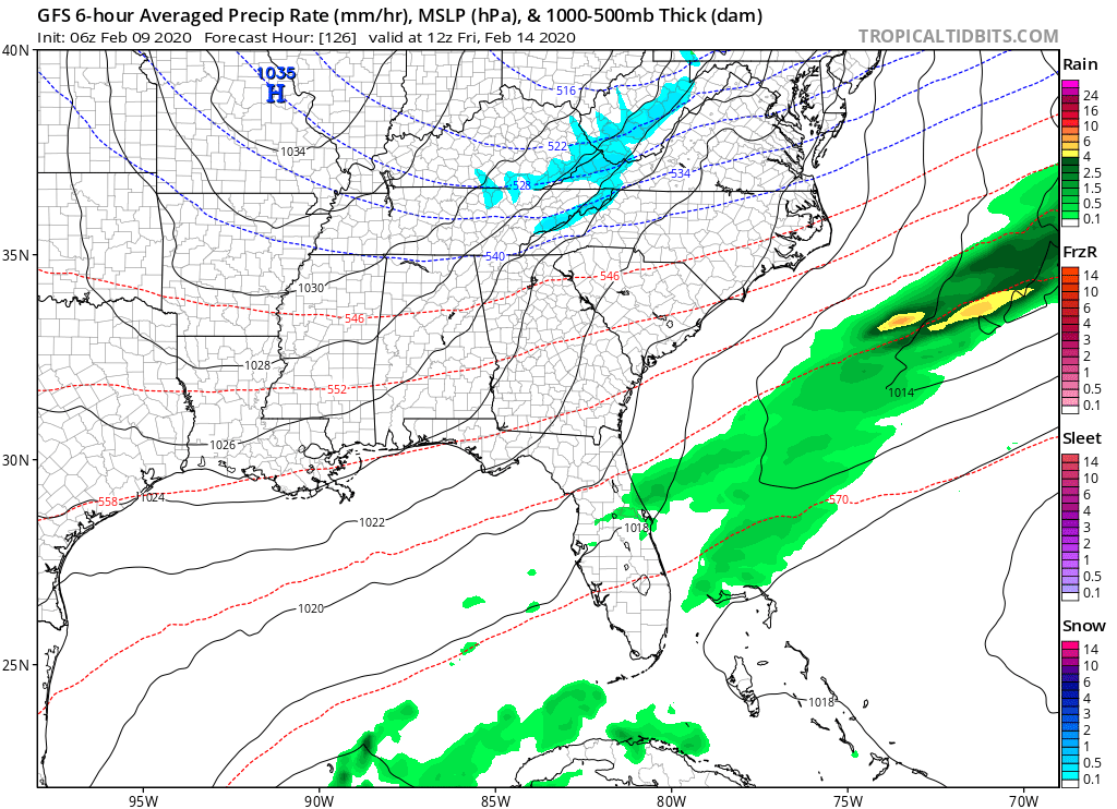
The NAM model continues to illustrate a more moist system moving into WNC compared to models like the GFS, but at this point in time it is time to stop discounting the NAM. It has shown an impactful snowstorm for most of NC for the past 2 days now without wavering. One limiting factor too accumulation could be surface temperatures. If rates do not get heavy enough, the snow could struggle to accumulate. At this point in time, I do believe that rates with be heavy enough for at least accumulation on grassy/elevated surfaces. Below you can see the most recent NAM depiction of the storm and how the precipitation progresses.

Come to where Mother Nature waved her magic wand and created one of the most natural of all wonders, Natural Hot Mineral Waters. Heated deep within the earth, these crystal clear carbonated waters are are world famous for their mineral content and l…

Come to where Mother Nature waved her magic wand and created one of the most natural of all wonders, Natural Hot Mineral Waters. Heated deep within the earth, these crystal clear carbonated waters are are world famous for their mineral content and legendary healing powers. We pipe these waters to modern outdoor jetted hot tubs that we rent privately by the hour. In addition to our World Famous Natural Hot Mineral baths the day spa offers massage, body treatments, and skin care options. Hot Springs Resort also offers accommodations and camping options. Please visit http://www.nchotsprings.com for more information.

NAM Precipitation Progression Courtesy of Tropicaltidbits.com

The trusted local accounting firm for WNC, let the team of Adrianne, Caroyl, & Naomi take care of all of your tax needs. Whether you need payroll/business accounting help or assistance filing your personal taxes, these ladies are the experts to …

The trusted local accounting firm for WNC, let the team of Adrianne, Caroyl, & Naomi take care of all of your tax needs. Whether you need payroll/business accounting help or assistance filing your personal taxes, these ladies are the experts to put your trust with. Give them a call (828) 684-7374 or visit their website http://www.kruseaccounting.com to set up your appointment today!

Another short range model that I like to refer to in these instances is the short range Canadian model. It is showing a very similar orientation of precip as it enters the mountains of WNC. Long range models did not show this northern periphery of precipitation expanding in this fashion a few days ago, but as of now they are all trending in a direction in which that north area of precipitation is somewhat expansive.

RGEM Courtesy of Tropicaltidbits.com

Call the team that keeps my truck clean at A&R Specialist! David, Matt & Harley run A&R Specialist at 621 Brevard Rd. and they are the guys to trust with your vehicle cleaning & detailing. Whether you need a deep wax every once in a …

Call the team that keeps my truck clean at A&R Specialist! David, Matt & Harley run A&R Specialist at 621 Brevard Rd. and they are the guys to trust with your vehicle cleaning & detailing. Whether you need a deep wax every once in a while or a quality clean and detail, you can feel safe putting your car in the hands of A&R Specialist! Call (828) 708-3718 to set up your appointment today. https://www.facebook.com/ARpressurewashing4/

Short Range NAM

The short-range NAM has been a little bit shy with snowfall totals as it has rolled out because it is resolving a bit of dry air aloft to begin the event. Over the past several runs that dry air continue to diminish. Here is the most recent 12z run, I will update these with the most recent runs when they become available.

3km NAM Courtesy of Tropicaltidbits.com

Contact my local trusted roofing source Matt at RedWolf Contracting Services to take care of all of your roof replacements. From shingles, to metal roofing, and even commercial rubber membrane, Matt has the resources and solutions to take care of yo…

Contact my local trusted roofing source Matt at RedWolf Contracting Services to take care of all of your roof replacements. From shingles, to metal roofing, and even commercial rubber membrane, Matt has the resources and solutions to take care of your job in a professional and cost effective manner. Call (828) 772-9778 or visit nc-roofers.com to set up your free roof inspection.

SREF Plumes

These are another short range model that I like to use when forecasting an incoming snowfall. Each line represents a different short range model run snowfall total. As you can see there is a great spread still among short range SREF members. What that tells me is that the potential for a surprise 6”+ snowfall for WNC is still certainly there. Do not let your guard down.

Power Outages Possible

If these totals verify on the higher end, power outages are certainly going to be possible here in WNC and down East with how wet the soil is and high winds. It would be wise to have some food and access to supplement heat if possible. I really don’t want to sound to big of an alarm, but the potential for this to be a larger event than many are expecting is certainly there. Look for a live video update sometime tomorrow morning as the most recent model data arrives.

AshevilleWX Initial Projected Snowfall Totals For February 20th & 21st

Short range models continue to bring in a weak low pressure along the Gulf that floods WNC with overrunning precipitation. It is still not certain just how much precipitation will fall, but it is becoming more and more apparent that an accumulating snowfall event is on the way for all of WNC & a good portions of NC. Below you can see my projected snowfall totals as of now. This map is subjected to changed, but at the moment this is my best guess for accumulation.

Come to where Mother Nature waved her magic wand and created one of the most natural of all wonders, Natural Hot Mineral Waters. Heated deep within the earth, these crystal clear carbonated waters are are world famous for their mineral content and l…

Come to where Mother Nature waved her magic wand and created one of the most natural of all wonders, Natural Hot Mineral Waters. Heated deep within the earth, these crystal clear carbonated waters are are world famous for their mineral content and legendary healing powers. We pipe these waters to modern outdoor jetted hot tubs that we rent privately by the hour. In addition to our World Famous Natural Hot Mineral baths the day spa offers massage, body treatments, and skin care options. Hot Springs Resort also offers accommodations and camping options. Please visit http://www.nchotsprings.com for more information.

Map Subject To Change As Event Approaches

The trusted local accounting firm for WNC, let the team of Adrianne, Caroyl, & Naomi take care of all of your tax needs. Whether you need payroll/business accounting help or assistance filing your personal taxes, these ladies are the experts to …

The trusted local accounting firm for WNC, let the team of Adrianne, Caroyl, & Naomi take care of all of your tax needs. Whether you need payroll/business accounting help or assistance filing your personal taxes, these ladies are the experts to put your trust with. Give them a call (828) 684-7374 or visit their website http://www.kruseaccounting.com to set up your appointment today!

Most Recent Model Data

Models continue to appear to be playing catch up to the NAM model suite which in my opinion has the best handle on the progression of the moisture. Models like the European model show very limited precipitation and surpress the system far to our south, not allowing that precipitation to blossom north. I am siding with the consistency of the NAM currently though because it has a tendency to detect small features in these overrunning events. Below you can see the most recent NAM snowfall map. Each run it has continued to increase these totals, which much be taken seriously.

NAM Snowfall Map Courtesy of Pivotalweather.com

Call the team that keeps my truck clean at A&R Specialist! David, Matt & Harley run A&R Specialist at 621 Brevard Rd. and they are the guys to trust with your vehicle cleaning & detailing. Whether you need a deep wax every once in a …

Call the team that keeps my truck clean at A&R Specialist! David, Matt & Harley run A&R Specialist at 621 Brevard Rd. and they are the guys to trust with your vehicle cleaning & detailing. Whether you need a deep wax every once in a while or a quality clean and detail, you can feel safe putting your car in the hands of A&R Specialist! Call (828) 708-3718 to set up your appointment today. https://www.facebook.com/ARpressurewashing4/

Then here is the progression of the precipitation as taken from the most recent (18z) NAM. Notice how that precipitation really develops over E TN and hammers into WNC. Then there is some backside frontogenises that enhances the trailing precipitation. This could be a long duration event.

NAM Precipitation Depiction courtesy of Tropicaltidbits.com

Contact my local trusted roofing source Matt at RedWolf Contracting Services to take care of all of your roof replacements. From shingles, to metal roofing, and even commercial rubber membrane, Matt has the resources and solutions to take care of yo…

Contact my local trusted roofing source Matt at RedWolf Contracting Services to take care of all of your roof replacements. From shingles, to metal roofing, and even commercial rubber membrane, Matt has the resources and solutions to take care of your job in a professional and cost effective manner. Call (828) 772-9778 or visit nc-roofers.com to set up your free roof inspection.

Lots Of Details Still To Nail Down

This is going to be a very difficult storm to forecast, and there could very well be some surprises with this system. I am going to do my best to provide you the most accurate forecast possible. Some tweaks will need to be made as we progress towards Thursday so stick with me and check back soon for more information. All tune in for a live Facebook update tonight at 8pm.

For the finest landscaping in Western North Carolina, contact Sam Byrnside of L & S Landscape for a free estimate.  From planting to mowing, mulching and all landscaping necessities in between contact Sam & his team!  L & S also does sal…

For the finest landscaping in Western North Carolina, contact Sam Byrnside of L & S Landscape for a free estimate. From planting to mowing, mulching and all landscaping necessities in between contact Sam & his team! L & S also does salting of roads & driveways during the winter as well as tow pull outs if you get stuck in bad weather! Just give Sam a call (828)329-6020 to schedule your appointment today!

Accumulating Snowfall Possible Around WNC On Thursday & Into Friday

A weak low will push out of Mexico into the Gulf of Mexico late Wednesday night as overrunning precipitation develops across portions of the Southeast. Several models suggest that a strip of precipitation will then push over WNC where a near frozen column will be set up on Thursday and into Friday. Other models do not develop this precipitation as far north, and therefore WNC remains dry. Below I will dissect the details of various models, and give you and idea of what I think will occur on Thursday and into Friday around WNC.

Short Range Models More Bullish On Snowfall

The Nam continues to resolve a weak low pressure moving into the Gulf and a precipitation shield blossoming in Tennessee/Georgia and moving into WNC. A massive high pressure will be in place to the north and that will provide a substantial source of cold at most levels. Below you can see the progression on the moisture on the NAM.

The trusted local accounting firm for WNC, let the team of Adrianne, Caroyl, & Naomi take care of all of your tax needs. Whether you need payroll/business accounting help or assistance filing your personal taxes, these ladies are the experts to …

The trusted local accounting firm for WNC, let the team of Adrianne, Caroyl, & Naomi take care of all of your tax needs. Whether you need payroll/business accounting help or assistance filing your personal taxes, these ladies are the experts to put your trust with. Give them a call (828) 684-7374 or visit their website http://www.kruseaccounting.com to set up your appointment today!

As you can see, that low interacts with the northern stream and even some frontogenises occurs where there is some backside snow. Other models are trending towards this solution, but at the moment they are nowhere near as strong with the northern periphery of precipitation. But, we have to give a bit of credit to the NAM solution, because the NAM has been a good model in these fast flows where lots of energy is flying around. So what are other models showing?

Call the team that keeps my truck clean at A&R Specialist! David, Matt & Harley run A&R Specialist at 621 Brevard Rd. and they are the guys to trust with your vehicle cleaning & detailing. Whether you need a deep wax every once in a …

Call the team that keeps my truck clean at A&R Specialist! David, Matt & Harley run A&R Specialist at 621 Brevard Rd. and they are the guys to trust with your vehicle cleaning & detailing. Whether you need a deep wax every once in a while or a quality clean and detail, you can feel safe putting your car in the hands of A&R Specialist! Call (828) 708-3718 to set up your appointment today. https://www.facebook.com/ARpressurewashing4/

Long Range Model Discussion

The most recent GFS actually trended towards the NAM with a much larger expansion of the northern edge of precipitation. We have to watch these trends very closely because they are notoriously under modeled and can lead to surprises around the area. Watch below and you can see how the GFS brings the low out of Mexico and as it interacts with the NorthernJet Stream the precipitation really expands over Tennessee. That will be key for all of WNC to see accumulating snowfall.

GFS Courtesy of Tropicaltidbits.com

Contact my local trusted roofing source Matt at RedWolf Contracting Services to take care of all of your roof replacements. From shingles, to metal roofing, and even commercial rubber membrane, Matt has the resources and solutions to take care of yo…

Contact my local trusted roofing source Matt at RedWolf Contracting Services to take care of all of your roof replacements. From shingles, to metal roofing, and even commercial rubber membrane, Matt has the resources and solutions to take care of your job in a professional and cost effective manner. Call (828) 772-9778 or visit nc-roofers.com to set up your free roof inspection.

Now let’s contrast that with the European model. The Euro has a similar look as the GFS showing the shot at accumulating snowfall. The problem is that these models are not showing a large amount of precipitation. They are showing snow, but not heavy snow or heavy enough to accumulate on Thursday. The NAM is showing a much more juicy system precipitation-wise. Below you can see the Euro.

Euro Courtesy of Pivotalweather.com

What you are seeing above is a swath of precipitation pushing into a frozen column around 3pm on Thursday afternoon. This seems to be arising as more and more likely scenario. Long range models are not showing a large amount of precipitation, but I think that that trend is beginning to happen.. and that we will begin to see models produce high snowfall totals over the next 36 hours for WNC. These overrunning precipitation events can be a surprise and can drop 6”+ of snow easily. I am watching this one extremely closely, and I believe this to be our best chance at accumulating snowfall all year.

Let’s take a look at another long range model. One thing that is neat with this model is the backside frontogenises that occurs. You can see that precipitation develop over E TN as the low pressure begins to really strengthen as it transfers to the Atlantic.

Come to where Mother Nature waved her magic wand and created one of the most natural of all wonders, Natural Hot Mineral Waters. Heated deep within the earth, these crystal clear carbonated waters are are world famous for their mineral content and l…

Come to where Mother Nature waved her magic wand and created one of the most natural of all wonders, Natural Hot Mineral Waters. Heated deep within the earth, these crystal clear carbonated waters are are world famous for their mineral content and legendary healing powers. We pipe these waters to modern outdoor jetted hot tubs that we rent privately by the hour. In addition to our World Famous Natural Hot Mineral baths the day spa offers massage, body treatments, and skin care options. Hot Springs Resort also offers accommodations and camping options. Please visit http://www.nchotsprings.com for more information.

GEM Model Courtesy of Tropicaltidbits.com

Main Takeaway

There is just too much uncertainty right now for me to talk about totals in your backyard, but I do believe the accumulating snowfall of 2”+ could be possible for many around WNC. These overrunning precipitation events are soo difficult to forecast, but I will do my best to keep you prepared if accumulating snowfall moves your way. Look for daily updates now, and regular live videos up until this event. AshevilleWX will be in full force covering the possibility for accumulating snowfall across WNC.

Overrunning Precipitation Could Bring Snow Showers To WNC On Thursday

A unique setup will enter the mountains of WNC beginning mid week, and there will be a chance from some overrunning precipitation to come into contact with a frozen column. These type of events are notoriously difficult to predict and the northern periphery of precipitation can be under modeled leading up to the event. So with a complicated forecast on tap, I will do my best to dissect the data and pull out the necessary details to show you the possibilities of what could be in store.

GFS Output Regarding Thursday

The GFS model continues to be bullish on the idea of a strong high pressure pushing down from Canada, and a zone of truncation developing between it and low pressure in the Gulf. This zone of truncation where high and low come together will create lift, and precipitation will likely form. Just how far north that precipitation makes it is a great uncertainty, but we have seen several surprise snows from setups just like this. Think back to December 10th of 2017, that overrunning event caught some by surprised who weren’t following AshevilleWX just yet. I am not saying this will be exactly the same, but these type setups lend credit to that possibility. That is why I have my eye on it closely. Below you can see the most recent GFS model output for late Thursday afternoon. As precipitation blossoms late Wednesday night, it will be interesting to see have far north that precipitation makes it. We very well could see light snow showers breaking out around WNC sometime Thursday. But at this moment there is still just too much uncertainty.

GFSPRecipThursday.png
Call the team that keeps my truck clean at A&R Specialist! David, Matt & Harley run A&R Specialist at 621 Brevard Rd. and they are the guys to trust with your vehicle cleaning & detailing. Whether you need a deep wax every once in a …

Call the team that keeps my truck clean at A&R Specialist! David, Matt & Harley run A&R Specialist at 621 Brevard Rd. and they are the guys to trust with your vehicle cleaning & detailing. Whether you need a deep wax every once in a while or a quality clean and detail, you can feel safe putting your car in the hands of A&R Specialist! Call (828) 708-3718 to set up your appointment today. https://www.facebook.com/ARpressurewashing4/

Euro Shows Suppression & Cold

The European model shows this system being pushed well far to our south and the moisture never making it anywhere close to WNC. In most cases I give the European model that most weight, but with these overrunning events in the past, we have seen it fail to perform. In fact, we have seen all global models fail to perform up until the snow is falling outside. Below you can see the most recent Euro model from this morning and you can see the massive expansion of high pressure that moves in. Notice how the zone where the high pressure meets the low pressure is farther south compared to the GFS.

Courtesy of Pivotalweather.com

Contact my local trusted roofing source Matt at RedWolf Contracting Services to take care of all of your roof replacements. From shingles, to metal roofing, and even commercial rubber membrane, Matt has the resources and solutions to take care of yo…

Contact my local trusted roofing source Matt at RedWolf Contracting Services to take care of all of your roof replacements. From shingles, to metal roofing, and even commercial rubber membrane, Matt has the resources and solutions to take care of your job in a professional and cost effective manner. Call (828) 772-9778 or visit nc-roofers.com to set up your free roof inspection.

That moisture could very well orient over the SW Mountains of WNC and some enhancement could occur. These small details cannot be resolved by these long range models. I will need for the the Nam 3km to get ahold of this system on Monday of Tuesday to get a better idea of how it will unfold. There are other models to consider though, let dive into them now.

ICON German Model Depiction

The most recent 12z ICON run shows that northern edge of precipitation developing at a much more efficient rate compared to previous runs. I believe that this a trend that is setting up, and we will begin to see that northern periphery of precipitation blossom more that compared to what is shown.

Come to where Mother Nature waved her magic wand and created one of the most natural of all wonders, Natural Hot Mineral Waters. Heated deep within the earth, these crystal clear carbonated waters are are world famous for their mineral content and l…

Come to where Mother Nature waved her magic wand and created one of the most natural of all wonders, Natural Hot Mineral Waters. Heated deep within the earth, these crystal clear carbonated waters are are world famous for their mineral content and legendary healing powers. We pipe these waters to modern outdoor jetted hot tubs that we rent privately by the hour. In addition to our World Famous Natural Hot Mineral baths the day spa offers massage, body treatments, and skin care options. Hot Springs Resort also offers accommodations and camping options. Please visit http://www.nchotsprings.com for more information.

as that weak low meanders through the Gulf and then transfers to the Atlantic, very limited warm air is associated aloft. This keeps any warm nose from melting snow as it falls through the atmosphere.

Short Range Models Needed

Recalling back to my forecast on the December 2017 event, I remember seeing similar moisture coming up from the Gulf up against a slightly weaker high. It will be interesting to see how much the trough tilts and how that is affected by the large high pressure to our north. It appears as though WNC will be right on the line as to where precipitation is making it through the atmosphere and where it is drying before it reaches the surface. Stick with me here at Ashevillewx and I will do my best to keep you updated on this system as it approaches and unfolds.

The trusted local accounting firm for WNC, let the team of Adrianne, Caroyl, & Naomi take care of all of your tax needs. Whether you need payroll/business accounting help or assistance filing your personal taxes, these ladies are the experts to …

The trusted local accounting firm for WNC, let the team of Adrianne, Caroyl, & Naomi take care of all of your tax needs. Whether you need payroll/business accounting help or assistance filing your personal taxes, these ladies are the experts to put your trust with. Give them a call (828) 684-7374 or visit their website http://www.kruseaccounting.com to set up your appointment today!

After Another Round Of Storms/Rainfall, Teens Likely For Many In WNC Saturday Morning

One more round of rainfall is in store for the mountains of WNC, and then a strong cold front will bring temperatures that cripple any early rising vegetation. Some high elevation locations (above 5000’ on the NC/TN border) will see Northwest flow snow from this frontal passage early Friday am, but as radiational cooling takes effect on Friday night, temps drop into the upper teens by Saturday morning. So, it would be wise on Valentines Day if you are out and about to bring along a heavy winter coat as temperatures plummet.

How Much Rain Is Expected In The Next 24 Hours?

Another inch or so can be expected for SW Mountain locations, and locations along The Blue Ridge Escarpment, but around Asheville I am expecting less than a half inch through the end of the week. This is a lot less compared to what models had previously shown, and that is a great thing! Below you can see the most recent Nam 3km total precipitation through Thursday morning.

Nam 3km Courtesy of Weathermodels.com

Contact my local trusted roofing source Matt at RedWolf Contracting Services to take care of all of your roof replacements. From shingles, to metal roofing, and even commercial rubber membrane, Matt has the resources and solutions to take care of yo…

Contact my local trusted roofing source Matt at RedWolf Contracting Services to take care of all of your roof replacements. From shingles, to metal roofing, and even commercial rubber membrane, Matt has the resources and solutions to take care of your job in a professional and cost effective manner. Call (828) 772-9778 or visit nc-roofers.com to set up your free roof inspection.

Strong Winds Likely As Front Passes Through On Thursday AM

Short range models continue to indicate that very strong winds will be possible with the line of storms that moves through early Tomorrow morning. For the past several runs the Nam 3km has shown gusts over 50mph being possible around 3am in Buncombe County. Please secure outdoor accessories in preparation for these gusts! Below you can see the most recent Nam 3km peak wind gusts for 3am tomorrow morning. Notice how the total over the Asheville airport is 52mph! That is pretty impressive. On average these totals tend to be a bit high, but gusts in the mid 40’s certainly seem likely.

Nam 3km Wind Gusts Courtesy of Weathermodels.com

Come to where Mother Nature waved her magic wand and created one of the most natural of all wonders, Natural Hot Mineral Waters. Heated deep within the earth, these crystal clear carbonated waters are are world famous for their mineral content and l…

Come to where Mother Nature waved her magic wand and created one of the most natural of all wonders, Natural Hot Mineral Waters. Heated deep within the earth, these crystal clear carbonated waters are are world famous for their mineral content and legendary healing powers. We pipe these waters to modern outdoor jetted hot tubs that we rent privately by the hour. In addition to our World Famous Natural Hot Mineral baths the day spa offers massage, body treatments, and skin care options. Hot Springs Resort also offers accommodations and camping options. Please visit http://www.nchotsprings.com for more information.

Upper Teens Possible Saturday AM

The European model indicates that temperatures on Saturday morning could drop into the upper teens around WNC after the cold front move through. This would devastate any early vegetation that has made its Spring arrival already. If you have sensitive plants that are susceptible to frost, it would be smart to cover them on Friday night.. but I am afraid you face an uphill battle over the next month and a half. Below you can see temperatures per the ECMWF at 8am on Saturday morning around WNC.

Courtesy of Weathermodels.com

The trusted local accounting firm for WNC, let the team of Adrianne, Caroyl, & Naomi take care of all of your tax needs. Whether you need payroll/business accounting help or assistance filing your personal taxes, these ladies are the experts to …

The trusted local accounting firm for WNC, let the team of Adrianne, Caroyl, & Naomi take care of all of your tax needs. Whether you need payroll/business accounting help or assistance filing your personal taxes, these ladies are the experts to put your trust with. Give them a call (828) 684-7374 or visit their website http://www.kruseaccounting.com to set up your appointment today!

Sunday Choice Day Of The Weekend

Sunday appears to be the best weather day for outdoor activities this weekend with highs expected in the mid to upper 50’s on Sunday afternoon and partly cloudy skies. Below you can see the most recent GFS model and its temperatures depiction for Sunday afternoon.

GFS Sunday High Temps Courtesy of Weathermodels.com

Call the team that keeps my truck clean at A&R Specialist! David, Matt & Harley run A&R Specialist at 621 Brevard Rd. and they are the guys to trust with your vehicle cleaning & detailing. Whether you need a deep wax every once in a …

Call the team that keeps my truck clean at A&R Specialist! David, Matt & Harley run A&R Specialist at 621 Brevard Rd. and they are the guys to trust with your vehicle cleaning & detailing. Whether you need a deep wax every once in a while or a quality clean and detail, you can feel safe putting your car in the hands of A&R Specialist! Call (828) 708-3718 to set up your appointment today. https://www.facebook.com/ARpressurewashing4/

Long Range Models Indicate Blocking

Pattern Setting Up

What is a blocking pattern? This is when a large high pressure moves down from the arctic, and moves in tandem with a low pressure to its south. The high pressure works as a sort of atmospheric blocker and does not alloy the low pressure to naturally move north. These patterns are more conducive to Southern snowfalls. That doesn’t mean that a snow will occur, but it does appear as though we will enter a somewhat cooler pattern to end February. For snow lovers, you need that cold to be moving in and out to increase the chance for snowfall. So, still 7+ days out, but this time next week I feel will be much more interesting weather-wise compared to this week.

GFS Courtesy of Tropicaltidbits.com

Several Rounds Of Rainfall In Store For WNC This Week With Flash Flooding Possible Again

A river of moisture will set up in the atmosphere over the southeast during the next four days, and that will bring ample amounts of rainfall to the entire area. Many locations will see over 2.5” of rainfall through Thursday evening, and isolated locations in SW WNC and along the Blue Ridge Escarpment could see over 6”. This will fall on already saturated soil that just received 4”+ of rainfall over the past 4 days. Several concerns are increasing around WNC including the threat for mudslides. If this pattern continues, slopes around the area will continue to be jeopardized. Below you can see the most recent GFS model precipitation output for the next 5 days. Notice how there are higher totals around locations like Andrews & Franklin compared to Asheville. That is due to the Southwest enhancement that naturally occurs when precipitation infiltrates from this direction.

GFS Precipitation Totals Thru Thursday Evening Courtesy of Weathermodels.com

GFS Precipitation Totals Thru Thursday Evening Courtesy of Weathermodels.com

Come to where Mother Nature waved her magic wand and created one of the most natural of all wonders, Natural Hot Mineral Waters. Heated deep within the earth, these crystal clear carbonated waters are are world famous for their mineral content and l…

Come to where Mother Nature waved her magic wand and created one of the most natural of all wonders, Natural Hot Mineral Waters. Heated deep within the earth, these crystal clear carbonated waters are are world famous for their mineral content and legendary healing powers. We pipe these waters to modern outdoor jetted hot tubs that we rent privately by the hour. In addition to our World Famous Natural Hot Mineral baths the day spa offers massage, body treatments, and skin care options. Hot Springs Resort also offers accommodations and camping options. Please visit http://www.nchotsprings.com for more information.

Where Will The Most Rain Fall?

With this type systems, where there is great Southwest push out ahead of the main front, locations along the Blue Ridge Escarpment will rake in the most precipitation. That means that places like Lake Toxaway, Highlands, Cashiers, Brevard, Rosman and other locations along the NC/SC border should be on alert for mudslides and the possibility for flash flooding as the week moves on. Looking at short range models, the Nam 3km shows over 5” of rain falling in the above mentioned locations through Tuesday afternoon. This is extremely concerning to me. Below you can see the most recent Nam 3km precipitation amounts, and several locations along the Escarpment crest that 4” mark.

Nam 3km Precipitation Totals Thru Tuesday Afternoon Courtesy of Weathermodels.com

The trusted local accounting firm for WNC, let the team of Adrianne, Caroyl, & Naomi take care of all of your tax needs. Whether you need payroll/business accounting help or assistance filing your personal taxes, these ladies are the experts to …

The trusted local accounting firm for WNC, let the team of Adrianne, Caroyl, & Naomi take care of all of your tax needs. Whether you need payroll/business accounting help or assistance filing your personal taxes, these ladies are the experts to put your trust with. Give them a call (828) 684-7374 or visit their website http://www.kruseaccounting.com to set up your appointment today!

Where Will Flash Flooding Be Most Likely?

A topographic map of the Southwest Mountains of WNC explaining how precipitation enhances when it approaches from the Southwest.

From the topographic map above, you can see how when the flow of moisture sets up from the Southwest, it is enhanced. Areas that are nestled close to the Blue Ridge Mountains experience more rainfall compared to those that are tucked in the valleys between the Blue Ridge Mountains & The Appalachians. Locations like the Nantahala Gorge are very susceptible to mudslides and traveling through these locations over the next 4-5 days should be done with extreme caution.

Call the team that keeps my truck clean at A&R Specialist! David, Matt & Harley run A&R Specialist at 621 Brevard Rd. and they are the guys to trust with your vehicle cleaning & detailing. Whether you need a deep wax every once in a …

Call the team that keeps my truck clean at A&R Specialist! David, Matt & Harley run A&R Specialist at 621 Brevard Rd. and they are the guys to trust with your vehicle cleaning & detailing. Whether you need a deep wax every once in a while or a quality clean and detail, you can feel safe putting your car in the hands of A&R Specialist! Call (828) 708-3718 to set up your appointment today. https://www.facebook.com/ARpressurewashing4/

When Will Rain Move In?

Below you can see the simulated radar from the 3km Nam, and scattered showers will be possible during the day on Monday, but as Monday night progress those showers will increase into a steady rainfall. By Tuesday Morning it appears that strong lift will be in the area and locations along the Blue Ridge Escarpment could be experience very heavy rainfall.

3km Nam Simulated Radar Courtesy of Weathermodels.com

Please be mindful of this when traveling around WNC on Tuesday Morning, ponding on the roadways appears to be certain and several streams and rivers could very well be out of their banks. I say this often, but please turn around and don’t drown. There are so many alternative routes here in the mountains of WNC.

Contact my local trusted roofing source Matt at RedWolf Contracting Services to take care of all of your roof replacements. From shingles, to metal roofing, and even commercial rubber membrane, Matt has the resources and solutions to take care of yo…

Contact my local trusted roofing source Matt at RedWolf Contracting Services to take care of all of your roof replacements. From shingles, to metal roofing, and even commercial rubber membrane, Matt has the resources and solutions to take care of your job in a professional and cost effective manner. Call (828) 772-9778 or visit nc-roofers.com to set up your free roof inspection.

Another Round of Rain Through Thursday

This push of moisture will retreat after Tuesday, and another round of rain will Wednesday and into Thursday with flash flooding concerns again for the same areas. This week is going to be an absolutely nasty week around WNC to be honest. If you have desires to complete outdoor activities, Sunday (today) and Monday are going to be your best days to accomplish anything. After Tuesday, your mud is going to be wet again and any outdoor activity will be slippery. Trust me I know!! Many locations could break February monthly rainfall records this week already! Needless to say this has been a very wet winter, and if you read my winter weather forecast for this year I indicated that. I also indicated that below average snowfall would be likely. There will still be chances for snowfall as we move through late February, but any chances during this week will be of the Northwest flow variety on Friday AM.

Northwest Flow Snow Possible Friday AM

High elevations be on guard for you next snowfall event that will come on Friday morning in the way of Northwest flow on the backside of the system that will affect the area all week. Finally Thursday afternoon the frontal passage will occur, and temperatures will plummet late Thursday. Winds will pick up and moisture will be strained out along the backside. Elevations above 3500’ on the NC/TN border will see some form of accumulating snowfall. Details still need to be hammered down, but this is the next chance for accumulating snowfall in the mountains of WNC. Check back soon for another update, and more details regarding this flow.

GFS Friday AM Courtesy of Tropicaltidbits.com

GFS Friday AM Courtesy of Tropicaltidbits.com

Accumulating Snowfall Possible For Many In WNC As Saturday Progresses

a shortwave front will push into WNC beginning in the far SW counties relatively early in the morning. Those locations stand the best chance to see accumulating snowfall because the precipitation will move in at the best time for accumulation. Then this precipitation will blossom across the rest of WNC. Lower totals can be expected away from the Blue Ridge Escarpment as rates will be lower, and therefore accumulation chances are less likely. Below you can see my best guess at the moment for accumulation.

The trusted local accounting firm for WNC, let the team of Adrianne, Caroyl, & Naomi take care of all of your tax needs. Whether you need payroll/business accounting help or assistance filing your personal taxes, these ladies are the experts to …

The trusted local accounting firm for WNC, let the team of Adrianne, Caroyl, & Naomi take care of all of your tax needs. Whether you need payroll/business accounting help or assistance filing your personal taxes, these ladies are the experts to put your trust with. Give them a call (828) 684-7374 or visit their website http://www.kruseaccounting.com to set up your appointment today!

When Will Precipitation Move In?

Snowfall will begin in the early hours Saturday morning in NE GA and then that precipitation will move into WNC. Depending on the orientation of this precipitation will determine who exactly sees the heaviest band of snowfall. Right now models indicate that precipitation will move in around to far SW WNC around 7-8am and then spread NE. It should arrive to Asheville around 10am or so, and I expect at least a heavy burst of snow for 20-30 minutes. The closer you get to the NC/SC border, the longer I believe that burst will last.

Call the team that keeps my truck clean at A&R Specialist! David, Matt & Harley run A&R Specialist at 621 Brevard Rd. and they are the guys to trust with your vehicle cleaning & detailing. Whether you need a deep wax every once in a …

Call the team that keeps my truck clean at A&R Specialist! David, Matt & Harley run A&R Specialist at 621 Brevard Rd. and they are the guys to trust with your vehicle cleaning & detailing. Whether you need a deep wax every once in a while or a quality clean and detail, you can feel safe putting your car in the hands of A&R Specialist! Call (828) 708-3718 to set up your appointment today. https://www.facebook.com/ARpressurewashing4/

How Long Will Snowfall Last?

Snow showers could persist in some locations around WNC until sundown, and then a bit of Northwest flow moisture could move through the higher elevations. Below you can see the most recent Nam 3km radar depiction through early Monday AM.

3km Nam Radar Depiction Courtesy of Weathermodels.com

Contact my local trusted roofing source Matt at RedWolf Contracting Services to take care of all of your roof replacements. From shingles, to metal roofing, and even commercial rubber membrane, Matt has the resources and solutions to take care of yo…

Contact my local trusted roofing source Matt at RedWolf Contracting Services to take care of all of your roof replacements. From shingles, to metal roofing, and even commercial rubber membrane, Matt has the resources and solutions to take care of your job in a professional and cost effective manner. Call (828) 772-9778 or visit nc-roofers.com to set up your free roof inspection.

More Rainfall Moves In Early Next Week

That is right, another couple of inches of rainfall is on the the way next week in the from on an extend front. Moisture will begin to move into WNC on Monday, and showers will be possible all the way through Thursday. Check out the extended forecast per the most recent European model. You can see that over 2” of rainfall is expected through next weekend. So it is for sure going to be wet, the rain does not appear to be going anywhere.

Courtesy of Weathermodels.com

Come to where Mother Nature waved her magic wand and created one of the most natural of all wonders, Natural Hot Mineral Waters. Heated deep within the earth, these crystal clear carbonated waters are are world famous for their mineral content and l…

Come to where Mother Nature waved her magic wand and created one of the most natural of all wonders, Natural Hot Mineral Waters. Heated deep within the earth, these crystal clear carbonated waters are are world famous for their mineral content and legendary healing powers. We pipe these waters to modern outdoor jetted hot tubs that we rent privately by the hour. In addition to our World Famous Natural Hot Mineral baths the day spa offers massage, body treatments, and skin care options. Hot Springs Resort also offers accommodations and camping options. Please visit http://www.nchotsprings.com for more information.

Watch Snow Fall Around WNC On The Live Webcams

Snow Showers Likely For Many In WNC Friday, Then Another Chance Arrives Saturday Afternoon

The heavy rainfall is finally moving out of WNC for the most part and Northwest flow moisture will begin to move through by early tomorrow morning. An upper level low associated with this backside will make things interesting for many as winds get up, and moisture is strained out. Snowfall will be likely for most locations north of I-40 sometime Friday morning, and we could even see those snow showers push to isolated locations south of I-40. Elevations above 3000’ are likely to see 1”-3” with some isolated pockets of 5”+ above 5000’. A dusting to 1” can also not be ruled out for locations north of I-40 and below 3000’. Below you can see a depiction of the Nam 3k early tomorrow morning around 7am.

Courtesy of Weathermodels.com

Call the team that keeps my truck clean at A&R Specialist! David, Matt & Harley run A&R Specialist at 621 Brevard Rd. and they are the guys to trust with your vehicle cleaning & detailing. Whether you need a deep wax every once in a …

Call the team that keeps my truck clean at A&R Specialist! David, Matt & Harley run A&R Specialist at 621 Brevard Rd. and they are the guys to trust with your vehicle cleaning & detailing. Whether you need a deep wax every once in a while or a quality clean and detail, you can feel safe putting your car in the hands of A&R Specialist! Call (828) 708-3718 to set up your appointment today. https://www.facebook.com/ARpressurewashing4/

High Wind Gust Possible Into Tomorrow

Winds could gust over 30mph in many locations as this upper level low moves over WNC. It would be wise to secure any outdoor accessories if possible tonight. Below you can see the most recent NAM 3km wind gust map at 7am tomorrow morning. As you can see gusts around Boone could reach close to 40mph in isolated locations, and will gust even higher than that as you rise in elevation.

Nam 3km Wind Gusts Courtesy of Weathermodels.com

Contact my local trusted roofing source Matt at RedWolf Contracting Services to take care of all of your roof replacements. From shingles, to metal roofing, and even commercial rubber membrane, Matt has the resources and solutions to take care of yo…

Contact my local trusted roofing source Matt at RedWolf Contracting Services to take care of all of your roof replacements. From shingles, to metal roofing, and even commercial rubber membrane, Matt has the resources and solutions to take care of your job in a professional and cost effective manner. Call (828) 772-9778 or visit nc-roofers.com to set up your free roof inspection.

Who Will See Accumulation From This First Round?

Higher elevations (above 3500’) are where accumulation is most likely to occur, but I believe that snow showers will certainly be possible for many. Where those heavy bands break containment from the mountains is really difficult to differentiate, but we could even see surprise accumulation in valley locations as Friday commute kicks off (Haywood Co?). Below you can see the most recent Nam 3km snowfall accumulation through Saturday morning. It is important that I stop this before it shows the next event, which does show accumulation for most valley areas.

3km Nam Snowfall Map Courtesy of Weathermodels.com

Come to where Mother Nature waved her magic wand and created one of the most natural of all wonders, Natural Hot Mineral Waters. Heated deep within the earth, these crystal clear carbonated waters are are world famous for their mineral content and l…

Come to where Mother Nature waved her magic wand and created one of the most natural of all wonders, Natural Hot Mineral Waters. Heated deep within the earth, these crystal clear carbonated waters are are world famous for their mineral content and legendary healing powers. We pipe these waters to modern outdoor jetted hot tubs that we rent privately by the hour. In addition to our World Famous Natural Hot Mineral baths the day spa offers massage, body treatments, and skin care options. Hot Springs Resort also offers accommodations and camping options. Please visit http://www.nchotsprings.com for more information.

Trailing Wave To Bring Accumulating Snowfall Saturday Afternoon To Much Of WNC

This trailing wave will take advantage of the cold air that has already been laid down, and I believe that a small accumulating snowfall event will be possible for many. Locations in SW WNC like Franklin & Andrews appear to have the best shot at accumulating snowfall at this point in time, but some models show this precipitation blossoming. Below you can see the Nam 3km radar depiction Saturday afternoon.

Nam 3km Radar Courtesy of Weathermodels.com

The trusted local accounting firm for WNC, let the team of Adrianne, Caroyl, & Naomi take care of all of your tax needs. Whether you need payroll/business accounting help or assistance filing your personal taxes, these ladies are the experts to …

The trusted local accounting firm for WNC, let the team of Adrianne, Caroyl, & Naomi take care of all of your tax needs. Whether you need payroll/business accounting help or assistance filing your personal taxes, these ladies are the experts to put your trust with. Give them a call (828) 684-7374 or visit their website http://www.kruseaccounting.com to set up your appointment today!

Who Sees Accumulation With Trailing Wave?

A whole different crowd compared to Fridays event will likely see accumulation from on Saturday afternoon. Several locations along the Blue Ridge Escarpment could see a quick burst of snow like Brevard & Hendersonville. Locations like Franklin & Sylva also could see some form of accumulation with this wave, but I am still not certain if temps will support that. The column of air does appear to be frozen though so if the wave moves through it will likely at least drop a few snow flurries for many. Check back soon as I continue to analyze short range data. Below is the Nam 3km most recent extended snowfall map showing accumulation possible in many valley locations Saturday.

Nam3km Snowfall Courtesy of Weathermodels.com

Flooding Rainfall Expected For WNC On Thursday, Then Another Chance For Snow Showers This Weekend

A strong low pressure system will push into WNC on Thursday morning potentially causing flash flooding problems for many locations. As this front moves through, locations around WNC will likely pick up over 1.5” of rainfall, with isolated locations seeing over 3”. This will quickly push streams and rivers out of their banks in some areas, due to how saturated the current ground already is. As this low moves through, a strong jet stream will set up directly over WNC. These strong jets are known to be very efficient moisture transport mechanisms, and can quickly bring large amounts of rainfall to the mountains of WNC. I’ll show you that jet stream below, but first let’s look at the total precipitation for the next three days portrayed by the most recent GFS.

GFS Courtesy of Weathermodels.com

Contact my local trusted roofing source Matt at RedWolf Contracting Services to take care of all of your roof replacements. From shingles, to metal roofing, and even commercial rubber membrane, Matt has the resources and solutions to take care of yo…

Contact my local trusted roofing source Matt at RedWolf Contracting Services to take care of all of your roof replacements. From shingles, to metal roofing, and even commercial rubber membrane, Matt has the resources and solutions to take care of your job in a professional and cost effective manner. Call (828) 772-9778 or visit nc-roofers.com to set up your free roof inspection.

Who Will See The Most Rainfall?

The typical locations along the Blue Ridge Escarpment will likely see the highest totals, but locations like Franklin & Andrews will also get hammered by this flow. Even around Asheville I expect a hefty dose of rain that could even push streams and rivers out around town. Thursday morning we could potentially wake up to a mess. Below you can see that Jet Stream that I have been discussing as it sets up over WNC Thursday morning.

500mb Jet Streak Courtesy of Pivotalweather.com

Come to where Mother Nature waved her magic wand and created one of the most natural of all wonders, Natural Hot Mineral Waters. Heated deep within the earth, these crystal clear carbonated waters are are world famous for their mineral content and l…

Come to where Mother Nature waved her magic wand and created one of the most natural of all wonders, Natural Hot Mineral Waters. Heated deep within the earth, these crystal clear carbonated waters are are world famous for their mineral content and legendary healing powers. We pipe these waters to modern outdoor jetted hot tubs that we rent privately by the hour. In addition to our World Famous Natural Hot Mineral baths the day spa offers massage, body treatments, and skin care options. Hot Springs Resort also offers accommodations and camping options. Please visit http://www.nchotsprings.com for more information.

Northwest Flow Snow Possible Friday For High Elevations

Northwest flow will pick up on the backside, and favored Northwest Flow areas should begin to pick up isolated accumulation sometime Friday morning. Around 1”-3” can be expected above 4000’ on the NC/TN border. Below you can see the most recent GFS model, notice how it produces the streamers along the Appalachian Mountains? Thats a Northwest Flow signature.

GFS Courtesy of Tropicaltidbits.com

The trusted local accounting firm for WNC, let the team of Adrianne, Caroyl, & Naomi take care of all of your tax needs. Whether you need payroll/business accounting help or assistance filing your personal taxes, these ladies are the experts to …

The trusted local accounting firm for WNC, let the team of Adrianne, Caroyl, & Naomi take care of all of your tax needs. Whether you need payroll/business accounting help or assistance filing your personal taxes, these ladies are the experts to put your trust with. Give them a call (828) 684-7374 or visit their website http://www.kruseaccounting.com to set up your appointment today!

Another Front Likely Saturday Could Bring Snow To Most WNC Locations

A shortwave front appears to run the trough following the strong storm that brings several inches of rainfall to WNC. This shortwave will likely move in sometime Saturday, and it will be able to take advantage of a cold front that has already laid down really cold air. As it develops on the tail end, some models show a blossoming of precipitation over a frozen column in WNC. Several models indicate this wave to be possible including the GFS, Euro, & CMC models, so the threat has legitimacy. I am just not exactly sure how it will work out though. The European ensemble indicated that an average of around an inch of snow would be possible for the Asheville airport through Sunday morning with some variations showing higher totals. Below you can see a depiction of what the GFS has shown for the past few runs.

Courtesy of Tropicaltidbits.com

Call the team that keeps my truck clean at A&R Specialist! David, Matt & Harley run A&R Specialist at 621 Brevard Rd. and they are the guys to trust with your vehicle cleaning & detailing. Whether you need a deep wax every once in a …

Call the team that keeps my truck clean at A&R Specialist! David, Matt & Harley run A&R Specialist at 621 Brevard Rd. and they are the guys to trust with your vehicle cleaning & detailing. Whether you need a deep wax every once in a while or a quality clean and detail, you can feel safe putting your car in the hands of A&R Specialist! Call (828) 708-3718 to set up your appointment today. https://www.facebook.com/ARpressurewashing4/

Small Variations, Big Changes

If this shortwave decides to cut before the Appalachians, this will limit the chance for snowfall around WNC dramatically. One thing that was interesting overnight was how the European ensemble moved towards a more snowfall/less rain event. Today will be an interesting day of model watching, and like last week.. we will need for short range models to get ahold of this system soon to give us the best idea of what is possible. Check back soon for more information and stay dry!!

Northwest Flow Snow Likely For Many In WNC Tomorrow Afternoon & Into Early Sunday Morning

An Upper Level Low will push through on the backside of this event, and that should bring accumulating snowfall to those within 15 miles of the NC/TN border… especially above 3000’. Below you can see the Nam 3km radar depiction at 10pm tomorrow evening.

Nam 3km Precipitation Type Courtesy of Weathermodels.com

Come to where Mother Nature waved her magic wand and created one of the most natural of all wonders, Natural Hot Mineral Waters. Heated deep within the earth, these crystal clear carbonated waters are are world famous for their mineral content and l…

Come to where Mother Nature waved her magic wand and created one of the most natural of all wonders, Natural Hot Mineral Waters. Heated deep within the earth, these crystal clear carbonated waters are are world famous for their mineral content and legendary healing powers. We pipe these waters to modern outdoor jetted hot tubs that we rent privately by the hour. In addition to our World Famous Natural Hot Mineral baths the day spa offers massage, body treatments, and skin care options. Hot Springs Resort also offers accommodations and camping options. Please visit http://www.nchotsprings.com for more information.

Who Will See Accumulation?

This will be a somewhat typical Northwest flow snow event where locations above 3000’ close to NC/TN border receive 1”-3” with isolated higher totals, and then a dusting-1” can’t be ruled out below that. Taking a look at the Nam 3km snowfall map, there are some decent totals showing up in the highest elevations. Usually I like to cut these totals in half to give a realistic idea of what could be possible. This models is just getting ahold of the Upper Level Low, so it will be interesting to watch as it changes and resolves the solution over the next 24 hours.

Nam 3km Snowfall Totals Courtesy of Weathermodels.com

The trusted local accounting firm for WNC, let the team of Adrianne, Caroyl, & Naomi take care of all of your tax needs. Whether you need payroll/business accounting help or assistance filing your personal taxes, these ladies are the experts to …

The trusted local accounting firm for WNC, let the team of Adrianne, Caroyl, & Naomi take care of all of your tax needs. Whether you need payroll/business accounting help or assistance filing your personal taxes, these ladies are the experts to put your trust with. Give them a call (828) 684-7374 or visit their website http://www.kruseaccounting.com to set up your appointment today!

Will Asheville See Flurries From This?

There are several things that I begin to observe when trying to decide if Northwest Flow snow will push all the way into Asheville. The first are how strong are the wind gusts at the surface. This is important because winds need to be above 25mph or so for snowflakes to be pushed out of the higher elevations and into the French Broad River Valley. So lets take a look at the most recent Nam 3km surface wind gusts around 2am tomorrow morning.

Wind Gusts at 2am Sunday Morning Courtesy of Weathermodels.com

Call the team that keeps my truck clean at A&R Specialist! David, Matt & Harley run A&R Specialist at 621 Brevard Rd. and they are the guys to trust with your vehicle cleaning & detailing. Whether you need a deep wax every once in a …

Call the team that keeps my truck clean at A&R Specialist! David, Matt & Harley run A&R Specialist at 621 Brevard Rd. and they are the guys to trust with your vehicle cleaning & detailing. Whether you need a deep wax every once in a while or a quality clean and detail, you can feel safe putting your car in the hands of A&R Specialist! Call (828) 708-3718 to set up your appointment today. https://www.facebook.com/ARpressurewashing4/

Winds will be gusting to around 30mph so it does appear that wind gusts will be adequate for flakes to push at least as far as Weaverville. Possibly farther. The next thing that I will observe is the dew point in relation to the temperature. The air has to be somewhat saturated for flakes to make it out of the higher elevations without drying up! Below you can see the Relative Humidity values which tell you how saturated the air is. For flakes to not dry up you want to see values above 70%. Indeed this model is showing Relative Humidity at 79% on Sunday morning at 2am. That is very interesting to me. With high wind gusts, and a dew point that is close to the actual temperature, these snow showers could even push into Asheville.

Relative Humidity Values At 2am Sunday Morning Courtesy of Weathermodels.com

Relative Humidity Values At 2am Sunday Morning Courtesy of Weathermodels.com

Increasing Possibility For Flurries Around Downtown Asheville

So now that I have laid out the maps for you to dissect the possibility of snow in Asheville tomorrow evening, its evident that this is a complicated setup. Just as many of our weather systems are complicate (like today), tomorrows backend snowfall will be somewhat unpredictable. Many locations that missed out on snow today could pick up snowfall tomorrow night. Unfortunately for locations like Sylva & Franklin, this doesn’t appear to be your system. Moving back towards Asheville, locations like Maggie Valley, Waynesville & Canton could pick up a dusting to an inch with this Upper Level Low, and locations in the Northern Mountains like Blowing Rock & Boone could also pick up an inch. If trends continue, even Downtown Asheville could possibly see a dusting from this, but as of now I am just not certain.

Contact my local trusted roofing source Matt at RedWolf Contracting Services to take care of all of your roof replacements. From shingles, to metal roofing, and even commercial rubber membrane, Matt has the resources and solutions to take care of yo…

Contact my local trusted roofing source Matt at RedWolf Contracting Services to take care of all of your roof replacements. From shingles, to metal roofing, and even commercial rubber membrane, Matt has the resources and solutions to take care of your job in a professional and cost effective manner. Call (828) 772-9778 or visit nc-roofers.com to set up your free roof inspection.

Spring-Like Temps Return To WNC

Are you ready for the upper 60’s to low 70’s again? That is right Sunday & Monday will both be extremely warm days as a ridge develops in the Southern Atlantic. This will push in unseasonably warm air to all of WNC and many locations will reach for the 70’s. This appears to be an extended warm up lasting most of next week, but rainfall will be back in the forecast to end next week. Below you can see the temperature spread for the next several days per the most recent European model.

Courtesy of Weathermodels.com

More Rain Likely Thursday

The rainfall will continue as a persistent stream of moisture from the Gulf continues to parade through. Looking ahead to Wednesday, Thursday, & Friday.. it appears that another soggy end to a week is on tap. I hate to be the bearer of bad news, so please don’t shoot the messenger, but another couple of inches of rain is on the way to WNC and flash flooding could again be possible Thursday & Friday. I will be sure to keep you updated, so check back here for more updates and have a great weekend!