Snowfall Chances For WNC This Weekend Increasing

Snowfall Chances For WNC This Weekend Increasing, Models Struggling To Nail Down Upper Level Low Track

Models are beginning to resolve an Upper Level Low that could cause problems around WNC this weekend. A lot of information remain uncertain, but on recent models, the trend has been for that Upper Level Low to track farther South. With a further South track, this would bring the potential for the surface low to be captured by the parent Upper Level Low. If it sounds complicated, that’s because it is! We have a ton of moving pieces with this one and it has boom or bust potential. For those of you South of Asheville though this is a pattern you can get snow in!

GFS Model

Below ill be showing what the most recent GFS model shows. As you can see, it has some potential for snow, but really bombs the system out once it exits WNC. The previous run (6z) had the ULL going right over WNC so there is some variability. Ill also attach below this the most recent GFS Ensemble that details out how the 30 member snowfall maps panned out on the 12z run.

12z GFS Courtesy of Pivotalweather.com

GFS Ensemble Snowfall

12z GEFS Snowfall Courtesy of Weathermodels.com

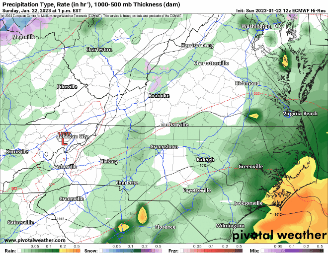
As you can see above there is a wide variation of weather solutions that could occur for late Saturday & into Sunday. This is the time frame we are looking at. Earlier models suggested that this event would be a Northwest flow snow, but recent trends with the Upper Level Energy have lead me to believe that something larger could be on tap. For comparison lets check out the most recent European run (12z) below.

12z European Model

Below you can see the most recent European model. This models has been trending towards what the GFS has shown the past two runs. Notice how important it is for the Upper Level Low to go negative tilt before it arrives in WNC. That will crack back the moisture to a more favorable direction to enter WNC as snowfall.

12z European Model Courtesy of Pivotalweather.com

Summary

There still remains a bit of uncertainty with this system. That being said, current trends are towards some form of snowfall on Saturday night and into Sunday. How much and where exactly it falls will begin to become the focus, but as of now I am still trying to determine if snow will actually occur. These Upper Level Lows are very tricky so bear with me on this forecast and ill do my best to get it correct for you by Friday evening!

Northwest Flow To Bring Snow To Asheville For AM Commute Monday

Northwest Flow Could Cause Morning Commute Troubles For Some Across WNC

Who Is Most Likely To See Snow?

Locations above 3500’ in favored Northwest Flow areas stand the best chance to see accumulation from this event, but as mid level saturate snow levels will likely drop to around 2000’ as the sun rises.

Timing?

Snow will begin around midnight in the highest elevations and by 5am we could be expereiencing streamers breaking containment even around the Asheville area. That is why I am projecting a dusting-1” around Downtown Asheville. Locations to the South of Asheville could experience some flurries from this as well but if you struggled to see accumulation during the last event, the story will be similar here. Check out the HRRR model below to see how the accumulation piles up.

HRRR Snowfall Accumulation Courtesy of Pivotalweather.com

How Long Will Snow Last?

It depends on your location, but snowfall will taper off around the Asheville area by 10am-11am in my opinion. Locations above 3500’ within 15 miles of the NC/TN border could see snowfall through sundown though with roadways staying slick throughout the day!

Looking Ahead!

Heavy rain will be possible for most on Wednesday as a strong front moves through. Then focus will turn to another round of Northwest Flow snow that will bring another round of snow to the favored areas. Check out the most recent European model below. It still remains to be seen as to whether or not this system will affect Downtown Asheville but check back soon for more information!

12z European Model Courtesy of Pivotalweather.com


Winter Storm Advisory In Place For Many In WNC For Tomorrow, Snow Possible Early Monday

NWS Posts Winter Storm Advisories For Many In WNC

Courtesy of The National Weather Service

What Is The Advisory For??

As a weak front moves in cold air will be in place above 3500’ for freezing rain to fall. Ice could accumulate on trees and grassy surfaces, but roadways could also get a little slick where ice accretion continues through the day. Below you can see how the NAM 3km brings in precipitation over the next two days. Notice the pink that shows up around those high peaks.

How Much Ice Is Expected?

For many of you, there won’t be any ice at your home and you will only get rainfall from this initial push of moisture. We could however see locations above 3500’ see some ice accumulation. Don’t be surprised if the Blue Ridge Parkway is closed over the next two days or so. Below you can see the most recent ice accumulation map from the NAM 3km. Notice how most of the accumulation occurs above 3500’, that is due to warm air at the valley surfaces. This will effectively melt the freezing rain as it traverses to the surface.

NAM 3km Freezing Rain Map Courtesy of Pivotalweather.com

Snowfall Possible From Northwest Flow Early Monday AM

Models ramp up the Northwest Flow moisture after the front passes through and some models indicate that even Asheville could get a dusting of snow. Most of this snow will fall after midnight of Sunday, and it should be gone by 10am or so on Monday morning. Slick roads in the high elevations, and even some valley locations north of Asheville could be possible. By noon though on Monday things should be getting normal around WNC and our eyes will turn to another storm that will move in next week.

NAM 3km Snowfall Map Courtesy of Pivotalweather.com

Heavy Rain Weather Possible Next Week Model Uncertainty Remains

Looking ahead towards next week, all major models have Wednesday being a washout. In fact some models even have the precipitation starting out as heavy sleet or snow initially early Wednesday morning. All seem to indicate a very quick changeover though. Below you can see the most recent European model and what it projects for early Wednesday morning. Sounds at the surface around Asheville hoover around 35 degrees as precipitation arrives. Ill be watching to see how models trend over the next few days. The low track indicates that very limited cold air would be possible, so only an initial burst of wintry precip could be possible in my opinion. Check back soon for more information!

European Model Courtesy of Pivotalweather.com

Accumulating Snowfall Likely For Many Around WNC Friday & Into Saturday

Accumulating Snowfall Likely For WNC Friday & Into Saturday

How Much Will It Snow At Your Location?

Above you can see my projected snowfall map for Friday & into Saturday around WNC. Locations above 4500’ on the NC/TN border could really cash in on this flow as we progress through the evening on Friday. I am also watching for streamers to break containment along the NC/TN border and bring accumulation even to the Asheville area. We could even experience some higher end totals where the banding sets up in valley locations, but where exactly that occurs is difficult to nail down. Check out the in-depth model discussion below.

Saturated Mid Level Atmosphere To Enhance Northwest Flow

A very robust Upper Level Low will allow for a saturated 700mb level to move through WNC during the peak of the Northwest flow event late Friday. Winds will gust over 35mph out of the NW and heavy snow will inundate the NC/TN border. Check out the sounding below, I have circled several key details.

These key features lead me to believe that the flow will be persistent even in lower elevations because of how robust the moisture content of the column is, and how strong the winds are from the surface through 700mb. With upslope flow enhancing this fetch of moisture, we could see heavy snow showers late Friday and into Saturday even South of Asheville.

As Friday progresses, look for winds to really pick up. I have added below the most recent NAM 3km Wind gust chart for 6pm on Friday and you can see how the winds will be ripping, especially above 3500’.

NAM 3km Wind Gusts Courtesy of Pivotalweather.com

Will This Snow Affect Roadways Around WNC

In short the answer is yes it will. Depending on how far South you live from the Asheville area though the threat will really diminish. Locations like Hendersonville will have less effects on roadways compared to the Downtown Asheville area. But if you live in Madison or Yancey County you could experience a lot more snow compared to Asheville. If you live above 3500’ be prepared to stay in most of the weekend! Road crews will be out with Salt, but pretreatment will likely be washed off unless its applied late on Thursday evening. Ill have more information and thoughts coming soon so make sure and check back soon! Check the WNC Webcams below to watch the storm arrive!

Northwest Flow To Bring Heavy Snow Friday To NC/TN Border, Accumulation Possible Around Asheville

Northwest Flow To Bring Heavy Snow Friday To NC/TN Border, Some Accumulation Possible Around Asheville

A strong low pressure will bring rainfall and some thunder to WNC on Thursday as it pushes through, then backside Northwest Flow will be enhanced by an upper level low that trails the systems and moves overhead. As moisture is enhances along the NC/TN border some snow flurries or even scattered snow showers could be possible around the Asheville area. With timing of moisture arriving lining up with sunrise, this will be the best chance yet for snow lovers to see snow showers so far this winter! Below is what the most recent GFS model shows occurring at 10am on Friday morning.

GFS Courtesy of Pivotalweather.com

How Long Will Snowfall Last?

Well that all depends on your locations. If you live in Hendersonville I would only expect some token snow flurries or a stray snow shower during the day on Friday. If you live closer to Asheville or even North of Asheville, you could see persistent snow showers even through the morning on Saturday. If you live above 3500’ within 15 miles of the NC/TN border, you could see snow until later Saturday night! Below is the European model for comparison. There is good consensus among the major models that a high end northwest flow event will occur Friday and into Saturday.

How Much Accumulation Is Possible?

Upwards of 8”-12” will be possible along the NC/TN border above 4000’, but as elevation tapers down to the valley floors, only a dusting-1” will be likely around Asheville. With the timing of arrival being during the day, the sun will also be a limiting factor. Accumulation will likely pick up as the sun sets Friday evening, but the question will be how much moisture remains to traverse the mountains. Below is the 06z GFS snowfall accumulation map to give you a better idea of what totals are possible.

Map Courtesy of Pivotalweather.com

How Much Rain Is Possible On Thursday?

Both European & GFS models have less than an inch of rain falling from the initial front. This rain looks to arrive around 4-6pm on Thursday, but that could change as we progress towards the storm. All and all it won’t be a complete washout. Below is the GFS totals for rainfall through the event. Check back soon for more info as we progress towards Friday!

GFS Precipitation Totals Courtesy of Pivotalweather.com

Heavy Rain From Tropical Storm Nicole To Affect WNC On Friday, 3"+ Possible

Heavy Rainfall From Tropical Storm Nicole Moves In Late Thursday

A tropical storm has developed off the coast of Florida and will bring heavy rainfall to the Sunshine State over the next two days. Then that rainfall will make a beeline towards WNC according to the most recent model data. Several models show the remanent low pressure moving right over WNC and that could bring 2”-4” of rainfall very quickly to the area! Flash flooding will certainly be possible with this rain coming very quickly. Much of the rain that falls will quickly turn into runoff on the very dry ground and that could increase flash flood threats.

How Much Rainfall?

Model data still differs significantly, but most models have the majority of WNC seeing between 1.5” and 2.5” of rainfall between Friday and Saturday morning, with isolated higher totals. This rain will be heavy and could make it difficult to drive at times. Flash flooding will become increasingly likely as the day progresses on Friday. It will be a great day to be inside and enjoy a great movie! There is still a great amount of detail to be hammered out with the system, but right now it appears as though we will finally get a decent rainfall. This will certainly help drought conditions.

Courtesy of Pivotalweather.com

Contact my local trusted roofing source Matt at RedWolf Contracting Services to take care of all of your roof replacements. From shingles, to metal roofing, and even commercial rubber membrane, Matt has the resources and solutions to take care of your job in a professional and cost effective manner. Call (828) 772-9778 or visit nc-roofers.com to set up your free roof inspection.

Cold Front Coming

A massive cold front will move in behind Tropical Storm Nicole, and it will certainly bring a shock to the system. Arriving early Sunday morning, this cold front will entrench itself across the SE and temps will struggle to get out of the 50’s on Sunday this weekend. Then the pattern gets very interesting and some form of wintry weather could be possible for WNC!

Courtesy of Pivotalweather.com

Long Range Models Hinting At Wintry Solution

Looking at the European Ensemble, it appears as though our first shot at wintry weather for WNC could be around the 15th-18th time frame. As you can see below the European Ensemble has several members that are showing the possibility of wintry weather near the middle of the month. Now this will certainly change, but I have been watching this trend over the past 2-3 days and there will certainly be a shot for at least the high elevations to see snowfall here over the next two weeks. Stay tuned for more info as data continue to be refined!

Euro Ensemble Courtesy of Weathermodels.com

First Accumulating Snowfall Of The Season Possible For High Elevations In WNC Early Tuesday AM

First Accumulating Snowfall of Season Possible For High Elevations of WNC

And so it begins! The first winter threat of the season will be possible early Tuesday morning above 4500’ in WNC. A strong front will move through and temperatures will plummet into the upper 20’s even in the valleys around Asheville. This will be our first hard freeze of the season, and should effectively halt anything growing that needs temps to stay above freezing. Below you can see the most recent NAM 3km model and where it shows the accumulation of snow early Tuesday morning.

Courtesy of Weathermodels.com

How Cold Will It Get Around WNC?

After the front moves through Monday afternoon, temperatures will plummet. Many locations by early Thursday morning could be as low as 25 degrees! Below you can see the most recent NAM 3km and what it shows regarding low temperatures for your area on Tuesday AM. This will certainly be a shock to the system! Its time to pull out that heavy jacket and get prepared! This will also accelerate the leaf change around WNC. Peak week will likely be this week for most locations.

Nam3km Temps Tuesday Morning Courtesy of Weathermodels.com

Contact my local trusted roofing source Matt at RedWolf Contracting Services to take care of all of your roof replacements. From shingles, to metal roofing, and even commercial rubber membrane, Matt has the resources and solutions to take care of your job in a professional and cost effective manner. Call (828) 772-9778 or visit nc-roofers.com to set up your free roof inspection.

Fall Color Effects

Fall color will likely peak this week and into next weekend around WNC as temperatures drop below freezing for several mornings. In fact, Wednesday morning looks even colder than Tuesday as you can see on the GFS below. It drops temps to 25 degrees! So around a week ahead here in WNC, I look for peak leaves during this week and then finishing up next weekend!

GFS Wednesday AM Cold Courtesy of Weathermodels.com

Below Average Temps Expected All Week

Temperatures will likely be well below average this week around WNC as we get our first taste of Winter! Below you can see the departure from average that we will see mid week for temperatures. Enjoy the cool weather! we look to return to somewhat normal temps next week!

Courtesy of WPC

Soon To Be Hurricane Ian Could Affect WNC Late Next Week

Ian Could Bring Heavy Rain, High Winds To WNC Next Weekend

Tropical Storm Ian will continue to gain strength over the next several days as it traverses the Gulf. A Cuba landfall could interrupt its center of circulation momentarily, but most models have it regaining at least some of its strength as it reenters the Gulf of Mexico. How strong Ian gets is still yet to be determined, but most models seem to indicate that WNC will see some sort of effect from this storm. Its still too far out to nail down any specifics like how much rainfall or how strong winds will be, but as it appears now, the storm could weaken just before landfall. That would greatly expand the wind field and also the rain shield of the storm. With upscoping flow from the south being enhanced by mountain flow, flash flooding is becoming a concern of my for Friday and into Saturday.

Contact my local trusted roofing source Matt at RedWolf Contracting Services to take care of all of your roof replacements. From shingles, to metal roofing, and even commercial rubber membrane, Matt has the resources and solutions to take care of your job in a professional and cost effective manner. Call (828) 772-9778 or visit nc-roofers.com to set up your free roof inspection.

Model Data

You will see an immense amount of data on this storm as it approaches the United States. It could be a very strong Hurricane, but most models don’t show it sustaining strong power for the duration of its trip to the US. As it approaches the FL Coast on many models, the storm shears apart. Some models show it as only a Tropical Storm as it makes landfall, but for us here in WNC we know that Tropical Storm rain can bring big problems. Below you can see the most recent radar depiction from the HWRF Model. This would be Friday morning.

HWRF Courtesy of Weathermodels.com

Track of Ian

Below you can see the National Hurricane Centers Forecasted track for Ian. As I have said before, there is still a good bit of uncertainty with the track and intensity, but we are still 4-5 days out from the storms arrival. These storms tend to track right into WNC from my experience. A lot can change over the next several days, but it would be good to have your high water and power outage plans in place for next weekend.

Courtesy of The National Hurricane Center https://www.nhc.noaa.gov

Will Ian Affect Leaf Season For WNC?

The answer to this questions is yes, most certainly if it tracks over WNC. Leaves are already beginning to fall around WNC so any type of high wind event is going to knock a large amount off. Also, a heavy rain event could delay some color change. Drier weather is consider ideal for leaf change. Unfortantly for leaf lovers this is not what you want to see coming at the beginning of October. I will need to adjust my Vibrancy Scale down to a 6 if this storm tracks correctly. Check back soon for more info as we track Ian and where the storm will head!

Excessive Heat Set To Return To WNC This Coming Week

Fall Feel Exits WNC As September Heat Wave Sets In

Have you been enjoying the cool fall temperatures this week? Well do not get used to it because the high 80’s and 90’s will return to WNC mid next week. Both the GFS and European models have been hinting at near 90 degree temperatures around WNC by Wednesday. Check out the GFS below, these are the high temps projected for Wednesday afternoon.

GFS Image Courtesy of Pivotalweather.com

How Long Will The Heat Persist?

It appears as thought we are in for a somewhat long duration heat wave. I expect at least a week of these temperature in the mid to upper 80’s before a cool off is expected late next weekend. There is still some uncertainty to this cool down, but both the GFS and European models have the signal I look for in the long range. Moving forward, I suspect that by next Monday we will be making a much more abrupt enterance to fall that is somewhat sustained. So with that being said, hopefully this is the last time in 2022 that we will be treating the 90 degree temp level. For those of you above 3500’, you will likely barely get into the 80’s so the refresh will continue for your location. Check out the most recent long range GFS, it shows temps on Monday of the following week in the upper 40’s to start the day. Ill keep an eye on this and update you about the progression!

Contact my local trusted roofing source Matt at RedWolf Contracting Services to take care of all of your roof replacements. From shingles, to metal roofing, and even commercial rubber membrane, Matt has the resources and solutions to take care of your job in a professional and cost effective manner. Call (828) 772-9778 or visit nc-roofers.com to set up your free roof inspection.

GFS Temps Provided By Pivotalweather.com

AshevilleWX 2022 WNC Mountain Fall Color Forecast

2022 Fall Color Forecast

Fall is quickly approaching the mountains of WNC (September 22nd) & its time for the AshevilleWX 2022 Fall Color Forecast! Below is my forecast outlook and then a through explanation of my thoughts on when peak will occur around Asheville.

Projected Vibrance For 2022 Year

8/10

When Will Fall Color Peak In Your Location?

There is still some uncertainty to peak dates, but above are my projected peak dates for certain elevations. These could need to be tweaked as the month of September progresses, so look for there to be a bit of adjustment in dates as we get closers to the beginning of Fall.

For higher elevations, leaves will change before valley locations.. and many locations above 5500’ will begin to see peak color around October 7th. This would include locations like Mount Mitchell, and Roan Mountain, just to name a few. Clingman’s Dome, and even Grandfather Mountain will begin to peak on the week of October 8th-October 14th.

During the peak week of October 15th-October 22nd, locations like Graveyard Fields, and Linn Cove Viaduct will begin to peak, as well as many of the leaves around Boone, NC. In SW WNC Wayah Bald will begin to peak in this time frame, along with the Cherohala Skyway.

Contact my local trusted roofing source Matt at RedWolf Contracting Services to take care of all of your roof replacements. From shingles, to metal roofing, and even commercial rubber membrane, Matt has the resources and solutions to take care of your job in a professional and cost effective manner. Call (828) 772-9778 or visit nc-roofers.com to set up your free roof inspection.

Also during the week of October 15th-22nd many of the mountains around the immediate Asheville area will begin to peak. That includes Mt. Pisgah, and surrounding peaks. Locations like Looking Glass Rock which can be seen from the Blue Ridge Parkway will be embroidered in fall attire during this week, and I expect this to be one of the busiest if not the busiest week of the year on the Parkway Also, some locations like Maggie Valley, and Mars Hill will begin to see colors peaking late this week.

Asheville and surrounding valleys located at 2000’ will begin to see peak fall color from October 22nd-October 29th. This week is when the majority of the population in WNC will see trees peaking in their backyards. Locations like Franklin, Waynesville, & even portions of Hendersonville will see peak color during this week. If you are planning a trip to Asheville, this is the week to book.

Locations like Brevard & Lenoir tend to peak a few days after Asheville, and therefore I am expecting their peak to be in the coming days after November 3rd. As you progress towards Charlotte, and elevation decreases, the peak day will progressively get later. This map is to help you plan your trip to the mountains of WNC, and decide where you should travel on your stay to see vibrant leaf color!

What Causes Leaves To Change?

There are many factors that cause leaves to change here in the mountain of WNC, but one of the main factors is the reduction in sunlight during the day as fall progresses. Frosts can also help accelerate this process, whereas the limited amount of rainfall can intensify the predominate colors. There are limiting factors when forecasting fall color, but I have done my best and will still continue to consider factors all together as a whole as we work towards peak color. Below is an in depth discussion on how trees change color and why certain leaves change to certain colors.

Check Back Soon For An Updated Forecast!