

Strong Storms Likely For WNC Tomorrow Evening
Models indicate that a strong line of storms is likely to move through WNC late tomorrow evening and could bring with it damaging winds, hail, and even an isolated tornado could be possible. Below is the most recent depiction from the NAM 3km that shows the possibility of the what could move through.


Nam 3km Courtesy of Pivotalweather.com
Timing?
Timing is a bit difficult here because daytime heating could pop off some storms ahead of the main front between noon & 6pm. Then the main line will push through later tomorrow evening. Timing is a bit difficult to nail down just yet but the main line looks to move through between 6pm-9pm tomorrow evening.
Storm Fuel(CAPE) In Place Tomorrow
High levels of CAPE will build tomorrow as the day progresses around WNC. As this instability builds in the boundary layer throughout the day, its potential will begin the be released as the cooler air from the cold pool aloft moves overhead. Look for the skies to look a foggy white as the afternoon builds, before they darken and storms appear on the horizon. Below you can see the levels of CAPE that will be present tomorrow afternoon. Anything over 1500/jkg in my opinion will pop off large storms capable of damaging hail in the WNC area, especially South of Asheville.

CAPE Forecast for Tuesday Afternoon Courtesy of Weathermodels.com
NAM 3km Wind Gusts For Tuesday Afternoon
Damaging winds and tornados could be possible around WNC tomorrow. Though rare in WNC, we can have tornado’s and in fact we did have a small EF-0 Tornado last week in Henderson County that did some damage to a home. These type systems have the chance to produce those spin ups. Below you can see the wind gusts per the most recent NAM 3km and also the Significant Tornado Parameter, which compiles several data points that a dominate in tornado creation. As you can see some areas around WNC could get as high as a 4 on the scale! Please be careful tomorrow afternoon around WNC.
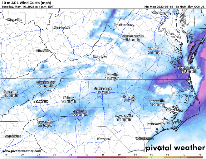
Wind Map Courtesy of Pivotalweather.com

STP Courtesy of Weathermodels.com
Severe Prediction Center Has Issued A Slight Risk
From Asheville to Boone and all around WNC tomorrow afternoon will be a dangerous afternoon for weather. Below you can see that all across the State there will la chance for severe weather. I will do my best to post updates but have several sources of media to get your reports! Check back soon for a YouTube update!


