

Threat Increasing For Accumulating Snowfall Late Sunday Night/Early Monday Morning
Models continue to struggle with the approaching frontal passage, but a common theme among models is the first chance at accumulating snowfall for many in WNC. Below is my initial projected snowfall map for this event. I will likely tweak this again before tomorrow night, but these are my thoughts on accumulation through early Monday morning around WNC.

Contact my local trusted roofing source Matt at RedWolf Contracting Services to take care of all of your roof replacements. From shingles, to metal roofing, and even commercial rubber membrane, Matt has the resources and solutions to take care of your job in a professional and cost effective manner. Call (828) 772-9778 or visit nc-roofers.com to set up your free roof inspection.
Model Discussion
At this point in time meteorologist begin to switch their focus from models like the GFS and European model to short range models like the NAM, HRRR, & RGEM. Only 36 away from this event, we should be getting some consensus at least among models like the GFS and Euro, but that is not happening. That is do to the extreme dynamics that are going to come into play with this storm. With 4-5 things that will be key to produce this snowstorm across WNC, it will be difficult to nail down actual projected totals until I see what the storm looks like on radar tomorrow. Nonetheless lets look at the most recent short range models, as well as what the GFS and European models are showing.
12z NAM
12z NAM Courtesy of Pivotalweather.com
The trusted local accounting firm for WNC, let the team of Adrianne & Caroyl take care of all of your tax needs. Whether you need payroll/business accounting help or assistance filing your personal taxes, these ladies are the experts to put your trust with. Give them a call (828) 684-7374 or visit their website http://www.kruseaccounting.com to set up your appointment today!
12z NAM-3km

3km NAM Courtesy of Pivotalweather.com
12z HRRR
12z HRRR Courtesy of Pivotalweather.com
Ground Temps A Concern For Accumulation
Heavy rate of snowfall will overcome very warm ground temperatures in many situations. I believe that is why the models still show accumulation with this system, even though the ground has been so warm. If the snow can create a slushy layer on top of the ground, then it starts to insulate itself as accumulation occurs. As soon as the accumulation stops, melting takes over. With temperatures not expected to get out of the 30’s on Monday, melt will be occurring but temperatures won’t rebound a quickly as we would like. Roadway issues could be a problem on Monday am, especially above 3000’. Depending on how strong the system gets, roadways could become an issue even in some valley locations. Still a lot of information to be detailed out. Below is one more short range model (RGEM) & then the most recent GFS & European model runs.
12z RDPS
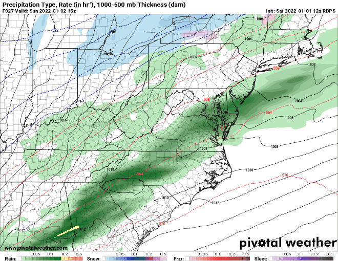
RDPS Courtesy of Pivotalweather.com
12z GFS
GFS Courtesy of Pivotalweather.com
6z European
6z European Model Courtesy of Pivotalweather.com
Conclusion
More info is need and I will produce another snowfall map tomorrow before the storm. Look for that and look for another YouTube video tomorrow detailing out the radar trends.


