
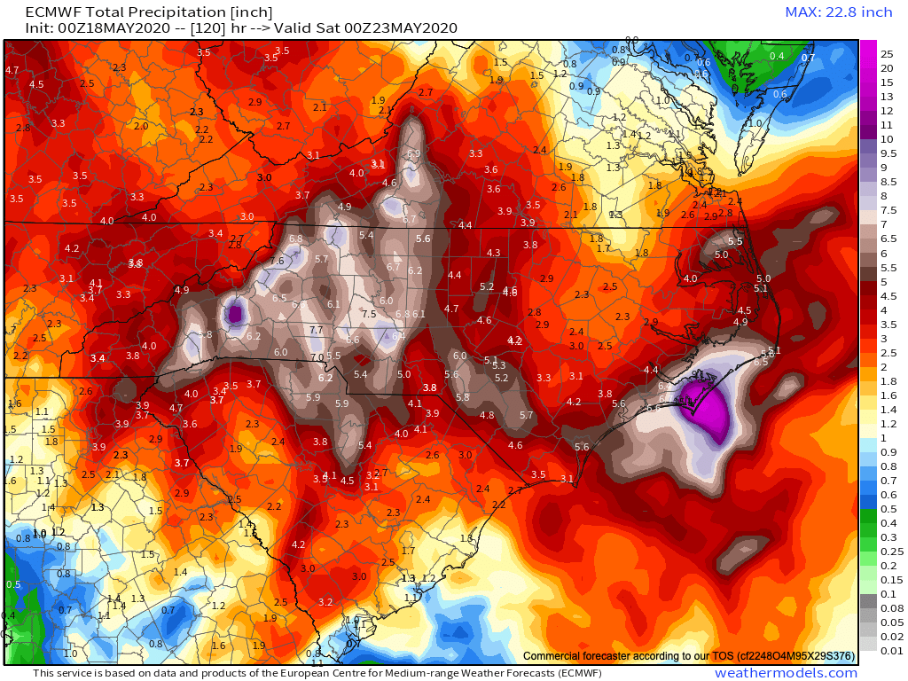
I hope that you enjoyed your small dry spell, because those days have now passed and the deluge of rainfall will continue around WNC. Most models indicated that around 5” of rainfall or even more will fall across the majority WNC by the end of the day on Friday, with some isolated locations seeing 10”+ of rain. Below you can see the most recent European model precipitation forecast and what how much precipitation it is projecting through Friday afternoon.
Euro Precipitation Forecast Courtesy of Weathermodels.com

Call the team that keeps my truck clean at A&R Specialist! David, Matt & Harley run A&R Specialist at 621 Brevard Rd. and they are the guys to trust with your vehicle cleaning & detailing. Whether you need a deep wax every once in a while or a quality clean and detail, you can feel safe putting your car in the hands of A&R Specialist! Call (828) 708-3718 to set up your appointment today. https://www.facebook.com/ARpressurewashing4/
Yes, that is just one model.. but it has been showing this amount of precipitation constantly for the past several runs, and now the GFS model has began showing similar total. If you joined me live last night, that was the one caveat in my forecast as to why I was apprehensive to call for extremely significant rainfall for all of WNC. As you can see below the GFS is now indicating that those 2”+ totals will even be possible down towards locations like Franklin & Murphy, NC. So with that being said, flash flooding will be likely all across WNC.
GFS Precipitation Totals Through Friday AM Courtesy of Weathermodels.com

Contact my local trusted roofing source Matt at RedWolf Contracting Services to take care of all of your roof replacements. From shingles, to metal roofing, and even commercial rubber membrane, Matt has the resources and solutions to take care of your job in a professional and cost effective manner. Call (828) 772-9778 or visit nc-roofers.com to set up your free roof inspection.
Flash Flooding, Mudslides Likely Along Blue Ridge Escarpment
These significantly high rainfall total will cause several problems around WNC including mudslides. Slopes around the area will struggle to handle round after round of heavy deluges and eventually isolated slopes will give way. Of course it is uncertain where exactly those slope failures will occur, but with this amount of rainfall projected, it appear imminent that it will occur. Streams & rivers will also rise quickly across WNC when heavy rainfall moves in periodically over the next 5 days, and if water begins to threaten your home you need to move to higher ground. Ponding on the roadways is all but certain over the next 5 days so please use caution if you are out and about traveling around WNC, roadways could turn dangerous. Below you can see what the short range Nam 3km projects regarding precipitation through mid day on Wednesday. The areas I am most concerned about are located along the Blue Ridge Escarpment. If you reside in the circled locations, please know that your location is at a higher risk for significant rainfall and flooding.
Nam 3km Precipitation Totals Courtesy of Weathermodels.com

For the finest landscaping in Western North Carolina, contact Sam Byrnside of L & S Landscape for a free estimate. From planting to mowing, mulching and all landscaping necessities in between contact Sam & his team! L & S also does salting of roads & driveways during the winter as well as tow pull outs if you get stuck in bad weather! Just give Sam a call (828)329-6020 to schedule your appointment today! Visit Site
Timing
Well if you look out your window, most of you will find that it is already raining or has rained at your home in WNC… and that looks to be the theme through Friday. Showers & storms will be periodic over the next several days, and nailing down exactly when it will and won’t rain at your house will be a matter of evaluating the radar in real time. You can find the official AshevilleWX Radar here. Below you can see a depiction of how the situation could possible unfold per the Nam 3km. This is just a simulated radar, but will give you an idea of the round after round idea of rainfall that I am expecting.
Nam 3km Simulated Radar Through Early Wednesday Afternoon Courtesy of Weathermodels.com

Currently closed due to Cover-19 Hot Springs Resort & Spa looks forward to welcoming you back ASAP.. Come to where Mother Nature waved her magic wand and created one of the most natural of all wonders, Natural Hot Mineral Waters. Heated deep within the earth, these crystal clear carbonated waters are are world famous for their mineral content and legendary healing powers. We pipe these waters to modern outdoor jetted hot tubs that we rent privately by the hour. In addition to our World Famous Natural Hot Mineral baths the day spa offers massage, body treatments, and skin care options. Hot Springs Resort also offers accommodations and camping options. Please visit http://www.nchotsprings.com for more information.
What Is Causing This Prolonged Rainfall?
A strong Upper Level Low pressure will move over the mountains of WNC and basically stall out as it pushes Tropical Storm Arthur out to sea. This strong cold pool of air aloft will create excessive lift and massive amounts of precipitation will be squeezed out of a saturated airmass. Below you can watch the upper air maps and notice how that low just spins over WNC for several days. These spokes of vorticity will spin up storm after storm for the area, with 7”+ of rainfall likely falling somewhere by Friday.
Upper Air Map Courtesy of Tropicaltidbits.com
Mild Pattern Setting Up
Temperatures on Wednesday morning will feel chilly as the Upper Level Low allows them to drop into the upper 40’s around WNC. This pattern will take hold over the next 10 days, and high temperatures will struggle to reach 80 each day. This is unseasonably cold for this time of the year, and could put this May in the top 10 coolest on record for our area. That remains to be seen though. What I do know currently is that we have to push through these next 5 days of nasty rainfall, but there is some light at the end of the tunnel. Check back soon for more information!
ECMWF 10 Day Courtesy of Weathermodels.com


