
Two intriguing storms will move through WNC early this week, and each system will have its own unique effects. The first low pressure will bring heavy rainfall to most of the area. I am expecting a widespread 1”-2” of rainfall, and some high elevation locations above 4500’ could see some mixing with snow. Then my focus will turn to the Tuesday night/Wednesday event, which appears to have the capacity to affect a much greater portion of WNC with wintry weather. The form of precipitation that will fall is still very much up in the air for Wednesday, but many models are beginning to show an icy solution. First let’s discuss this initial push of moisture, and how much rainfall you can expect for your area.
Model Rainfall Totals For Monday
Below you can see the most recent GFS and how much rainfall it depicts from this first frontal passage. Some flash flooding will be possible as close to 2” of rainfall falls around the Asheville area.
GFS Total Precipitation Through Monday Evening Courtesy of Weathermodels.com

Contact my local trusted roofing source Matt at RedWolf Contracting Services to take care of all of your roof replacements. From shingles, to metal roofing, and even commercial rubber membrane, Matt has the resources and solutions to take care of your job in a professional and cost effective manner. Call (828) 772-9778 or visit nc-roofers.com to set up your free roof inspection.
Now let’s compare that GFS with the European model output below. As you can there is good agreement that over 1.5” of rain will fall across most of WNC. Flash flooding will be possible in isolated locations, and ponding on the roadways could be a problem on the morning commute Monday.
Euro Precipitation Totals Courtesy of Weathermodels.com
We're here to help reduce the use of single-use plastics by offering bulk refills of household needs. Come refill your empty containers (shampoo bottles, hand soap dispensers, laundry detergent containers, jars etc) with our more natural products and pay by the ounce! To The Brim Click Here
Wintry Mix Possible Late Tuesday & Early Wednesday
Models continue to focus on a second wave that will move through WNC late Tuesday or Early Wednesday that will take advantage of an exiting cold front to our North. As a shallow layer of cold air sets up at the surface, ice could develop across WNC & The Blue Ridge Escarpment as the day progresses on through Wednesday. Below you can see the most recent European Model, and how it plays out the two systems over the next 5 days.
Euro Courtesy of Pivotalweather.com

Come to where Mother Nature waved her magic wand and created one of the most natural of all wonders, Natural Hot Mineral Waters. Heated deep within the earth, these crystal clear carbonated waters are are world famous for their mineral content and legendary healing powers. We pipe these waters to modern outdoor jetted hot tubs that we rent privately by the hour. In addition to our World Famous Natural Hot Mineral baths the day spa offers massage, body treatments, and skin care options. Hot Springs Resort also offers accommodations and camping options. Please visit http://www.nchotsprings.com for more information.
GFS Comparison
There are several similarities among the most recent GFS (6z) and the most recent European (0z) runs. They both build in a very strong high pressure after the first storm exits. Thus allowing for a shallow layer of cold air to entrench itself at the surface. These type systems are considered Miller B type systems. Typically somewhere in the Piedmont of NC always sees ice from this type of setup. Depending on how strong the High pressure is will determine how far that cold air gets into WNC. The closer you live to The Blue Ridge Escarpment, the better chance you have for seeing accumulating ice Tuesday night and into Wednesday. Below you can see what the most recent GFS shows.
GFS Precipitation Depiction Courtesy of Pivotalweather.com

Call the team that keeps my truck clean at A&R Specialist! David, Matt & Harley run A&R Specialist at 621 Brevard Rd. and they are the guys to trust with your vehicle cleaning & detailing. Whether you need a deep wax every once in a while or a quality clean and detail, you can feel safe putting your car in the hands of A&R Specialist! Call (828) 708-3718 to set up your appointment today. https://www.facebook.com/ARpressurewashing4/
Ice, Ice, Baby
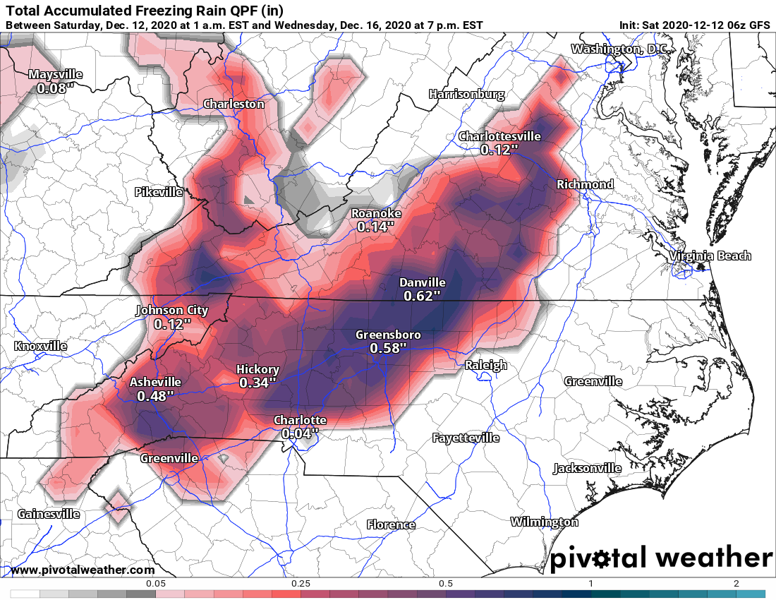
The chances for ice have significantly increased over the past few days for the Tuesday night-Wednesday time frame. Depending on how strong the high pressure to our north is will determine how far into the valleys the cold air infiltrates. Below you can see the most recent GFS and what it showed regarding freezing rain/ice accumulation. This should be taken with a grain of salt, but it gives you an idea of what the models are spitting out currently regarding totals. Some snow could mix in with this ice at the beginning, but we still have soo many detail to nail down. Check back soon for another update, i’ll have a couple of live updates coming your way this week!
GFS Freezing Rain Map Courtesy of Pivotalweather.com


