
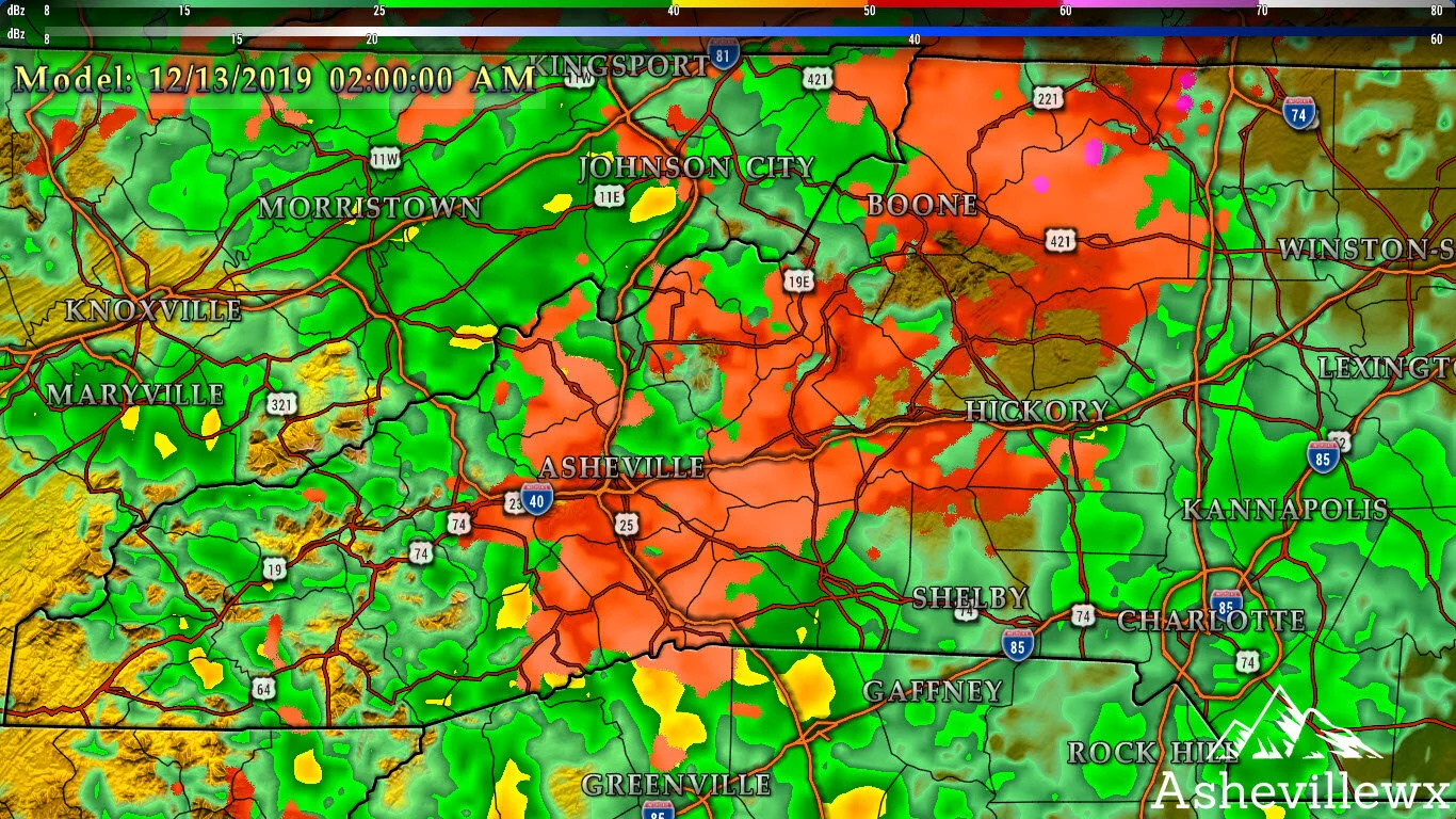
Models are continuing to form a consensus on where exactly the freezing temperatures set up, but it does appear that many locations along the Blue Ridge Escarpment including Hendersonville will see frozen precipitation falling late tonight & tomorrow AM. Other locations will remain as rain where surface temperatures push above freezing. There are Winter Weather Advisories out for all Blue Ridge Escarpment locations with up to .1” of ice accretion possible. That doesn’t seem like much, but it doesn’t take a lot of freezing rain to create very slick roadways. Below you can see the most recent Nam 3km model precipitation depiction at 2am early tomorrow morning. As you can see, the 3km believes that even a good portion of the French Broad River Valley will see some form of freezing precipitation fall for a short duration.

Come to where Mother Nature waved her magic wand and created one of the most natural of all wonders, Natural Hot Mineral Waters. Heated deep within the earth, these crystal clear carbonated waters are are world famous for their mineral content and legendary healing powers. We pipe these waters to modern outdoor jetted hot tubs that we rent privately by the hour. In addition to our World Famous Natural Hot Mineral baths the day spa offers massage, body treatments, and skin care options. Hot Springs Resort also offers accommodations and camping options. Please visit http://www.nchotsprings.com for more information.
We are not talking about a crippling ice storm here, but a glazing that could potential create an ice coating on elevated surfaces. Some accretion on roadways cannot be ruled out, and the closer you are to the Blue Ridge Escarpment.. the better the chances are for roadways to become icy. Temperatures will hover right around 30 degrees when the precipitation begins to move in, and isolated pockets of upper 20’s are where problems could really occur. Below are the Nam 3km projected temperatures at 2am as the main precipitation moves in.
Above you can see that temperatures around Hendersonville and Brevard are expected to be cooler compared to temperatures around Asheville. As you head to the SW of Asheville, temperatures jump almost 10 degrees. That is due to Cold Air Damming, or CAD. As a strong arctic high begins to retreat out into the Atlantic, the cold air that it moved in tries to hang on. When precipitation moves in, the cold air is still in place and creates icy conditions for the surface below.
3km Nam Depiction Courtesy of Weathermodels.com

Call the team that keeps my truck clean at A&R Specialist! David, Matt & Harley run A&R Specialist at 621 Brevard Rd. and they are the guys to trust with your vehicle cleaning & detailing. Whether you need a deep wax every once in a while or a quality clean and detail, you can feel safe putting your car in the hands of A&R Specialist! Call (828) 708-3718 to set up your appointment today. https://www.facebook.com/ARpressurewashing4/
That surface high will retreat as the moisture continues to move in through Friday evening, and temperatures will eventually rise above freezing for all locations around WNC.. but the cold air could be a bit more stubborn than what models show.
1” of Rainfall Expected Through Saturday
Over an inch of rainfall could be in store for WNC through Saturday as the Gulf Low pushes through the area. Some isolated flash flooding and ponding on roadways is to be expected, but nothing significant. This rain will however ruin any plans made for Saturday outside during the day. Unfortunately it doesn’t appear to let up until late Saturday night or early Sunday morning, and some locations could even switch over to snow showers as the precipitation exits.

Contact my local trusted roofing source Matt at RedWolf Contracting Services to take care of all of your roof replacements. From shingles, to metal roofing, and even commercial rubber membrane, Matt has the resources and solutions to take care of your job in a professional and cost effective manner. Call (828) 772-9778 or visit nc-roofers.com to set up your free roof inspection.
Snow Showers Cant Be Ruled Out Early Sunday AM
An elongated 500mb trough will set up over the mountains of WNC as the low pressure moves off the coast. This will create precipitation in Eastern TN, and that will move over the mountains of WNC eventually. High elevation locations above 3500’ should certainly see some form of snowfall form this, but I could also see some valley locations seeing snowflakes again. This feature will need to be resolved by models in more depth, but several models have been showing the potential for at least high elevation snow as the system exits. I will keep you updated on that threat as well so check back later for more information!


