Asheville

AshevilleWX 2020-2021 Winter Weather Outlook

AshevilleWX 2020-2021 Winter Weather Outlook

Each year here at AshevilleWX we do our best to put out a reasonable forecast about what you can expect during winter, based off of several factors. Most of this forecast is rooted in historical data and conclusions are reached through data comparison. Once we denote similarities of how a particular year is setting up, we can compare this data to data from years past to create a Winter Weather Outlook. This is merely a long range forecast though, and there is great uncertainty as usually with exactly how winter will unfold here in the mountains of WNC. Below you can find my 2020-2021 Winter Weather Outlook.

Graphic Produced By Evan Fisher

Seasonal Snowfall 20’-21’ Projections

Boone: 28”-35”

Asheville: 6”-8”

Charlotte: 2”-3”

Greensboro: 4”-6”

Raleigh: 3”-5”

Wilmington: 1”-2”

Come to where Mother Nature waved her magic wand and created one of the most natural of all wonders, Natural Hot Mineral Waters. Heated deep within the earth, these crystal clear carbonated waters are are world famous for their mineral content and l…

Come to where Mother Nature waved her magic wand and created one of the most natural of all wonders, Natural Hot Mineral Waters. Heated deep within the earth, these crystal clear carbonated waters are are world famous for their mineral content and legendary healing powers. We pipe these waters to modern outdoor jetted hot tubs that we rent privately by the hour. In addition to our World Famous Natural Hot Mineral baths the day spa offers massage, body treatments, and skin care options. Hot Springs Resort also offers accommodations and camping options. Please visit http://www.nchotsprings.com for more information.

Why Less Than Average Snowfall For WNC?

There are a couple of factors that have lead me to forecast less than average snowfall for WNC this year, but the main reason is due to a moderate to strong La Nina setting up. What is La Nina? This is when cooling happens in the Nino region of the Pacific Ocean. The Nino region is observed on a regular basis by multiple sensors that monitor water temperatures. This area is where weather is generated for portions of the United States. If this region is warmer than normal then El Nino is consider to be in place. If the region is cooler than normal then La Nina is considered to be occurring. Historically, we see wetter conditions during El Nino events here in WNC. This means that warmer than normal temperatures in the Nino 3.4 region equates to wetter winter conditions in the Mountains of WNC. On the other hand, a La Nina would mean that temperatures in the Nino 3.4 region of the Pacific Ocean are cooler compared to the average. Historically during La Nina years, less precipitation has moved through WNC during winter time frames. With less activity in the key region, storms and Gulf Lows will be limited around the South. Strong cold shots are also possible with La Nina season, but I am leaning more towards a mild winter compared to a bitter cold one. That still remains to be seen though.

Moderate To Strong La Nina Setting Up

We have a moderate to strong La Nina setting up in the key Nino region where observations are taken. That means that cold water is pooling up in this region, and sea surface temperatures are falling below average. Therefore, limited storm development is expected to occur along the Equator and that means less precipitation moving through the Southeast. This is strictly based off of historical data. Below you can see what a typical La Nina looks like when observing sea surface temperatures.

Call the team that keeps my truck clean at A&R Specialist! David, Matt & Harley run A&R Specialist at 621 Brevard Rd. and they are the guys to trust with your vehicle cleaning & detailing. Whether you need a deep wax every once in a …

Call the team that keeps my truck clean at A&R Specialist! David, Matt & Harley run A&R Specialist at 621 Brevard Rd. and they are the guys to trust with your vehicle cleaning & detailing. Whether you need a deep wax every once in a while or a quality clean and detail, you can feel safe putting your car in the hands of A&R Specialist! Call (828) 708-3718 to set up your appointment today. https://www.facebook.com/ARpressurewashing4/

What To Expect Here In WNC?

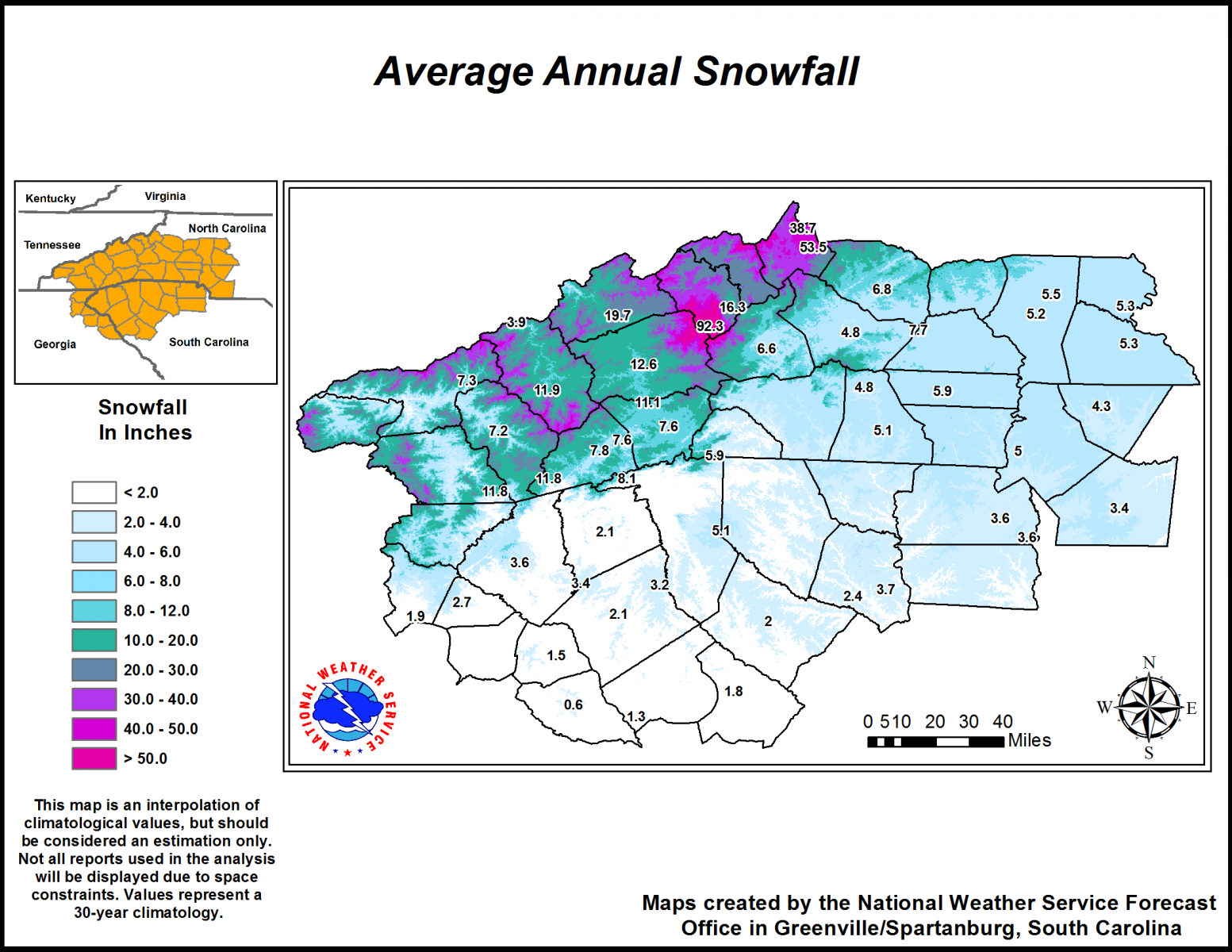
Evan Fisher has produced a great graphic that details out the amount of snowfall we received here in WNC each Moderate or Strong La Nina year. As you can see below, there is great variation among average snowfall each year during moderate & Strong La Nina years.

Map Produced By Evan Fisher

Here is also a map that shows the combined average of snowfall each year during Moderate & Strong La Nina Winters. As you can see, we are working with limit data to compare with only 11 data points of comparison. Moderate to Strong La Ninas are somewhat rare, which is why there is great uncertainty with this forecast.

Map Produced By Evan Fisher

Contact my local trusted roofing source Matt at RedWolf Contracting Services to take care of all of your roof replacements. From shingles, to metal roofing, and even commercial rubber membrane, Matt has the resources and solutions to take care of yo…

Contact my local trusted roofing source Matt at RedWolf Contracting Services to take care of all of your roof replacements. From shingles, to metal roofing, and even commercial rubber membrane, Matt has the resources and solutions to take care of your job in a professional and cost effective manner. Call (828) 772-9778 or visit nc-roofers.com to set up your free roof inspection.

Forecast

I posted this map above, but it is worth revisiting. I believe that Northwest Flow Snowfall will dominate totals this year in the NC Mountains, with close to average yearly snowfall totals being possible. Throughout the years, Northwest Flow has been the most consistent with providing snow events to the border counties.. and during this La Nina event I believe that sweeping arctic fronts this winter will bring several chances for Northwest Flow. That is why I have place most elevations above 3500’ in WNC at 80%-100% of normal in my projection map. Moving into the valley areas of WNC where snowfall totals are typically achieved by strong Gulf Low pressures, I have placed 60%-80% of normal snowfall. With limited storms moving in from the Gulf region, I think chances will be limited for a large snowstorm across the Southeast. That of course does not mean that one is not possible, history just shows that WNC and NC in general receive less precipitation during La Nina years.

We're here to help reduce the use of single-use plastics by offering bulk refills of household needs. Come refill your empty containers (shampoo bottles, hand soap dispensers, laundry detergent containers, jars etc) with our more natural products an…

We're here to help reduce the use of single-use plastics by offering bulk refills of household needs. Come refill your empty containers (shampoo bottles, hand soap dispensers, laundry detergent containers, jars etc) with our more natural products and pay by the ounce! www.facebook.com/tothebrimrefill

Moving on to the Piedmont area, I am projecting 60%-80% of average snowfall for the areas like Greensboro & Charlotte. Each year these locations tend to receive their yearly snowfall totals from Gulf Lows, and I am of the opinion that those will be limited this year. Things like backdoor frontal passages will be where snowfall is picked up in the Piedmont, but the chances for Gulf Lows appear to be less compared to El Nino years.

The Raleigh area will be an area of transition in my opinion. I believe that we will see a strong cold shot or two this year, and this will be where locations along the Coast of NC see their chance for snow. During La Nina seasons, suppression of storms can lead to strong cold meeting with a meandering low pressure along the coast. It is my opinion that we will see one of these type storms develop this winter, and locations along the coast will receive 100%-120% normal snowfall. The Raleigh area, being on the fringe of these events, as well benefiting from backdoor cold fronts and placing that location in my 80%-100% yearly snow average zone.

Model Data

I have sourced a couple of long range models as well to illustrate the outlook on snowfall for this winter. Snow lovers will not like these maps, but they are a good indicator and were somewhat accurate last year when I made my forecast for below normal snowfall for the Asheville area. These maps were all provided by https://www.bennollweather.com.

Model Super Blend

European Model Snowfall Forecast By Month

UKMET Snowfall Forecast By Month

Conclusion

This year across WNC, snowfall averages will vary greatly. Based off of a super blend of knowledge, I forecast that WNC will see slightly below normal snowfall, with near average temperatures throughout the season. Conditions could be fairly dry at times with limited forcing from the Pacific, but one Gulf Low that threads the needle will be all it takes to bust my forecast. Please take this forecast with a grain of salt, and know that these forecast are mainly for fun and enjoyment. Know the winter weather is extremely unpredictable, and each year a new precedence can be set. Use this article for fun, but don’t use it as spoken word because no winter forecast should be taken as certainty.

-Meteorologist Hunter Ward

2019-2020 AshevilleWX Winter Weather Forecast-Volatile Winter Ahead

Volatile Winter Ahead With Average Precipitation & Large Temperature Swings In Store For WNC

Each year I try and put together a general idea of how I think winter could play out around WNC based off of history, and the use of long range forecast methods. This includes the observation of the state of Sea Surface Temperatures (SST), the QBO (stratospheric winds), Solar Max/Mins, ENSO (El Nino/La Nina), and other various atmospheric anomalies that play into the complicated equation of winter weather in the Southeast. These methods are not exact, and many variables must be accounted for.. therefore accuracy from time to time is limited, especially here in the mountains of WNC. So without further ado, below is my 2019-2020 Winter Forecast for NC.

AshevilleWX 2019-2020 Winter Forecast

Come to where Mother Nature waved her magic wand and created one of the most natural of all wonders, Natural Hot Mineral Waters. Heated deep within the earth, these crystal clear carbonated waters are are world famous for their mineral content and l…

Come to where Mother Nature waved her magic wand and created one of the most natural of all wonders, Natural Hot Mineral Waters. Heated deep within the earth, these crystal clear carbonated waters are are world famous for their mineral content and legendary healing powers. We pipe these waters to modern outdoor jetted hot tubs that we rent privately by the hour. In addition to our World Famous Natural Hot Mineral baths the day spa offers massage, body treatments, and skin care options. Hot Springs Resort also offers accommodations and camping options. Please visit http://www.nchotsprings.com for more information.

Large Temperature Swings Expected This Winter

For Western North Carolina this winter, I am expecting average to above average snowfall in locations above 3500’, and slightly below average to average snowfall for locations below 3500’. I am basing this off of the belief that Northwest Flow snow will be more often this year compared to some other previous years, and that we will receive one or two moderate to large snowfall that will satisfy averages around the area. Below is the average annual snowfall for WNC per the NWS in GSP. If you extrapolate my percentages, you will determine that I expect around 10”-11” of snow total for Asheville this year. That would not be a blockbuster winter, but would fall in line with the average over the past 30 years.

Courtesy of GSP NWS

Here is the average seasonal snowfall for the entire state of North Carolina per the National Weather Service. As I stated earlier, I expect one or two big storm for the Southeast, and that will likely satisfy or come close to satisfying many averages. It doesn’t take much for some locations! With a near natural ENSO (El Nino/LaNina Index), we will likely enter into what is considered a Modoki El Nino, which is rare. Only a few years previously have been Modoki El Nino years so we have very little to compare to.

Modoki El Nino

So what exactly is a Modoki El Nino or even El Nino? When long range forecasting, meteorologist will observe the sea surface temperatures anomalies (SST) in a particular region of the Pacific Ocean know as Nino 3.4 region. Depending on where the water is cooling and warming at, plays a huge part in where systems develop in winter, as well as the direction they move. The United States weather moves in from the Pacific Ocean, so where storms develop, and which path they take towards the US matters greatly. Below is a graph showing what a strong El Nino would look like in the Nino 3.4 region taken from the year 2015.

Call the team that keeps my truck clean at A&R Specialist! David, Matt & Harley run A&R Specialist at 621 Brevard Rd. and they are the guys to trust with your vehicle cleaning & detailing. Whether you need a deep wax every once in a …

Call the team that keeps my truck clean at A&R Specialist! David, Matt & Harley run A&R Specialist at 621 Brevard Rd. and they are the guys to trust with your vehicle cleaning & detailing. Whether you need a deep wax every once in a while or a quality clean and detail, you can feel safe putting your car in the hands of A&R Specialist! Call (828) 708-3718 to set up your appointment today. https://www.facebook.com/ARpressurewashing4/

La Nina on the other hand is a cooling of the 3.4 Nino region. You can see what that looks like on the graph below from the winter of 2010-2011.

La NinaGraphic.jpg

Currently the ENSO region is showing a near natural signal, and many experts believe that it will either stay neutral or move slightly positive through the winter. A modoki El Nino is a near netural El Nino where a large basis of the warm water is positioned in the eastern portion of the Nino 3.4 region. You can see below the current sea surface temps and in the Nino 3.4 region there is only slight warming. At the end though, notice how it is extending to the East. That is a sign that a Modoki El Nino could be on the horizon.

Source: CPC

Modoki El Nino History In WNC

Years of Occurrence:

Winter (Nov-Mar)1991-1992 Asheville Snowfall: 1.5” Asheville Total Precipitation: 18.46”

Winter (Nov-Mar)1994-1995 Asheville Snowfall: 3.4” Asheville Total Precipitation: 18.56”

Winter (Nov-Mar)2002-2003 Asheville Snowfall: 17.9” Asheville Total Precipitation: 20.63”

Winter (Nov-Mar)2004-2005 Asheville Snowfall: 6.6” Asheville Total Precipitation: 16.35”

Winter (Nov-Mar)2009-2010 Asheville Snowfall: 39.2” Asheville Total Precipitation: 28.95”


These are the only years that an east based natural Nino (Modoki El Nino) has been present. As you can see, it’s a relatively new phenomenon. With that east based warmth, comes ample amounts of moisture that move into the Southeast. So, based off the numbers provided, one can assume that if the temperatures in Nino Region 3.4 stay consistent.. 15”+ of precipitation around WNC will be likely this winter. But will the cold air be in place for snow? That is the question, and we will need to look more at the winters of 2002-2003 & 2009-2010. I will observe the winter of 1991-1992 more closely because we were also in a drought at this point in time during 1991. With 1.27” in September of 1991, & only .19” of rain in October of 1991, WNC was in a deeper drought compared to where we currently sit.. but there are comparisons to be made.


Temperature Data Leading Into Modoki Years For WNC

Average September Temperature For Asheville:

1991: 67.2 degrees

1994: 64.6 degrees

2002: 68.8 degrees

2004: 66.4 degrees

2009: 66.9 degrees

2019: 71.2 degrees

So this tells us that we are leading into a neutral east base El Nino as we come off of our warmest September of all comparison dates. I think that trend continues too, and that a several warm shots will be possible this winter. That doesn’t mean that there will not be cold, but as I stated earlier, I believe large temperature swings will be likely. There is some long range model data to also support this warm idea. Below you can see the European Model monthly temperature anomalies, and each period shows above average temperatures for the Southeast.

NOV/DEC/JAN Courtesy of Weathermodels.com

Contact my local trusted roofing source Matt at RedWolf Contracting Services to take care of all of your roof replacements. From shingles, to metal roofing, and even commercial rubber membrane, Matt has the resources and solutions to take care of yo…

Contact my local trusted roofing source Matt at RedWolf Contracting Services to take care of all of your roof replacements. From shingles, to metal roofing, and even commercial rubber membrane, Matt has the resources and solutions to take care of your job in a professional and cost effective manner. Call (828) 772-9778 or visit nc-roofers.com to set up your free roof inspection.

DEC/JAN/FEB Courtesy of Weathermodels.com

JAN/FEB/MAR Courtesy of Weathermodels.com

Will It Actually Be As Warm As The Models Show?

A word of caution with the Euro monthly charts, they are great guidance.. but on average last winter they were only right about 20% of the time. That being said, there does appear to be an increasing likelihood that this winter will be above average temperature-wise. So, a smart/easy bet for a winter forecast would be to go with warm and wet… but there is a wildcard this year.

Solar Minimum=Wildcard

We are progressing deeper into a solar minimum, which mean that solar flare activity is trending down. With less sun spots (none in the last 200+ days) this is the least active the sun has been since 2009. Remember the winter of 2009-2010? Almost 40” of snow fell that year at the Asheville Airport. Here’s an excerpt from Whats Up With That regarding how low solar activity correlates to shots of cold.

Low solar activity has been well correlated with an atmospheric phenomenon known as “high-latitude blocking” and this could play an important role in the upcoming winter season; especially, across the eastern US. In addition, one of the natural impacts of decreasing solar activity is the weakening of the ambient solar wind and its magnetic field which, in turn, allows more cosmic rays to penetrate the solar system. The intensification of cosmic rays can have important consequences on such things as Earth’s cloud cover and climate, the safety of air travelers, and as a possible trigger mechanism for lightning.

From Whats Up With That

High-latitude blocking is the key to getting cold air down to the Southeast. When you hear me talk about indices like the NAO & the AO, these are all measures of the degree of high latitude blocking in place. The blocking effectively creates a wall that deflects cold air from the arctic, down into the United States. How strong this blocking is, and where exactly it comes from, will determine how cold it gets in the Southeast.. and across the rest of the East Coast.

So we are entering a period of solar minimum that could rival any other period in the last 100 years. Does that mean record cold is possible? Maybe, but it really just tells me that this will be a unique winter, with several variable that will need to be properly accounted for.

QBO (Quasi-Binary Oscillation)

The last bit of information I will discuss before my conclusion is the QBO. This is a daily observation of stratospheric winds along the equatorial area. Detected over 50 years ago, these winds are measure by radio signal at various points in the atmosphere. By tabulating this data over the past 50 years in an increasingly large area, we have been able to tie certain atmospherical outcomes to either a positive or negative QBO. What you need to know here is that a negative QBO is known to correlate with high-latitude blocking. As you learned a few minutes ago, high latitude blocking sends cold air down into the United States. If a negative QBO stays persistent as projected by many, then cold shots this year will be likely.

Conclusion

So I know that I have detailed out a lot of information, but what you really need to know is that I believe that an East based Modoki El Nino will provide ample moisture that moves through the Southeast. At some point in time this winter, the high-latitude blocking will get in place, and put enough cold air into WNC and other portions of NC as moisture moves in from the Southeast, and in turn snow will fall. How often that happens is of course an unknown, but there are signs that indicate that the players will be on the field for a snowstorm this winter. We will see exactly how the Solar Minimum plays in because many experts are calling for a very warm winter. If we end up cold, or below normal temperature-wise, the Solar Minimum will have to be taken seriously. So again, I expect 1-2 large storms that will put many locations across NC at or close to their average yearly snowfall. Temperature swings will be frequent, and record daily highs/ lows both cannot be ruled out. It will be volatile. With this volatility I believe will come the possibility of frequent Northwest Flow Snow for the higher elevations of WNC. This will push those areas above their normal yearly averages. Asheville should expect around average snowfall, and as you progress east, the chances for a significant snow decreases. This is my best guess, and is only a forecast. These forecast can easily be busted or made by 1 storm, so please stay tuned for my daily forecast to keep yourself up to date on the approaching weather!

-Meteorologist Hunter Ward

Storm Development Likely This Afternoon Around WNC

Models indicate that storm development is likely this afternoon in WNC.  These storms look to be slow moving and could drop over an inch of rainfall in insolated locations.  I do not expect them to go severe though, meaning hail is not likely.  Temperatures will max out in the low 80’s, and I am forecasting 82 degrees for the Asheville airport.

When? 

Storm development looks to initiate around 2pm-3pm, and these will persist through the evening.  Some locations may not see any rainfall from these isolated showers, but others could receive over 1”.  I do not expect extensive flooding from these storms, but pounding on the roadways cannot be ruled out.

IMG_5660.PNG

Above you can see the the HRRR radar depiction around 5pm this evening.  Storms look more likely north of Asheville, compared  to south.  Heavier rain and train storms look likely in Madison and Northen Buncome Co.  Please report any flooding that you see to Ashevillewx.

10 Weatherlore People Use To Predict Winter Weather

We’ve all heard Old-Timers with their cliche notions, touting tales of nature’s signs, and how their foreshadowing indicates the degree of difficulty for the winter months that will follow.  These tall tales though are plated with a note of science that keeps the winter lover savoring each year for a new bite.  Of the many stories or “weatherlore” that exists though, which ones hold the most scientific significance?  Below I will detail out the top 10 weatherlore that people in the South rely on, and then give some perspective into the scientific reasoning of why that notion is believed by some to be a valid predictor of winter.


10. Thick Deer Coat

Many people in the South believe that animals are an excellent predictor of weather to come, and they are not wrong in thinking so.  Animals are known to take nature’s signs and apply them to their daily life.  They can foretell of impeding natural disasters, and they use their heightened senses to prepare. Many animals have been documented in retreat from the coastline several minutes before a Tsunami arrives.  So what does this have to do with winter in the South?  

Deer are a prevalent species in the Southeast, and the hunting of them is also very popular.  Therefore, deer hunters are in contact with deer each year on a frequent basis.  From an online poll at Ashevillewx, I found that some people observe the thickness of the deers winter fur coat and how early it arrives to determine how severe winter will be. 

Science Behind: 

Deer, just like any other species, will prepare for winter in whatever way necessary.   They do not hibernate during the winter, but simply just move less.  Their metabolism actually slows to a crawl because food is scarce, and a thick coat is necessary to keep them warm.  If their coat is not thick enough for a harsh winter, they will likely die due to natural selection.  Therefore, thickness of a deers coat does have so scientific significance.  The problem though is that it is difficult to measure from year to year.  You can’t count the hairs, so one relies on the senses to measure this notion.  Therefore on a scale of 1-10, I give deer coats a 3 on the accuracy scale.


9. If It Thunders During Winter, It Will Snow In 7-10 Days 

CoweeMountainOverlookLightningnologo-1.jpg

During the winter months, some southerns believe that a crack of thunder indicates that it will snow in 7 days. Every time it thunders, comments flood in on Ashevillewx indicating the presences of thunder, and many locals begin a countdown. Why? Because of course their parents or grandparents taught them to do so. But why then did our grandparents believe these signs were significant? Because before weather models and the accumulation of data, they were!! Amy Graham-Silvers, an avid Ashevillewx reader states that her dad called them “old wives tales” and that he said “thunder in the winter means snow within the next 7-10 days”.

Science Behind:

Many times during winter, a strong high pressure will develop off the Southeast Atlantic Coast. This pushes warm air into the area, and most of the time eliminates the threat for snow. Precipitation that falls when this high pressure is strong, typically falls in the form of rain. In order to move this high away, it takes a strong front. A strong front would likely bring with it the chance for thunderstorm development. So the front pushes the high pressure out of the way, and cold air floods in behind after the thunder has occurred. So basically what I have just described is known as a pattern change. Strong fronts in the winter push away high pressures that are situated on the Southeast Atlantic Coast. Without a source of warm air, cooler air can dominate, and a Gulf Low with adequate positioning can create snowfall across the southeast. Therefore on a scale of 1/10, I give this Weatherlore a 5/10 regarding the accuracy of its predictions.

Contact my local trusted roofing source Matt at RedWolf Contracting Services to take care of all of your roof replacements. From shingles, to metal roofing, and even commercial rubber membrane, Matt has the resources and solutions to take care of yo…

Contact my local trusted roofing source Matt at RedWolf Contracting Services to take care of all of your roof replacements. From shingles, to metal roofing, and even commercial rubber membrane, Matt has the resources and solutions to take care of your job in a professional and cost effective manner. Call (828) 772-9778 or visit nc-roofers.com to set up your free roof inspection.

8. Cows Lying On The Ground Means It Will Snow

As a winter storm approaches, many Ashevillewx followers have observed cows laying on the ground around WNC. Do cows have a 6th sense that helps them prepare for the weather? Watson Geoffrey, an Ashevillewx reader said this.. “Some folks say when we get into the winter months, and one drives around the area (Burnsville, NC) or other. When one sees the cows all laying down, it going to snow that day or next day.” I delved into this a bit further to see if there was any science behind this theory.

Science Behind:

A study conducted by The University of Arizona found that cows like to stand up in warm weather, presumably so that they can disperse heat, and cool down quicker. Likewise, the University also concluded that when a front is approaches and weather is cooling down.. that cows will lie down. Another theory from the Farmers Almanac though says that cow lie down simple to chew their cud. So as far as reliability, I give this weatherlore a 2/10 regarding its usefulness in predicting snowfall.


7. Wasps Building Nests High

I had never heard this weatherlore before I proposed the question to my followers about what they look for, but a Johnathan Ray, a weather nerd like me from WNC states that “Wasps build their nests high and in protected areas avoiding low areas that may be overtook by snowy weather.” I ventured into this topic a bit more to analyze the scientific aspects and here what I found..

Screen Shot 2018-10-03 at 7.05.57 PM.png

Science Behind:

During heavy snowfall from winter storms, many areas will create drifts due to the direction of the wind. Most wasps die off during the winter months due to starvation (except for a few hearty queens). These queens will try and hibernate near the nest, and then reemerge when the temperatures reach around 50 degrees. So, one could infer that if a queen bee feels that winter will be extra cold, she will conduct her colony to build a nest higher, in order for her to stay safe. She must survive the winter in order for the offsprings to survive, so there could be some truth to this weatherlore, but I am skeptical. Regarding accuracy, I give it a 2/10.

6. Halo Around The Moon

Many Ashevillewx readers indicated that they looked for a halo around the moon as a weatherlore when a storm is approaching. This occurs many times throughout the year, so it doesn’t just refer to snow, but I will dive into the scientific details anyways to see if there is any truth to this tale.

Science Behind:

Cirrus clouds made of microscopic ice crystals high up in the upper atmosphere are what cause these halo’s around the moon to appear. Cirrus clouds can act independently, but many times they are associated with an approaching front. During the winter months, cooler temperatures are more prevalent in the atmosphere, so the existence of cirrus clouds increases. Propagated forward in extreme temperatures, these ice crystals foreshadow an abundance of moisture to follow. Thus, one can draw a vague association between halos around the moon, and approaching snowstorms. I give this method a 5/10.


5. Tight Corn Husks

As Fall approaches, farmers begin to gather their share of corn. Many old timers would look to how tight the corn husks were to determine how severe winter would be that year. Ashevillewx followers reminded me of this method and elaborated on it. Kim Crumpler states that “If corn shucks are very tight it’s a bad winter.” Johnathan Ray added that “Winter will be cold and snow if corn husks are thick and tight”. So lets enter into the science of why this theory might hold true.

Science Behind:

Corn husks will be high and tight in my experience to protect from rain in a very wet year. An extremely wet year would more then likely be preceded by a somewhat wet winter, that in many cases would produce snow. Thats about the only association that I can make between corn husks and winter weather, but I do know that many farmer used to use this weatherlore each year. As far as reliability, I would give this method a 3/10.

Call the team that keeps my truck clean at A&R Specialist! David, Matt & Harley run A&R Specialist at 621 Brevard Rd. and they are the guys to trust with your vehicle cleaning & detailing. Whether you need a deep wax every once in a …

Call the team that keeps my truck clean at A&R Specialist! David, Matt & Harley run A&R Specialist at 621 Brevard Rd. and they are the guys to trust with your vehicle cleaning & detailing. Whether you need a deep wax every once in a while or a quality clean and detail, you can feel safe putting your car in the hands of A&R Specialist! Call (828) 708-3718 to set up your appointment today. https://www.facebook.com/ARpressurewashing4/


4. Persimmon Seeds

Farmers have been cutting Persimmon seeds open for countless years to find out how severe winter that year would be. The old weatherlore says that if you find a spoon inside when cutting open the seed, expect plenty of snow to shovel, but if you find a fork shape, winter will be mild. Johnathan Ray, the area guru say “When persimmon seeds are split in half, they reveal either a spoon, knife, or fork shape. A knife indicates a winter that will be very cold, a spoon (which looks like a shovel!) predicts lots of snow, and a fork says winter will be mild.” So, lets see if there is actually some science behind this predictor.

Science Behind:

These depictions shown on the inside of the seed are actually roots. So do the roots grow more in an exceptionally wet year? I cannot find any studies to confirm anything on these, so my science really ends here unfortunately. The only thing I can really find is that if its a spoon you will be shoveling snow lol. So this weatherlore is very unknown as far as science.


3. Abundance Of Acorns

Around Western North Carolina we have many oak trees, and folks around the area over the years have become accustom to equating the acorn crop to how severe winter will be. A friend tells me that “Old timers used to believe that if the shell on the acorns extended lower on the nut itself then it would be a harsh winter. (BlueRidgeFolklore).” So, a large crop or acorns with shells that extended lower on the nut itself would indicate that a harsh winter was on the way. Is the tree anticipating that the squirrels will need to hibernate longer, therefore they will need more nuts? Or is it simply a wet year and the Oak tree is capable of producing more nuts. Lets look into the Science.

Science Behind

Oak trees will produce a larger crop of acorns during wet years. Like many of the other weatherlore, a wet year sometime precedes a harsh winter. So a likely correlation could be made.. but I have no science to back that up. Squirrels gathering nuts furiously could indicate that the squirrels sense a pressure drop, and are preparing for a storm. There is limited science to be found on this topic, but it seems to be one of the favorites.

Come to where Mother Nature waved her magic wand and created one of the most natural of all wonders, Natural Hot Mineral Waters. Heated deep within the earth, these crystal clear carbonated waters are are world famous for their mineral content and l…

Come to where Mother Nature waved her magic wand and created one of the most natural of all wonders, Natural Hot Mineral Waters. Heated deep within the earth, these crystal clear carbonated waters are are world famous for their mineral content and legendary healing powers. We pipe these waters to modern outdoor jetted hot tubs that we rent privately by the hour. In addition to our World Famous Natural Hot Mineral baths the day spa offers massage, body treatments, and skin care options. Hot Springs Resort also offers accommodations and camping options. Please visit http://www.nchotsprings.com for more information.

2. Wooly Bear Caterpillar

Many Ashevillewx readers chimed in about the use of the Wooly Bear Caterpillar, and the burnt orange band thats present on its coat. There is actually a festival held every year in Vermilion, Ohio where a local weatherman come and reads the wooly worms. How awesome is that? They also celebrate the Woolly Worm in Banner Elk, NC! So, if you believe this weatherlore, you are not alone! The story goes, that apparently however long the burnt orange stripe is, indicates how long winter will last. The dark bands in the stripe can also be used to signify when snows will occur. I love the concept, but it seems a little farfetched.. so lets see if there is any science behind the method.

Science Behind

Heres an except taken from weather.gov

“The woolly bear caterpillar's coloring is based on how long caterpillar has been feeding, its age, and species.  The better the growing season is the bigger it will grow.  This results in narrower red-orange bands in its middle.  Thus, the width of the banding is an indicator of the current or past season's growth rather than an indicator of the severity of the upcoming winter.  Also, the coloring indicates the age of the woolly bear caterpillar.”

As far as the story about the woolly caterpillar's coat, this is how Mother Nature helps it survive winter.  The fur is called setae and it isn't there to protect them from the cold weather.  Instead it actually helps them to freeze more controllably.  Here is something truly remarkable.  Once settled in, the caterpillars hibernate, creating a natural organic antifreeze called glycerol.  They freeze bit by bit, until everything but the interior of their cells are frozen.  These interior cells are protected by the hemolymph.  Woollybears can - and do - survive to temperatures as low as -90oF.  This ability to adapt to cold shows up particularly in the Arctic, where the woolly worms live in a strange state of slow motion.  Most caterpillars live for two to four weeks before becoming moths.  The Arctic woolly worms, however, spend at least 14 years in the process!  The woolly bear caterpillar has even been known to survive an entire winter completely frozen in an ice cube.

Interesting right? So, wooly worms are a better predictor of how the past season was, compared to how the future season will be. But, its still really fascinating to learn that they can live in temps as low as -90 degrees!


Sent in by Wendy Gorgita

We're here to help reduce the use of single-use plastics by offering bulk refills of household needs. Come refill your empty containers (shampoo bottles, hand soap dispensers, laundry detergent containers, jars etc) with our more natural products an…

We're here to help reduce the use of single-use plastics by offering bulk refills of household needs. Come refill your empty containers (shampoo bottles, hand soap dispensers, laundry detergent containers, jars etc) with our more natural products and pay by the ounce! www.facebook.com/tothebrimrefill

Sent in by Diane Ledbetter Beck

1. Count The Number Of Foggy Mornings In August

This was the most popular topic brought up when I did an informal poll of the Ashevillewx following. Many exclaim that the number of foggy mornings in August, would equate to the number of snows that winter. Locals from all across WNC chimed in with their totals, and it will be interesting to see what comes to fruition. It will be hard to make a scientific connection with this one because August is so far away from winter, so I will just give you totals from counters across WNC. Check back soon for the official fog count from the WNC Fog Lady!